
MODA
153-30 89th Ave,
Jamaica, NY 11432
Studio - 2 Beds $2,300 - $3,025
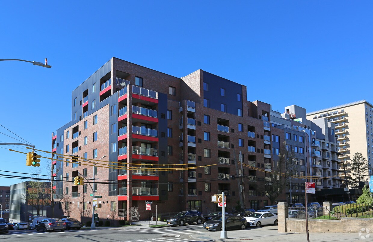
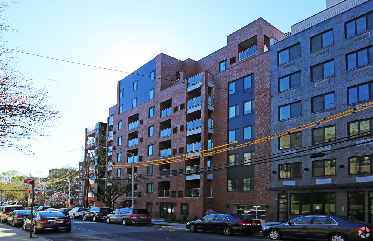

The Maya offers a mixture of comfort, quality, and design. The 177-30 Wexford Ter location in the 11432 neighborhood of Jamaica is perfectly situated for work or play. When you choose an apartment at The Maya, you'll have access to top features and amenities including: a state-of-the-art fitness center, balconies, and a doorman. From pricing to features, the leasing staff will assist you in finding your dream apartment. Contact us or stop by today.
The Maya is an apartment community located in Queens County and the 11432 ZIP Code. This area is served by the New York City Geographic District #29 attendance zone.
Fitness Center
Laundry Facilities
Elevator
Doorman
Air Conditioning
Dishwasher
Tub/Shower
Cable Ready
In the center of Queens, you’ll come upon one of the most tree-filled neighborhoods in New York City, a unique quality for an urban area. Originally created to be a luxurious, suburban escape from Manhattan, Jamaica Estates houses historic mansions, including Donald Trump’s childhood home, and exudes a park-like atmosphere.
This historic neighborhood boasts a family-friendly environment with a variety of apartments and houses for rent. Nearby subway and bus stations make traveling in and out of Jamaica Estates a breeze, along with easy access to major roads like Grand Central Parkway and Hillside Avenue. Travel along Hillside Avenue on the south end of town for banks, restaurants, supermarkets, and more conveniences.
Jamaica Estates borders the expansive Cunningham Park on its east and Saint John’s University Queens Campus on its west.
Learn more about living in Jamaica Estates| Colleges & Universities | Distance | ||
|---|---|---|---|
| Colleges & Universities | Distance | ||
| Drive: | 5 min | 1.2 mi | |
| Drive: | 3 min | 1.6 mi | |
| Drive: | 10 min | 4.8 mi | |
| Drive: | 9 min | 5.0 mi |


Transportation options available in Jamaica include Jamaica-179 Street, located 0.1 mile from The Maya. The Maya is near John F Kennedy International, located 7.6 miles or 11 minutes away, and LaGuardia, located 8.1 miles or 14 minutes away.
| Transit / Subway | Distance | ||
|---|---|---|---|
| Transit / Subway | Distance | ||
|
|
Walk: | 1 min | 0.1 mi |
|
|
Walk: | 8 min | 0.4 mi |
|
|
Walk: | 19 min | 1.0 mi |
|
|
Drive: | 3 min | 1.4 mi |
|
|
Drive: | 3 min | 1.5 mi |
| Commuter Rail | Distance | ||
|---|---|---|---|
| Commuter Rail | Distance | ||
|
|
Walk: | 15 min | 0.8 mi |
|
|
Drive: | 4 min | 1.3 mi |
|
|
Drive: | 4 min | 1.8 mi |
|
|
Drive: | 7 min | 2.4 mi |
|
|
Drive: | 7 min | 3.0 mi |
| Airports | Distance | ||
|---|---|---|---|
| Airports | Distance | ||
|
John F Kennedy International
|
Drive: | 11 min | 7.6 mi |
|
LaGuardia
|
Drive: | 14 min | 8.1 mi |
Time and distance from The Maya.
| Shopping Centers | Distance | ||
|---|---|---|---|
| Shopping Centers | Distance | ||
| Walk: | 15 min | 0.8 mi | |
| Drive: | 4 min | 1.2 mi | |
| Drive: | 3 min | 1.4 mi |
| Parks and Recreation | Distance | ||
|---|---|---|---|
| Parks and Recreation | Distance | ||
|
Rufus King Park
|
Drive: | 3 min | 1.5 mi |
|
Detective Keith L. Williams Park
|
Drive: | 4 min | 1.7 mi |
|
Roy Wilkins Recreation Center
|
Drive: | 7 min | 2.7 mi |
|
Cunningham Park
|
Drive: | 6 min | 3.0 mi |
|
Kissena Park
|
Drive: | 9 min | 3.5 mi |
| Hospitals | Distance | ||
|---|---|---|---|
| Hospitals | Distance | ||
| Drive: | 4 min | 1.6 mi | |
| Drive: | 4 min | 2.0 mi | |
| Drive: | 6 min | 3.5 mi |
| Military Bases | Distance | ||
|---|---|---|---|
| Military Bases | Distance | ||
| Drive: | 12 min | 7.7 mi | |
| Drive: | 33 min | 16.4 mi |
What Are Walk Score®, Transit Score®, and Bike Score® Ratings?
Walk Score® measures the walkability of any address. Transit Score® measures access to public transit. Bike Score® measures the bikeability of any address.
What is a Sound Score Rating?
A Sound Score Rating aggregates noise caused by vehicle traffic, airplane traffic and local sources

177-30 Wexford Ter
Jamaica, NY 11432


