
Halletts Point
10, 20, 30 Halletts Pt,
Astoria, NY 11102
$3,356 - $7,526
1-2 Beds
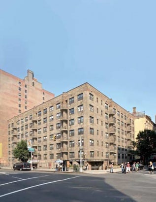
The Left Bank® is an elevator building comprised of studios and 1 bedrooms accompanied by laundry facilities, a gym and an attended garage.
The Left Bank® is an apartment community located in New York County and the 10011 ZIP Code. This area is served by the New York City Geographic District # 2 attendance zone.
Fitness Center
Laundry Facilities
Elevator
Property Manager on Site
Air Conditioning
Microwave
Refrigerator
Freezer
Historic, lively, and in the heart of it all, Union Square is one of Manhattan’s most iconic neighborhoods. Union Square wraps around Union Square Park, a National Historic Landmark dating back to 1839, and is the host of the popular Greenmarket, a farmers market open every Monday, Wednesday, Friday, and Saturday. Readers, runners, chess players, dog walkers, and all different kinds of visitors venture to this park on a daily basis.
Surrounded by other popular neighborhoods like the Flatiron District and Greenwich Village, renters in Union Square have easy access to all of Manhattan through the area’s various subway stations, iconic yellow cabs, public buses, and walkable and bikeable urban streets. Venture to local retailers and restaurants such as Breads Bakery for delicious deserts, Raines Law Room Chelsea for speakeasy cocktails, Basta Pasta for upscale Italian dishes, or Barn Joo for Korean barbeque.
Learn more about living in Union Square| Colleges & Universities | Distance | ||
|---|---|---|---|
| Colleges & Universities | Distance | ||
| Walk: | 13 min | 0.7 mi | |
| Walk: | 16 min | 0.8 mi | |
| Walk: | 17 min | 0.9 mi | |
| Walk: | 18 min | 0.9 mi |


Transportation options available in New York include 14 Street (F Line), located 0.0 mile from The Left Bank®. The Left Bank® is near LaGuardia, located 9.8 miles or 20 minutes away, and Newark Liberty International, located 12.9 miles or 21 minutes away.
| Transit / Subway | Distance | ||
|---|---|---|---|
| Transit / Subway | Distance | ||
|
|
Walk: | 0 min | 0.0 mi |
|
|
Walk: | 1 min | 0.1 mi |
|
|
Walk: | 5 min | 0.3 mi |
|
|
Walk: | 6 min | 0.3 mi |
| Walk: | 6 min | 0.3 mi |
| Commuter Rail | Distance | ||
|---|---|---|---|
| Commuter Rail | Distance | ||
|
|
Walk: | 1 min | 0.1 mi |
|
|
Walk: | 6 min | 0.3 mi |
|
|
Walk: | 7 min | 0.4 mi |
|
|
Walk: | 14 min | 0.7 mi |
|
|
Drive: | 5 min | 1.3 mi |
| Airports | Distance | ||
|---|---|---|---|
| Airports | Distance | ||
|
LaGuardia
|
Drive: | 20 min | 9.8 mi |
|
Newark Liberty International
|
Drive: | 21 min | 12.9 mi |
Time and distance from The Left Bank®.
| Shopping Centers | Distance | ||
|---|---|---|---|
| Shopping Centers | Distance | ||
| Walk: | 7 min | 0.4 mi | |
| Drive: | 7 min | 1.6 mi | |
| Drive: | 5 min | 1.7 mi |
| Parks and Recreation | Distance | ||
|---|---|---|---|
| Parks and Recreation | Distance | ||
|
Union Square Park
|
Walk: | 7 min | 0.4 mi |
|
Washington Square Park
|
Walk: | 12 min | 0.6 mi |
|
Madison Square Park
|
Walk: | 13 min | 0.7 mi |
|
Chelsea Recreation Center
|
Drive: | 3 min | 1.1 mi |
|
Merchant's House Museum
|
Drive: | 4 min | 1.2 mi |
| Hospitals | Distance | ||
|---|---|---|---|
| Hospitals | Distance | ||
| Walk: | 14 min | 0.7 mi | |
| Drive: | 4 min | 1.1 mi | |
| Drive: | 5 min | 1.5 mi |
| Military Bases | Distance | ||
|---|---|---|---|
| Military Bases | Distance | ||
| Drive: | 11 min | 4.0 mi | |
| Drive: | 19 min | 10.3 mi |
What Are Walk Score®, Transit Score®, and Bike Score® Ratings?
Walk Score® measures the walkability of any address. Transit Score® measures access to public transit. Bike Score® measures the bikeability of any address.
What is a Sound Score Rating?
A Sound Score Rating aggregates noise caused by vehicle traffic, airplane traffic and local sources

77 W 15th St
New York, NY 10011


