
Halletts Point
10, 20, 30 Halletts Pt,
Astoria, NY 11102
$3,356 - $7,526
1-2 Beds

Bedrooms
Studio - 3 bd
Bathrooms
1 - 2 ba
Square Feet
--
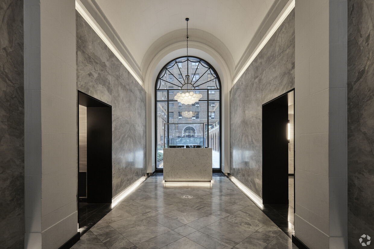
*advertised pricing may include promotional rent The Buchanan is set in the heart of Turtle Bay, a classic Manhattan neighborhood tucked between the East River and Midtown. Rich in history, it is home to the United Nations, the Chrysler Building, and Grand Central Terminal, among other internationally recognized icons. Just a few blocks from the energy of the Midtown business district, Turtle Bay’s residential streets are filled with a variety of upscale restaurants and lounges and bordered by a lush waterfront park. The Buchanan brings modern luxury together with iconic prewar elegance in spacious, light-filled studio to three-bedroom residences. Refined finishes in a neutral palette, including hardwood flooring and marble-tile bathrooms, accommodate a range of interior design preferences, from traditional to contemporary. Expansive bedrooms and ample closet space contribute to an elevated ambience, while thoughtfully designed kitchens will inspire chef-quality cuisine at home. In addition to the acoustic benefits of original prewar construction, with only four residences per floor, The Buchanan provides a welcome level of privacy and tranquility.
The Buchanan is an apartment community located in New York County and the 10017 ZIP Code. This area is served by the New York City Geographic District # 2 attendance zone.
Fitness Center
Laundry Facilities
Elevator
Concierge
Washer/Dryer
Air Conditioning
Dishwasher
Hardwood Floors
Some of Manhattan’s most iconic structures, from the Empire State Building and the Chrysler Building to Grand Central Station and Rockefeller Center, are located in the busy, bustling Midtown East neighborhood. As a result, there are arguably more tourists than locals walking the streets – but that just adds to Midtown East’s endless appeal. As you’ll be living here and not just gazing at the architecture, you’ll be happy to know that not only is Midtown East home to some of the city’s largest employers, but there are also multiple subway stops throughout the neighborhood – as well as city bus service and the iconic yellow taxis.
Midtown East sits directly east of the Theater District and extends to the East River. It runs from 42nd Street north to E 59th Street, with the UN Headquarters in the southeast corner and the south corner of Central Park at the northwest corner.
Learn more about living in Midtown East| Colleges & Universities | Distance | ||
|---|---|---|---|
| Colleges & Universities | Distance | ||
| Walk: | 9 min | 0.5 mi | |
| Walk: | 14 min | 0.8 mi | |
| Drive: | 4 min | 1.2 mi | |
| Drive: | 3 min | 1.3 mi |


Transportation options available in New York include 51 Street, located 0.2 mile from The Buchanan. The Buchanan is near LaGuardia, located 7.0 miles or 15 minutes away, and Newark Liberty International, located 15.2 miles or 22 minutes away.
| Transit / Subway | Distance | ||
|---|---|---|---|
| Transit / Subway | Distance | ||
|
|
Walk: | 3 min | 0.2 mi |
| Walk: | 3 min | 0.2 mi | |
|
|
Walk: | 5 min | 0.3 mi |
|
|
Walk: | 10 min | 0.5 mi |
|
|
Walk: | 10 min | 0.5 mi |
| Commuter Rail | Distance | ||
|---|---|---|---|
| Commuter Rail | Distance | ||
|
|
Walk: | 6 min | 0.3 mi |
|
|
Walk: | 10 min | 0.5 mi |
|
|
Drive: | 5 min | 1.7 mi |
|
|
Drive: | 4 min | 1.8 mi |
|
|
Drive: | 7 min | 2.7 mi |
| Airports | Distance | ||
|---|---|---|---|
| Airports | Distance | ||
|
LaGuardia
|
Drive: | 15 min | 7.0 mi |
|
Newark Liberty International
|
Drive: | 22 min | 15.2 mi |
Time and distance from The Buchanan.
| Shopping Centers | Distance | ||
|---|---|---|---|
| Shopping Centers | Distance | ||
| Walk: | 10 min | 0.5 mi | |
| Drive: | 4 min | 1.4 mi | |
| Drive: | 4 min | 1.6 mi |
| Parks and Recreation | Distance | ||
|---|---|---|---|
| Parks and Recreation | Distance | ||
|
Sony Wonder Technology Lab
|
Walk: | 12 min | 0.6 mi |
|
St. Catherine's Park
|
Drive: | 3 min | 1.2 mi |
|
Central Park Zoo
|
Drive: | 4 min | 1.3 mi |
|
Bryant Park
|
Drive: | 4 min | 1.6 mi |
|
Gantry Plaza State Park
|
Drive: | 7 min | 2.8 mi |
| Hospitals | Distance | ||
|---|---|---|---|
| Hospitals | Distance | ||
| Drive: | 5 min | 1.4 mi | |
| Drive: | 4 min | 1.4 mi | |
| Drive: | 5 min | 1.9 mi |
| Military Bases | Distance | ||
|---|---|---|---|
| Military Bases | Distance | ||
| Drive: | 15 min | 7.2 mi | |
| Drive: | 26 min | 13.3 mi |
What Are Walk Score®, Transit Score®, and Bike Score® Ratings?
Walk Score® measures the walkability of any address. Transit Score® measures access to public transit. Bike Score® measures the bikeability of any address.
What is a Sound Score Rating?
A Sound Score Rating aggregates noise caused by vehicle traffic, airplane traffic and local sources
770 3rd Ave
New York, NY 10017


