
Villas las Naranjas
1345 S Kolb Rd,
Tucson, AZ 85710
$749 - $1,399
1-3 Beds

Bedrooms
Studio - 2 bd
Bathrooms
1 ba
Square Feet
330 - 740 sq ft
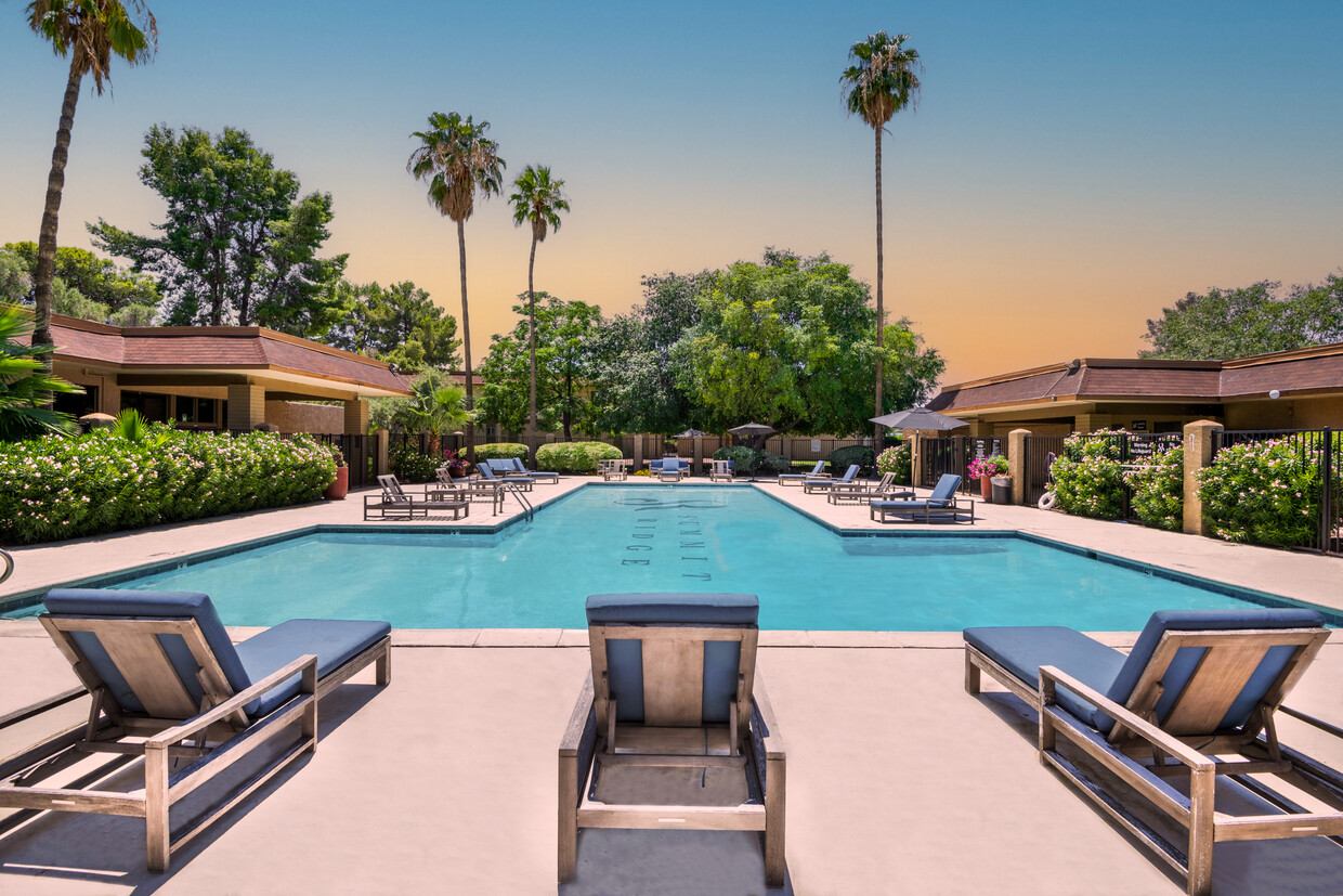
Summit Ridge Apartments are located in Tucson, AZ on South Craycroft Road. Come home to our convenient and tranquil location, where we offer deluxe amenities and gracious apartment living for your family. Our lovely community offers lush and tropical landscaping, a modern business facility with full internet access and computers as well as our state of the art fitness center for your health benefits. Our complex offers the complete package in terms of luxury living – don’t wait; make Summit Ridge you home today. *Additional fees may apply.
Summit Ridge is an apartment community located in Pima County and the 85711 ZIP Code. This area is served by the Tucson Unified District attendance zone.
Unique Features
Pool
Fitness Center
Grill
Key Fob Entry
Air Conditioning
High Speed Internet Access
Walk-In Closets
Island Kitchen
Refrigerator
Wi-Fi
Tub/Shower
Disposal
Tucked between the scenic Tucson and Santa Catalina mountains, the neighborhood of Myers shines -- both as a result of the Arizona sun and its scenic location. This South Tucson neighborhood borders Davis-Monthan Air Force Base on the south side and is just six miles southeast of the University of Arizona. Defined by ranch homes and a landscape that includes rocks and palm trees, Myers is deceptively suburban -- it is just six miles from Downtown Tucson, a 15-minute drive from the Tucson International Airport, and three miles from Reid Park Zoo. Myers connects its residential population of around 5,000 people to the downtown area via the Aviation Highway and Interstate 10.
Learn more about living in MyersCompare neighborhood and city base rent averages by bedroom.
| Myers | Tucson, AZ | |
|---|---|---|
| Studio | $646 | $790 |
| 1 Bedroom | $779 | $989 |
| 2 Bedrooms | $950 | $1,283 |
| 3 Bedrooms | $1,318 | $1,701 |
| Colleges & Universities | Distance | ||
|---|---|---|---|
| Colleges & Universities | Distance | ||
| Drive: | 12 min | 5.9 mi | |
| Drive: | 14 min | 7.2 mi | |
| Drive: | 15 min | 7.4 mi | |
| Drive: | 15 min | 8.0 mi |

Transportation options available in Tucson include Sl/2Nd St/Cherry Av, located 6.5 miles from Summit Ridge. Summit Ridge is near Tucson International, located 9.6 miles or 16 minutes away.
| Transit / Subway | Distance | ||
|---|---|---|---|
| Transit / Subway | Distance | ||
| Drive: | 14 min | 6.5 mi | |
| Drive: | 14 min | 6.5 mi | |
| Drive: | 13 min | 6.5 mi | |
| Drive: | 14 min | 6.6 mi | |
| Drive: | 14 min | 6.9 mi |
| Commuter Rail | Distance | ||
|---|---|---|---|
| Commuter Rail | Distance | ||
|
|
Drive: | 11 min | 6.0 mi |
| Airports | Distance | ||
|---|---|---|---|
| Airports | Distance | ||
|
Tucson International
|
Drive: | 16 min | 9.6 mi |
Scores provided by
Traffic
-Airport
-Businesses
-Scores provided by
HowLoud What is a Sound Score Rating? A Sound Score Rating aggregates noise caused by vehicle traffic, airplane traffic and local sources. How It WorksTime and distance from Summit Ridge.
| Shopping Centers | Distance | ||
|---|---|---|---|
| Shopping Centers | Distance | ||
| Walk: | 2 min | 0.1 mi | |
| Walk: | 4 min | 0.3 mi | |
| Walk: | 8 min | 0.4 mi |
| Parks and Recreation | Distance | ||
|---|---|---|---|
| Parks and Recreation | Distance | ||
|
Freedom Park
|
Drive: | 3 min | 1.1 mi |
|
Palo Verde Park
|
Drive: | 7 min | 2.3 mi |
|
Terra Del Sol Park
|
Drive: | 6 min | 2.3 mi |
|
Vista del Prado Park
|
Drive: | 7 min | 3.3 mi |
|
Escalante Park
|
Drive: | 7 min | 3.8 mi |
| Hospitals | Distance | ||
|---|---|---|---|
| Hospitals | Distance | ||
| Drive: | 5 min | 2.5 mi | |
| Drive: | 7 min | 3.5 mi | |
| Drive: | 6 min | 3.5 mi |
| Military Bases | Distance | ||
|---|---|---|---|
| Military Bases | Distance | ||
| Drive: | 9 min | 5.2 mi | |
| Drive: | 18 min | 9.7 mi | |
| Drive: | 85 min | 72.5 mi |
Pets Allowed Fitness Center In Unit Washer & Dryer Maintenance on site Stainless Steel Appliances Ceiling Fans Granite Countertops
What Are Walk Score®, Transit Score®, and Bike Score® Ratings?
Walk Score® measures the walkability of any address. Transit Score® measures access to public transit. Bike Score® measures the bikeability of any address.
What is a Sound Score Rating?
A Sound Score Rating aggregates noise caused by vehicle traffic, airplane traffic and local sources.
1252 S Craycroft Rd
Tucson, AZ 85711


