
Hancock Village
1 Hancock Village Dr,
Chestnut Hill, MA 02467
$2,890 - $10,805 Plus Fees
1-3 Beds 12 Month Lease
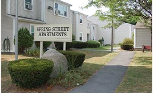
Discover your new home at Spring Street. This community is located at 23 Spring St. in the Upper Washington Spring St area of West Roxbury. The professional leasing staff is available to help you find the best floor plan for your lifestyle. Experience a new standard at Spring Street.
Spring Street is an apartment community located in Suffolk County and the 02132 ZIP Code. This area is served by the Boston Public Schools attendance zone.
Upper Washington-Spring Street is a neighborhood southwest of Boston in West Roxbury. Residents will find that Upper Washington-Spring Street is home to many cozy residential areas and great amenities. The neighborhood’s northern border sits along the Charles River and surrounding parks like Millennium Park, giving residents easy access to outdoor recreation. The hospital that serves this area, West Roxbury VAMC, sits along the river as well. Within Upper Washington-Spring Street, residents will find that picturesque parks like Ohrenberger Woodland Park dot the area. To the east of town, residents can travel along VFW Parkway to get to eateries and retail stores.
This neighborhood is a great town for commuters as the MBTA has both bus stops and rail lines accessible to the area. Apartments and condos scattered throughout town make up the majority of Upper Washington-Spring Street’s diverse rental options.
Learn more about living in Upper Washington-Spring StCompare neighborhood and city base rent averages by bedroom.
| Upper Washington-Spring St | West Roxbury, MA | |
|---|---|---|
| Studio | $1,745 | $1,763 |
| 1 Bedroom | $2,457 | $2,372 |
| 2 Bedrooms | $2,895 | $2,791 |
| 3 Bedrooms | $4,095 | $4,141 |
| Colleges & Universities | Distance | ||
|---|---|---|---|
| Colleges & Universities | Distance | ||
| Drive: | 14 min | 5.5 mi | |
| Drive: | 14 min | 6.2 mi | |
| Drive: | 14 min | 6.4 mi | |
| Drive: | 13 min | 6.9 mi |

Transportation options available in West Roxbury include Chestnut Hill Station, located 4.0 miles from Spring Street. Spring Street is near General Edward Lawrence Logan International, located 12.8 miles or 26 minutes away.
| Transit / Subway | Distance | ||
|---|---|---|---|
| Transit / Subway | Distance | ||
|
|
Drive: | 9 min | 4.0 mi |
|
|
Drive: | 9 min | 4.3 mi |
|
|
Drive: | 10 min | 4.4 mi |
|
|
Drive: | 9 min | 4.6 mi |
|
|
Drive: | 12 min | 5.0 mi |
| Commuter Rail | Distance | ||
|---|---|---|---|
| Commuter Rail | Distance | ||
|
|
Walk: | 7 min | 0.4 mi |
|
|
Walk: | 15 min | 0.8 mi |
|
|
Drive: | 3 min | 1.3 mi |
|
|
Drive: | 6 min | 2.1 mi |
|
|
Drive: | 10 min | 3.9 mi |
| Airports | Distance | ||
|---|---|---|---|
| Airports | Distance | ||
|
General Edward Lawrence Logan International
|
Drive: | 26 min | 12.8 mi |
Scores provided by
Traffic
ActiveAirport
CalmBusinesses
ActiveScores provided by
HowLoud What is a Sound Score Rating? A Sound Score Rating aggregates noise caused by vehicle traffic, airplane traffic and local sources. How It WorksTime and distance from Spring Street.
| Shopping Centers | Distance | ||
|---|---|---|---|
| Shopping Centers | Distance | ||
| Walk: | 4 min | 0.2 mi | |
| Walk: | 15 min | 0.8 mi | |
| Drive: | 4 min | 1.9 mi |
| Parks and Recreation | Distance | ||
|---|---|---|---|
| Parks and Recreation | Distance | ||
|
Brook Farm Historic Site
|
Walk: | 13 min | 0.7 mi |
|
Stony Brook Reservation
|
Drive: | 5 min | 2.1 mi |
|
Arnold Arboretum of Harvard University
|
Drive: | 6 min | 2.7 mi |
|
Cutler Park Reservation
|
Drive: | 7 min | 3.5 mi |
|
Mass Audubon's Boston Nature Center and Wildlife Sanctuary
|
Drive: | 12 min | 4.4 mi |
| Hospitals | Distance | ||
|---|---|---|---|
| Hospitals | Distance | ||
| Drive: | 5 min | 2.3 mi | |
| Drive: | 7 min | 3.1 mi | |
| Drive: | 10 min | 4.6 mi |
| Military Bases | Distance | ||
|---|---|---|---|
| Military Bases | Distance | ||
| Drive: | 22 min | 11.7 mi | |
| Drive: | 30 min | 17.8 mi | |
| Drive: | 50 min | 29.1 mi |
Pets Allowed Maintenance on site Heat Controlled Access Elevator Laundry Facilities
Pets Allowed Fitness Center Pool Dishwasher Kitchen In Unit Washer & Dryer
Fitness Center Clubhouse Balcony Stainless Steel Appliances Granite Countertops Smoke Free Basketball Court
Pets Allowed Fitness Center Dishwasher Refrigerator Kitchen In Unit Washer & Dryer
Pets Allowed Fitness Center Pool Walk-In Closets Business Center Package Service Elevator
What Are Walk Score®, Transit Score®, and Bike Score® Ratings?
Walk Score® measures the walkability of any address. Transit Score® measures access to public transit. Bike Score® measures the bikeability of any address.
What is a Sound Score Rating?
A Sound Score Rating aggregates noise caused by vehicle traffic, airplane traffic and local sources.


