
Williamsburg
200 W Galbraith Rd,
Cincinnati, OH 45215
$857 - $3,564
Studio - 3 Beds

Come home to the quiet relaxation of Sovereign Estates. Our property features lush landscaping in a quiet, peaceful environment. You will enjoy the spacious apartments and wonderful neighbors. This community is professionally managed with excellent management and maintenance staff. Call our leasing office today for more information on your new home at Sovereign Estates.
Sovereign Estates is an apartment community located in Hamilton County and the 45251 ZIP Code. This area is served by the Northwest Local attendance zone.
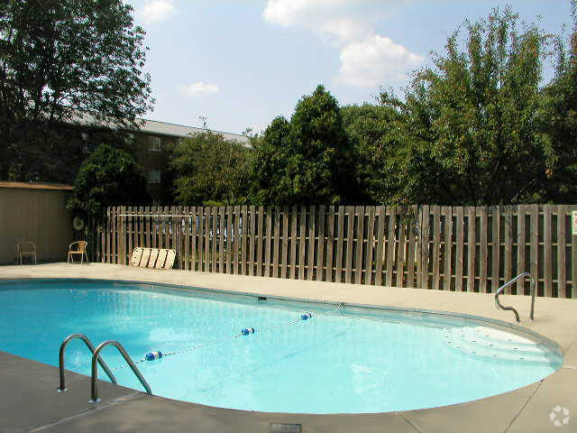
Piscina exterior
Control de accesos
Property manager in situ
Mantenimiento in situ
Aire acondicionado
Lavavajillas
Acceso a Internet de alta velocidad
Vestidores
Originally called West Union, Groesbeck is a charming Cincinnati community located just over 10 miles north of downtown. Technically a census-designated place, Groesbeck is home to nature preserves and shopping centers that will keep residents entertained and active well within the borders of their own community. The Groesbeck area is frequently rated as one of the top places in Cincinnati to raise a family, but you’ll find a wide variety of people enjoying the suburban atmosphere. A top school district and urban amenities off Ronald Reagan Cross County Highway, including popular fried chicken restaurants, make Groesbeck great. Low-rise apartments and long-standing homes remain affordable, and the buzz of Downtown Cincinnati is just a short drive south.
Learn more about living in GroesbeckCompare neighborhood and city base rent averages by bedroom.
| Groesbeck | Cincinnati, OH | |
|---|---|---|
| Studio | - | $1,062 |
| 1 Bedroom | $965 | $1,129 |
| 2 Bedrooms | $1,079 | $1,407 |
| 3 Bedrooms | $889 | $1,704 |
| Colleges & Universities | Distance | ||
|---|---|---|---|
| Colleges & Universities | Distance | ||
| Drive: | 21 min | 7.6 mi | |
| Drive: | 21 min | 9.2 mi | |
| Drive: | 23 min | 9.7 mi | |
| Drive: | 21 min | 12.7 mi |


Transportation options available in Cincinnati include Brewery District Station - Elm & Henry, located 10.0 miles from Sovereign Estates. Sovereign Estates is near Cincinnati/Northern Kentucky International, located 24.0 miles or 46 minutes away.
| Transit / Subway | Distance | ||
|---|---|---|---|
| Transit / Subway | Distance | ||
| Drive: | 22 min | 10.0 mi | |
| Drive: | 23 min | 10.0 mi | |
| Drive: | 23 min | 10.1 mi | |
| Drive: | 23 min | 10.2 mi | |
| Drive: | 23 min | 10.3 mi |
| Commuter Rail | Distance | ||
|---|---|---|---|
| Commuter Rail | Distance | ||
|
|
Drive: | 22 min | 9.9 mi |
| Airports | Distance | ||
|---|---|---|---|
| Airports | Distance | ||
|
Cincinnati/Northern Kentucky International
|
Drive: | 46 min | 24.0 mi |
Time and distance from Sovereign Estates.
| Shopping Centers | Distance | ||
|---|---|---|---|
| Shopping Centers | Distance | ||
| Walk: | 15 min | 0.8 mi | |
| Walk: | 15 min | 0.8 mi | |
| Walk: | 16 min | 0.8 mi |
| Parks and Recreation | Distance | ||
|---|---|---|---|
| Parks and Recreation | Distance | ||
|
Farbach-Werner Nature Preserve
|
Walk: | 18 min | 0.9 mi |
|
LaBoiteaux Woods
|
Drive: | 12 min | 4.6 mi |
|
Mt. Airy Forest
|
Drive: | 13 min | 4.9 mi |
|
Triple Creek Park
|
Drive: | 13 min | 5.0 mi |
|
Winton Woods Park
|
Drive: | 16 min | 7.8 mi |
| Hospitals | Distance | ||
|---|---|---|---|
| Hospitals | Distance | ||
| Drive: | 14 min | 5.2 mi | |
| Drive: | 20 min | 8.5 mi | |
| Drive: | 13 min | 8.7 mi |
| Military Bases | Distance | ||
|---|---|---|---|
| Military Bases | Distance | ||
| Drive: | 68 min | 51.3 mi | |
| Drive: | 74 min | 56.3 mi | |
| Drive: | 76 min | 59.6 mi |
What Are Walk Score®, Transit Score®, and Bike Score® Ratings?
Walk Score® measures the walkability of any address. Transit Score® measures access to public transit. Bike Score® measures the bikeability of any address.
What is a Sound Score Rating?
A Sound Score Rating aggregates noise caused by vehicle traffic, airplane traffic and local sources
3101-3111 Regal Ln
Cincinnati, OH 45251


