$2,825
/ Month
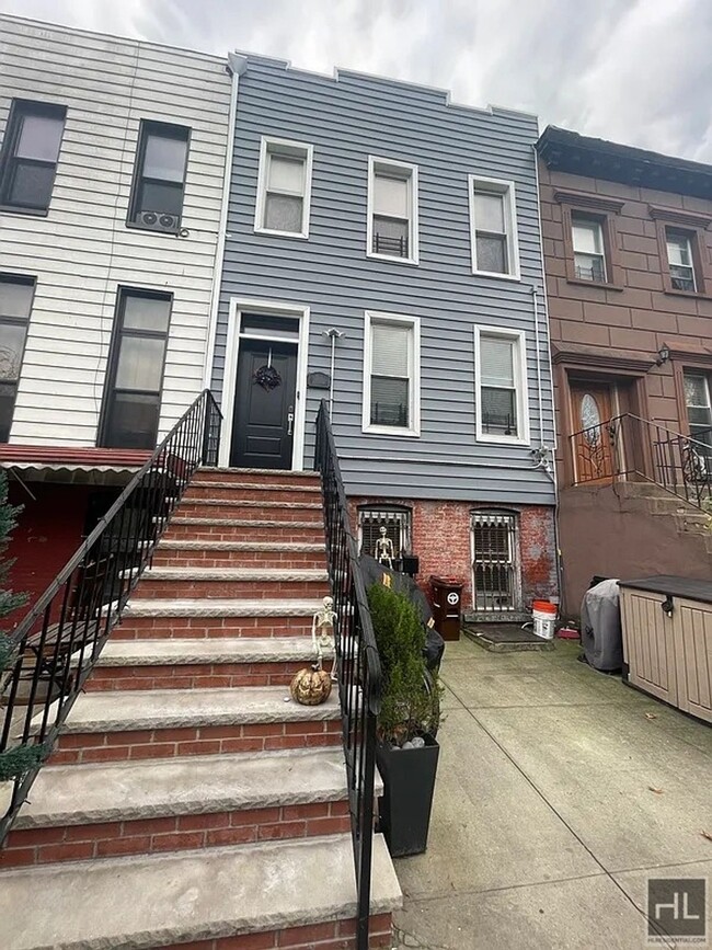
564 Quincy St
Brooklyn, NY 11221
Favorites
QUINCY STREET

Favorites
Check Back Soon for Upcoming Availability
| Beds | Baths | Average SF |
|---|---|---|
| 2 Bedrooms 2 Bedrooms 2 Br | 1 Bath 1 Bath 1 Ba | — |
About This Property
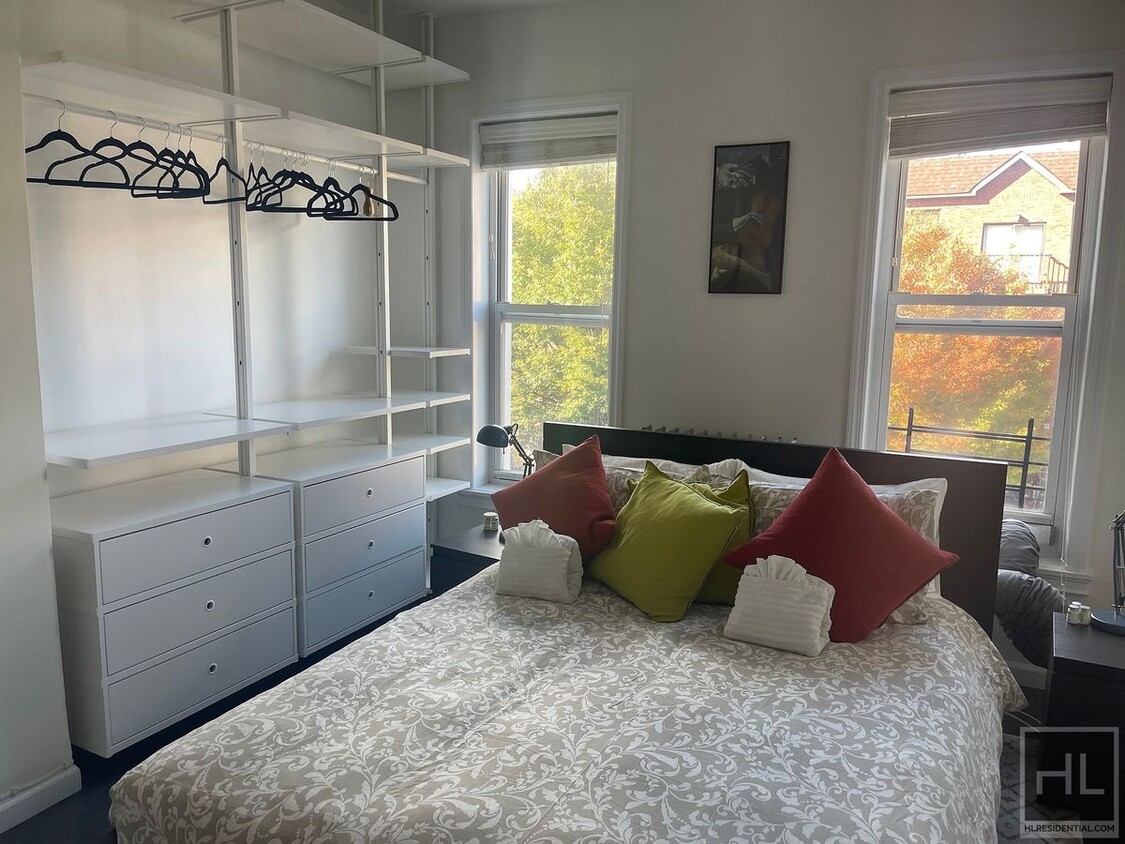
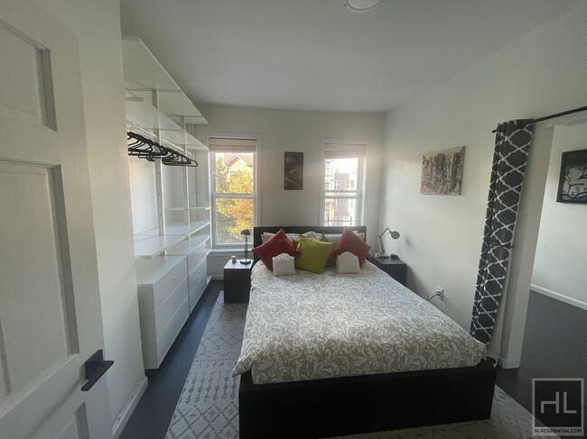
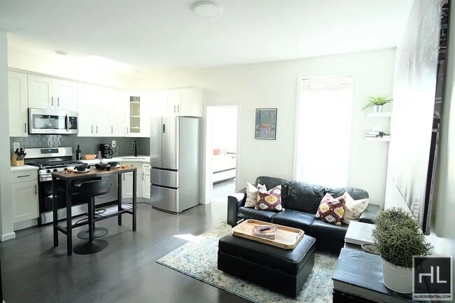
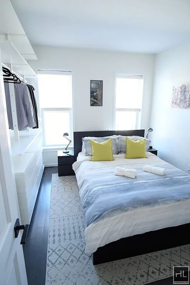
Gorgeous huge apartment, located in the prime Bedstuy area. A MUST SEE! Conveniently located close to the G/J/M/Z train lines and various bus lines B25, B20, B83, B60, Q24. For a fast and easy commute. A few minutes away from many bars restaurants cafe shops and groceries. The building is clean quiet and well maintained. The apartment features: Newly Renovated, Hardwood Floors, High Ceiling, Large Windows With Lots Of Natural Light, 2 Huge Bedrooms With Lots Of Closet Space 1 Modern Full Bath, Gorgeous Kitchen Sorry no Pets ===Ref:1776514===
QUINCY STREET is an apartment community located in Kings County and the 11221 ZIP Code.
564 Quincy St,
Brooklyn,
NY
11221
Bedford-Stuyvesant, often shortened to Bed-Stuy, sits in north central Brooklyn, touting plenty of classic brownstones along tree-lined streets. Bed-Stuy is revered for its historic architecture, containing one of the highest concentrations of Victorian properties in all of New York City.
Residents enjoy a strong sense of community in Bed-Stuy along with an array of diverse eateries, cafes, and bodegas. Herbert Von King Park lies at the center of the neighborhood, exuding a lively town-square atmosphere with an outdoor amphitheater, Cultural Arts Center, and athletic facilities. Convenience to public transportation and I-278 makes commuting and traveling from Bed-Stuy a breeze.
Learn more about living in Bedford StuyvesantBelow are rent ranges for similar nearby apartments
| Beds | Average Size | Lowest | Typical | Premium |
|---|---|---|---|---|
| Studio Studio Studio | 500 Sq Ft | $1,000 | $2,419 | $3,995 |
| 1 Bed 1 Bed 1 Bed | 426-440 Sq Ft | $1,200 | $2,681 | $6,535 |
| 2 Beds 2 Beds 2 Beds | 931-933 Sq Ft | $990 | $3,072 | $6,500 |
| 3 Beds 3 Beds 3 Beds | 429 Sq Ft | $1,325 | $2,395 | $5,950 |
| 4 Beds 4 Beds 4 Beds | 181 Sq Ft | $1,200 | $1,630 | $9,013 |
Education
| Colleges & Universities | Distance | ||
|---|---|---|---|
| Colleges & Universities | Distance | ||
| Drive: | 6 min | 1.8 mi | |
| Drive: | 7 min | 2.1 mi | |
| Drive: | 8 min | 2.7 mi | |
| Drive: | 9 min | 2.7 mi |
QUINCY STREET is within 6 minutes or 1.8 miles from Pratt Institute. It is also near Saint Joseph's Coll, Brooklyn and Medgar Evers College, CUNY.
Transportation options available in Brooklyn include Kosciuszko Street, located 0.8 mile from QUINCY STREET. QUINCY STREET is near LaGuardia, located 8.9 miles or 19 minutes away, and John F Kennedy International, located 10.9 miles or 21 minutes away.
| Transit / Subway | Distance | ||
|---|---|---|---|
| Transit / Subway | Distance | ||
|
|
Walk: | 15 min | 0.8 mi |
|
|
Walk: | 15 min | 0.8 mi |
|
|
Walk: | 17 min | 0.9 mi |
|
|
Drive: | 4 min | 1.1 mi |
|
|
Drive: | 4 min | 1.2 mi |
| Commuter Rail | Distance | ||
|---|---|---|---|
| Commuter Rail | Distance | ||
|
|
Drive: | 5 min | 1.7 mi |
|
|
Drive: | 6 min | 2.5 mi |
|
|
Drive: | 9 min | 2.6 mi |
|
|
Drive: | 14 min | 4.6 mi |
|
|
Drive: | 15 min | 4.9 mi |
| Airports | Distance | ||
|---|---|---|---|
| Airports | Distance | ||
|
LaGuardia
|
Drive: | 19 min | 8.9 mi |
|
John F Kennedy International
|
Drive: | 21 min | 10.9 mi |
Walkability Near QUINCY STREET
Getting Around
 What do Walkability, Transit, Drivability, and Bikeability mean?
Walkability measures the walking distance to day-to-day needs.
Transit measures access to public transportation.
Drivability measures congestion, parking availability, and access to major roads.
Bikeability measures the suitability for cycling.
How It Works
What do Walkability, Transit, Drivability, and Bikeability mean?
Walkability measures the walking distance to day-to-day needs.
Transit measures access to public transportation.
Drivability measures congestion, parking availability, and access to major roads.
Bikeability measures the suitability for cycling.
How It Works
Exceptionally Walkable
Walkability
100
/ 100
Exceptional Public Transit
Transit
100
/ 100
Fairly Drivable
Drivability
40
/ 100
Moderately Bikeable
Bikeability
70
/ 100
Scores provided by
-
Soundscore™
-
/ 100
Traffic
-Airport
-Businesses
-Scores provided by
HowLoud What is a Sound Score Rating? A Sound Score Rating aggregates noise caused by vehicle traffic, airplane traffic and local sources. How It WorksTime and distance from QUINCY STREET.
| Shopping Centers | Distance | ||
|---|---|---|---|
| Shopping Centers | Distance | ||
| Drive: | 7 min | 2.3 mi |
QUINCY STREET has 1 shopping centers within 2.3 miles, which is about a 7-minute drive. The miles and minutes will be for the farthest away property.
| Parks and Recreation | Distance | ||
|---|---|---|---|
| Parks and Recreation | Distance | ||
|
St. John's Park
|
Drive: | 5 min | 1.4 mi |
|
Hattie Carthan Garden
|
Drive: | 5 min | 1.5 mi |
|
Brooklyn Children's Museum
|
Drive: | 6 min | 1.6 mi |
|
Maria Hernandez Park
|
Drive: | 5 min | 1.8 mi |
|
Crispus Attucks Playground
|
Drive: | 6 min | 2.0 mi |
QUINCY STREET has 5 parks within 2.0 miles, including Hattie Carthan Garden, St. John's Park, and Brooklyn Children's Museum.
| Hospitals | Distance | ||
|---|---|---|---|
| Hospitals | Distance | ||
| Walk: | 17 min | 0.9 mi | |
| Drive: | 4 min | 1.4 mi | |
| Drive: | 5 min | 1.9 mi |
QUINCY STREET has 3 hospitals within 1.9 miles, the nearest is Woodhull Medical & Mental Health Center which is 0.9 mile away and a 17 minute walk.
| Military Bases | Distance | ||
|---|---|---|---|
| Military Bases | Distance | ||
| Drive: | 20 min | 7.3 mi | |
| Drive: | 28 min | 10.3 mi | |
| Drive: | 24 min | 11.7 mi |
QUINCY STREET has 3 military bases within 11.7 miles, the nearest is Governors Island Support Center which is 7.3 miles away and a 20 minute drive.
You May Also Like
Similar Rentals Nearby


What Are Walk Score®, Transit Score®, and Bike Score® Ratings?
Walk Score® measures the walkability of any address. Transit Score® measures access to public transit. Bike Score® measures the bikeability of any address.
What is a Sound Score Rating?
A Sound Score Rating aggregates noise caused by vehicle traffic, airplane traffic and local sources.

564 Quincy St
Brooklyn, NY 11221