
1213 Walnut
1213 Walnut St,
Philadelphia, PA 19107
$1,645 - $5,440
Studio - 2 Beds

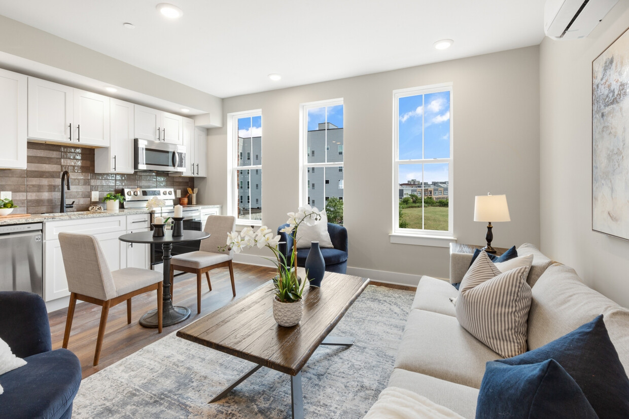
Welcome to Quaker City Flats, a new construction rental community at 1924 N Front St in East Kensington. Offering 32 modern units designed for those who seek a contemporary, pet-friendly lifestyle. Each unit is a masterpiece, boasting open floor plans, wood floors, and large windows that flood the space with light. The kitchens are equipped with white shaker cabinets, stylish tile backsplashes, and top-of-the-line stainless steel appliances. Luxurious bathrooms feature granite-topped vanities and subway tiled bathtub/shower combos. Convenience is at your fingertips with mini-split A/C systems and in-unit laundry. Our professionally managed building offers amenities including a main lobby and secure package room to ensure peace of mind. An elevator and two stairwells ensure easy access throughout the building. The shared roof deck offers city views, creating an ideal space for relaxation and entertainment. Limited parking is available, with three dedicated spots at the rear of the building for an additional fee. Experience the thrill of modern luxury and convenience in the heart of urban living. Schedule a tour today to discover your new home!
Quaker City Flats is an apartment community located in Philadelphia County and the 19122 ZIP Code. This area is served by the The School District of Philadelphia attendance zone.
Unique Features
Elevator
Roof Terrace
Controlled Access
Key Fob Entry
Washer/Dryer
Air Conditioning
Dishwasher
Hardwood Floors
Granite Countertops
Microwave
Refrigerator
Tub/Shower
Not to be confused with Northeast Philadelphia, North Philadelphia East encompasses the smaller subsets of Ludlow, Yorktown, West Kensington, Poplar, and Callowhill. This composite area runs from the Vine Street Expressway, stretching north to Erie Avenue. Broad Street acts as its eastern border, and the western edge runs a jagged line separating North Philadelphia East from the nearby Kensington, Port Richmond, and Fishtown neighborhoods. With such a long stretch of city, the neighborhood offers a diverse blend of important city landmarks, such as renowned musical venues the Electric Factory and Union Transfer, and Temple University, North Philadelphia's premiere site of higher learning.
Learn more about living in North Philadelphia EastCompare neighborhood and city base rent averages by bedroom.
| North Philadelphia East | Philadelphia, PA | |
|---|---|---|
| Studio | $1,466 | $1,403 |
| 1 Bedroom | $1,640 | $1,731 |
| 2 Bedrooms | $2,015 | $2,173 |
| 3 Bedrooms | $2,725 | $3,005 |
| Colleges & Universities | Distance | ||
|---|---|---|---|
| Colleges & Universities | Distance | ||
| Drive: | 4 min | 1.7 mi | |
| Drive: | 6 min | 2.6 mi | |
| Drive: | 9 min | 3.1 mi | |
| Drive: | 10 min | 4.6 mi |


Transportation options available in Philadelphia include Berks, located 0.1 mile from Quaker City Flats. Quaker City Flats is near Philadelphia International, located 14.6 miles or 25 minutes away, and Trenton Mercer, located 31.7 miles or 48 minutes away.
| Transit / Subway | Distance | ||
|---|---|---|---|
| Transit / Subway | Distance | ||
|
|
Walk: | 1 min | 0.1 mi |
|
|
Walk: | 7 min | 0.4 mi |
| Walk: | 13 min | 0.7 mi | |
| Walk: | 14 min | 0.7 mi | |
| Walk: | 14 min | 0.8 mi |
| Commuter Rail | Distance | ||
|---|---|---|---|
| Commuter Rail | Distance | ||
|
|
Walk: | 18 min | 1.0 mi |
|
|
Drive: | 5 min | 2.0 mi |
|
|
Drive: | 5 min | 2.2 mi |
|
|
Drive: | 7 min | 2.6 mi |
|
|
Drive: | 8 min | 3.0 mi |
| Airports | Distance | ||
|---|---|---|---|
| Airports | Distance | ||
|
Philadelphia International
|
Drive: | 25 min | 14.6 mi |
|
Trenton Mercer
|
Drive: | 48 min | 31.7 mi |
Time and distance from Quaker City Flats.
| Shopping Centers | Distance | ||
|---|---|---|---|
| Shopping Centers | Distance | ||
| Walk: | 20 min | 1.1 mi | |
| Drive: | 4 min | 1.2 mi | |
| Drive: | 4 min | 1.7 mi |
| Parks and Recreation | Distance | ||
|---|---|---|---|
| Parks and Recreation | Distance | ||
|
Wagner Free Institute of Science
|
Drive: | 5 min | 2.1 mi |
|
Edgar Allan Poe Nat'l Historic Site
|
Drive: | 5 min | 2.1 mi |
|
Great Egg Harbor River
|
Drive: | 6 min | 2.4 mi |
|
Lower Delaware National Wild and Scenic River
|
Drive: | 6 min | 2.4 mi |
|
Independence National Historical Park
|
Drive: | 6 min | 2.7 mi |
| Hospitals | Distance | ||
|---|---|---|---|
| Hospitals | Distance | ||
| Drive: | 5 min | 2.1 mi | |
| Drive: | 6 min | 2.8 mi | |
| Drive: | 7 min | 2.9 mi |
| Military Bases | Distance | ||
|---|---|---|---|
| Military Bases | Distance | ||
| Drive: | 15 min | 8.9 mi |
What Are Walk Score®, Transit Score®, and Bike Score® Ratings?
Walk Score® measures the walkability of any address. Transit Score® measures access to public transit. Bike Score® measures the bikeability of any address.
What is a Sound Score Rating?
A Sound Score Rating aggregates noise caused by vehicle traffic, airplane traffic and local sources
1924 N Front St
Philadelphia, PA 19122


