
Edison Austin
4711 E Riverside Dr,
Austin, TX 78741
$1,095 - $2,745
Studio - 2 Beds
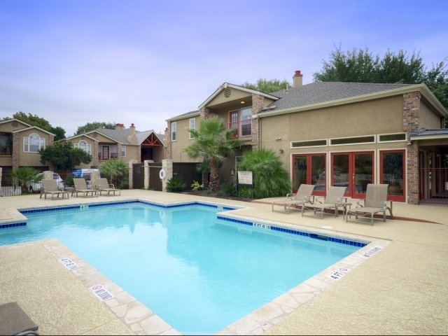

Pointe 360 Apartments in Austin, TX is located along the scenic hill country corridor of Capital of Texas Highway, just across the street from the Bull Creek Preserve. Conveniently located near the fine shopping and dining of the Arboretum and The Domain, Pointe 360 is minutes from downtown Austin and the University of Texas. We offer modern living, superior customer service, and the tranquility of being surrounded by a private 12-acre nature preserve. Your private enclave features a resort-style pool, fitness center, and spacious floorplans with direct access garages, fireplaces, and built-in shelving in each home. Schedule a tour of our North Austin community today!
Pointe 360 is an apartment community located in Travis County and the 78731 ZIP Code. This area is served by the Austin Independent attendance zone.
Pool
Fitness Center
Recycling
Grill
Air Conditioning
Dishwasher
Washer/Dryer Hookup
High Speed Internet Access
Hardwood Floors
Walk-In Closets
Island Kitchen
Granite Countertops
Jester Point exudes elegance, from its palatial homes to its manicured lawns. This small gem of a neighborhood is located in the wooded hills of northeast Austin, about 11 miles from downtown. The residents-only Jester Club, located at the southernmost point of the neighborhood, has tennis and basketball courts, a playground, and a swimming pool.
Strictly residential, Jester Point doesn’t offer shops and restaurants in the neighborhood, but residents are only about four miles east of the Arboretum, an outdoor shopping mall featuring a variety of stores, including a Trader Joes, Sam’s Club, and Target, as well as many restaurants. Heading east along Highway 2222, residents can shop at H-E-B and Target.
Learn more about living in Jester Point| Colleges & Universities | Distance | ||
|---|---|---|---|
| Colleges & Universities | Distance | ||
| Drive: | 13 min | 7.3 mi | |
| Drive: | 13 min | 7.7 mi | |
| Drive: | 15 min | 9.3 mi | |
| Drive: | 18 min | 10.1 mi |


Transportation options available in Austin include Kramer Station, located 6.0 miles from Pointe 360. Pointe 360 is near Austin-Bergstrom International, located 21.6 miles or 36 minutes away.
| Transit / Subway | Distance | ||
|---|---|---|---|
| Transit / Subway | Distance | ||
| Drive: | 10 min | 6.0 mi | |
| Drive: | 12 min | 6.4 mi | |
| Drive: | 13 min | 8.1 mi | |
| Drive: | 14 min | 8.8 mi | |
| Drive: | 14 min | 9.1 mi |
| Commuter Rail | Distance | ||
|---|---|---|---|
| Commuter Rail | Distance | ||
|
|
Drive: | 17 min | 9.9 mi |
|
|
Drive: | 42 min | 33.1 mi |
| Airports | Distance | ||
|---|---|---|---|
| Airports | Distance | ||
|
Austin-Bergstrom International
|
Drive: | 36 min | 21.6 mi |
Time and distance from Pointe 360.
| Shopping Centers | Distance | ||
|---|---|---|---|
| Shopping Centers | Distance | ||
| Drive: | 3 min | 1.8 mi | |
| Walk: | 35 min | 1.8 mi | |
| Drive: | 4 min | 1.9 mi |
| Parks and Recreation | Distance | ||
|---|---|---|---|
| Parks and Recreation | Distance | ||
|
Bull Creek Greenbelt
|
Drive: | 3 min | 2.2 mi |
|
Bright Leaf Preserve
|
Drive: | 6 min | 3.4 mi |
|
The Stephen F. Austin Planetarium
|
Drive: | 9 min | 5.2 mi |
|
Great Hills Park
|
Drive: | 11 min | 5.6 mi |
|
Beverly S. Sheffield Northwest District Park
|
Drive: | 13 min | 6.3 mi |
| Hospitals | Distance | ||
|---|---|---|---|
| Hospitals | Distance | ||
| Drive: | 8 min | 4.8 mi | |
| Drive: | 9 min | 5.4 mi | |
| Drive: | 12 min | 7.1 mi |
| Military Bases | Distance | ||
|---|---|---|---|
| Military Bases | Distance | ||
| Drive: | 88 min | 70.4 mi | |
| Drive: | 92 min | 75.7 mi |
What Are Walk Score®, Transit Score®, and Bike Score® Ratings?
Walk Score® measures the walkability of any address. Transit Score® measures access to public transit. Bike Score® measures the bikeability of any address.
What is a Sound Score Rating?
A Sound Score Rating aggregates noise caused by vehicle traffic, airplane traffic and local sources

6804 Capital of TX Hwy N
Austin, TX 78731


