
Jens Pointe
333 NE 136th Ave,
Vancouver, WA 98684
$1,650 - $2,795
1-2 Beds
Bedrooms
Studio - 1 bd
Bathrooms
1 ba
Square Feet
446 - 540 sq ft
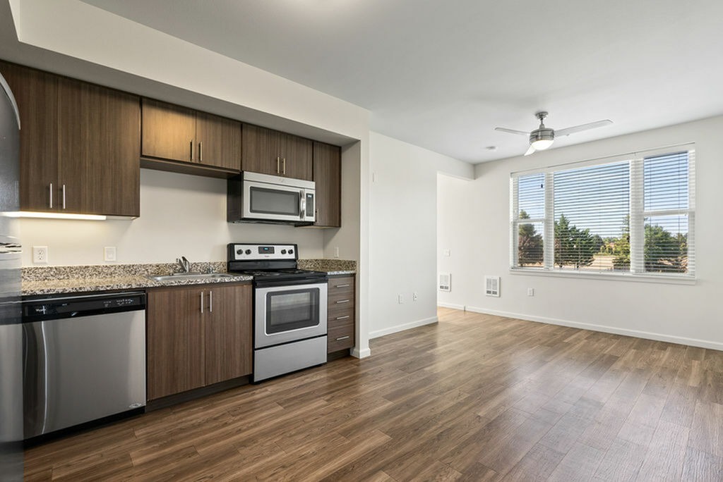
Parkside Lofts in Vancouver, WA offers stylish studio and one-bedroom apartments in the heart of the Columbia Tech Center. Each home features stainless steel appliances, quartz countertops, vinyl plank flooring, in-unit washer and dryer, and ceiling fans. The pet-friendly community offers modern amenities including a fitness center, clubhouse, outdoor fire pit, BBQ areas, covered parking, private bike storage, package lockers, controlled access, and complimentary Wi-Fi in common areas. Residents enjoy a dedicated on-site team, 24-hour emergency maintenance, and access to nearby trails, shopping, dining, and East Vancouver's premiere work, live, and play destination.
Parkside Lofts is an apartment community located in Clark County and the 98683 ZIP Code. This area is served by the Evergreen School District (Clark) attendance zone.
Unique Features
Fitness Center
Elevator
Clubhouse
Controlled Access
Recycling
Grill
Conference Rooms
Bicycle Storage
Washer/Dryer
Air Conditioning
Dishwasher
High Speed Internet Access
Hardwood Floors
Walk-In Closets
Granite Countertops
Microwave
The Bennington district, one of Vancouver's most eastern neighborhoods, exudes the shiny newness of a young neighborhood. Clean modern residences, groups of townhouses and gated communities with lush green lawns and landscaped properties make up the residential areas. Two major shopping centers service the neighborhood and foster self-sufficiency.
The satellite campus of Clark College in the Columbia Tech Center makes Bennington an education destination. The college draws students for degree completion, continuing education and cooking programs, and it drives the housing and retail development around it.
Located near the city's eastern limits, Bennington sits 12 miles to the southeast of downtown Vancouver. This suburban neighborhood is only 15 minutes away from the city's urban center.
Learn more about living in Bennington| Colleges & Universities | Distance | ||
|---|---|---|---|
| Colleges & Universities | Distance | ||
| Drive: | 14 min | 6.2 mi | |
| Drive: | 18 min | 9.2 mi | |
| Drive: | 20 min | 11.8 mi | |
| Drive: | 22 min | 12.1 mi |


Transportation options available in Vancouver include Mt Hood Avenue, located 8.6 miles from Parkside Lofts. Parkside Lofts is near Portland International, located 9.7 miles or 19 minutes away.
| Transit / Subway | Distance | ||
|---|---|---|---|
| Transit / Subway | Distance | ||
|
|
Drive: | 17 min | 8.6 mi |
|
|
Drive: | 17 min | 8.6 mi |
|
|
Drive: | 19 min | 9.8 mi |
|
|
Drive: | 24 min | 12.7 mi |
|
|
Drive: | 22 min | 13.3 mi |
| Commuter Rail | Distance | ||
|---|---|---|---|
| Commuter Rail | Distance | ||
|
|
Drive: | 20 min | 11.7 mi |
|
|
Drive: | 29 min | 18.0 mi |
|
|
Drive: | 36 min | 22.9 mi |
|
|
Drive: | 40 min | 25.8 mi |
|
|
Drive: | 42 min | 27.6 mi |
| Airports | Distance | ||
|---|---|---|---|
| Airports | Distance | ||
|
Portland International
|
Drive: | 19 min | 9.7 mi |
Time and distance from Parkside Lofts.
| Shopping Centers | Distance | ||
|---|---|---|---|
| Shopping Centers | Distance | ||
| Walk: | 8 min | 0.4 mi | |
| Walk: | 11 min | 0.6 mi | |
| Walk: | 12 min | 0.6 mi |
| Parks and Recreation | Distance | ||
|---|---|---|---|
| Parks and Recreation | Distance | ||
|
Pacific Community Park
|
Drive: | 3 min | 1.5 mi |
|
Fisher Basin Community Park
|
Drive: | 4 min | 1.7 mi |
|
Bella Vista Park
|
Drive: | 7 min | 2.3 mi |
|
Hearthwood Park
|
Drive: | 5 min | 2.3 mi |
|
LeRoy Haagen Memorial Park
|
Drive: | 7 min | 3.1 mi |
| Hospitals | Distance | ||
|---|---|---|---|
| Hospitals | Distance | ||
| Drive: | 10 min | 4.5 mi | |
| Drive: | 22 min | 12.4 mi | |
| Drive: | 24 min | 14.2 mi |
| Military Bases | Distance | ||
|---|---|---|---|
| Military Bases | Distance | ||
| Drive: | 20 min | 9.3 mi | |
| Drive: | 20 min | 10.4 mi |
What Are Walk Score®, Transit Score®, and Bike Score® Ratings?
Walk Score® measures the walkability of any address. Transit Score® measures access to public transit. Bike Score® measures the bikeability of any address.
What is a Sound Score Rating?
A Sound Score Rating aggregates noise caused by vehicle traffic, airplane traffic and local sources

17701 SE Mill Plain Blvd
Vancouver, WA 98683


