
Williamsburg
200 W Galbraith Rd,
Cincinnati, OH 45215
$900 - $2,659
Studio - 3 Beds
Bedrooms
1 - 3 bd
Bathrooms
1 - 2 ba
Square Feet
560 - 1,100 sq ft
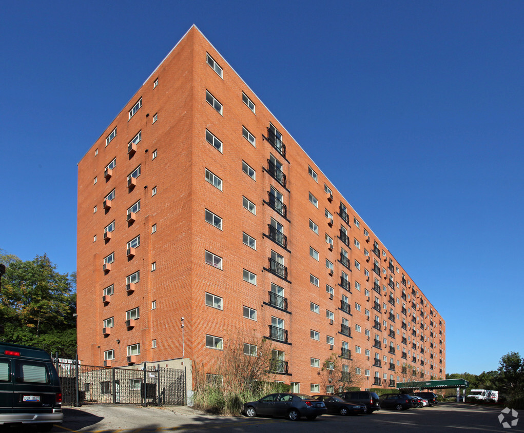
Distinctive living at affordable prices. Park Lane Apartments in Cincinnati, Ohio, offers one, two, three and four bedroom homes in a unique high-rise building. Whether you choose to spend the evening in our fitness center, cybercafe or community social room, you will always find something to do without ever leaving home. With covered parking and controlled access entry, our community has it all.
Distinctive living at affordable prices. Park Lane Apartments in Cincinnati, Ohio, offers one, two, three and four bedroom homes in a unique high-rise building. Whether you choose to spend the evening in our fitness center, cybercafe or community social room, you will always find something to do without ever leaving home. With covered parking and controlled access entry, our community has it all.
Park Lane is an apartment community located in Hamilton County and the 45229 ZIP Code. This area is served by the Cincinnati Public Schools attendance zone.
Unique Features
Fitness Center
Laundry Facilities
Elevator
Controlled Access
Air Conditioning
Dishwasher
High Speed Internet Access
Walk-In Closets
Tub/Shower
Disposal
Ceiling Fans
Smoke Free
Nicknamed "Cincinnati's Best-Kept Secret," Paddock Hills is about five miles away from Downtown Cincinnati and lies just north of Xavier University. Although Paddock Hills is one of the city’s smallest official neighborhoods, the area has plenty to offer. Along with its strong sense of community, Paddock Hills is best known for being home to Avon Fields Golf Course and Sugar n’ Spice, a long-standing brunch spot known for its colorful decorations and cartoon murals. Paddock Hills has an active neighborhood association and hosts community events like potlucks and block parties throughout the year.
This quaint neighborhood features a variety of Tudor Revival and Dutch Colonial houses along with brick apartments for rent, which are complemented by tree-lined-streets and cul de sacs.
Learn more about living in Paddock HillsCompare neighborhood and city base rent averages by bedroom.
| Paddock Hills | Cincinnati, OH | |
|---|---|---|
| Studio | - | $1,055 |
| 1 Bedroom | $874 | $1,132 |
| 2 Bedrooms | $1,224 | $1,407 |
| 3 Bedrooms | $1,503 | $1,689 |
| Colleges & Universities | Distance | ||
|---|---|---|---|
| Colleges & Universities | Distance | ||
| Walk: | 15 min | 0.8 mi | |
| Drive: | 8 min | 3.2 mi | |
| Drive: | 8 min | 3.3 mi | |
| Drive: | 14 min | 5.2 mi |


Transportation options available in Cincinnati include Findlay Market-Race Station, Race & Elder, located 4.6 miles from Park Lane. Park Lane is near Cincinnati/Northern Kentucky International, located 19.5 miles or 36 minutes away.
| Transit / Subway | Distance | ||
|---|---|---|---|
| Transit / Subway | Distance | ||
| Drive: | 12 min | 4.6 mi | |
| Drive: | 12 min | 4.7 mi | |
| Drive: | 12 min | 5.1 mi | |
| Drive: | 12 min | 5.4 mi | |
| Drive: | 13 min | 5.4 mi |
| Commuter Rail | Distance | ||
|---|---|---|---|
| Commuter Rail | Distance | ||
|
|
Drive: | 15 min | 8.7 mi |
| Airports | Distance | ||
|---|---|---|---|
| Airports | Distance | ||
|
Cincinnati/Northern Kentucky International
|
Drive: | 36 min | 19.5 mi |
Time and distance from Park Lane.
| Shopping Centers | Distance | ||
|---|---|---|---|
| Shopping Centers | Distance | ||
| Walk: | 21 min | 1.1 mi | |
| Drive: | 4 min | 1.2 mi | |
| Drive: | 5 min | 1.3 mi |
| Parks and Recreation | Distance | ||
|---|---|---|---|
| Parks and Recreation | Distance | ||
|
Avon Woods Natural Area/Preserve
|
Drive: | 3 min | 1.2 mi |
|
Cincinnati Zoo and Botanical Garden
|
Drive: | 8 min | 3.6 mi |
|
Trailside Nature Center
|
Drive: | 10 min | 3.7 mi |
|
Burnet Woods
|
Drive: | 10 min | 3.7 mi |
|
Caldwell Preserve
|
Drive: | 9 min | 3.9 mi |
| Hospitals | Distance | ||
|---|---|---|---|
| Hospitals | Distance | ||
| Drive: | 7 min | 2.5 mi | |
| Drive: | 7 min | 2.9 mi | |
| Drive: | 7 min | 2.9 mi |
| Military Bases | Distance | ||
|---|---|---|---|
| Military Bases | Distance | ||
| Drive: | 64 min | 49.4 mi | |
| Drive: | 70 min | 54.5 mi | |
| Drive: | 72 min | 57.8 mi |
What Are Walk Score®, Transit Score®, and Bike Score® Ratings?
Walk Score® measures the walkability of any address. Transit Score® measures access to public transit. Bike Score® measures the bikeability of any address.
What is a Sound Score Rating?
A Sound Score Rating aggregates noise caused by vehicle traffic, airplane traffic and local sources

4201 Victory Pky
Cincinnati, OH 45229


