Beacon
3510 Beacon Ave,
Fremont, CA 94538
$2,675 - $3,650
Studio - 2 Beds

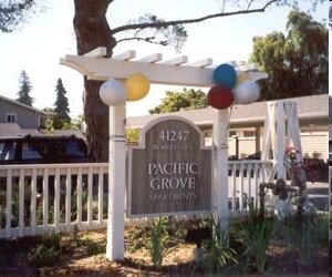
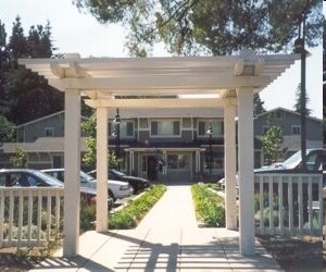
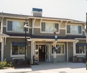
Meet your new apartment at Pacific Grove in Fremont, CA. The 94538 location is an ideal place to live. The professional leasing team is available to assist you in finding your new apartment. Schedule a time to check out the current floorplan options. Experience a better way of living at Pacific Grove. Contact or drop by to check the current floorplan availability today.
Pacific Grove is an apartment community located in Alameda County and the 94538 ZIP Code. This area is served by the Fremont Unified attendance zone.
Fitness Center
Clubhouse
Business Center
Gated
Irvington is a diverse, family-friendly suburb about two miles south of Downtown Fremont. Complemented by palm tree-lined streets, Irvington offers affordable to upscale rentals available in a variety of styles, including single-family homes and apartments. Great for families, Irvington is home to several excellent schools. Although residents certainly enjoy proximity to downtown’s abundant dining and shopping options, Irvington has a small commercial center in the middle of the neighborhood filled with authentic global eateries, boutiques, and grocery stores. This central area is also home to the Irvington Farmers Market and the Fremont Bay Saint Farmers Market. Irvington borders Central Park to the north, providing residents with a day of fun outdoors with its dynamic facilities that include a skate park, golf course, and water park.
Learn more about living in Irvington| Colleges & Universities | Distance | ||
|---|---|---|---|
| Colleges & Universities | Distance | ||
| Drive: | 7 min | 3.0 mi | |
| Drive: | 8 min | 4.0 mi | |
| Drive: | 17 min | 11.0 mi | |
| Drive: | 23 min | 15.7 mi |


Transportation options available in Fremont include Fremont Station, located 2.6 miles from Pacific Grove. Pacific Grove is near Norman Y Mineta San Jose International, located 15.1 miles or 21 minutes away, and Metro Oakland International, located 23.6 miles or 32 minutes away.
| Transit / Subway | Distance | ||
|---|---|---|---|
| Transit / Subway | Distance | ||
|
|
Drive: | 6 min | 2.6 mi |
|
|
Drive: | 7 min | 2.8 mi |
|
|
Drive: | 5 min | 2.8 mi |
|
|
Drive: | 15 min | 7.1 mi |
|
|
Drive: | 14 min | 9.8 mi |
| Commuter Rail | Distance | ||
|---|---|---|---|
| Commuter Rail | Distance | ||
| Drive: | 8 min | 3.6 mi | |
| Drive: | 8 min | 3.6 mi | |
| Drive: | 18 min | 12.7 mi | |
| Drive: | 17 min | 13.1 mi | |
| Drive: | 18 min | 13.2 mi |
| Airports | Distance | ||
|---|---|---|---|
| Airports | Distance | ||
|
Norman Y Mineta San Jose International
|
Drive: | 21 min | 15.1 mi |
|
Metro Oakland International
|
Drive: | 32 min | 23.6 mi |
Time and distance from Pacific Grove.
| Shopping Centers | Distance | ||
|---|---|---|---|
| Shopping Centers | Distance | ||
| Walk: | 2 min | 0.1 mi | |
| Walk: | 6 min | 0.3 mi | |
| Walk: | 7 min | 0.4 mi |
| Parks and Recreation | Distance | ||
|---|---|---|---|
| Parks and Recreation | Distance | ||
|
Central Park (Lake Elizabeth)
|
Drive: | 7 min | 2.7 mi |
|
Quarry Lakes Regional Recreation Area
|
Drive: | 10 min | 5.0 mi |
|
Niles Canyon Railway
|
Drive: | 10 min | 5.1 mi |
|
Alameda Creek Regional Trail
|
Drive: | 11 min | 5.2 mi |
|
Niles Community Park
|
Drive: | 12 min | 5.6 mi |
| Hospitals | Distance | ||
|---|---|---|---|
| Hospitals | Distance | ||
| Drive: | 5 min | 2.1 mi | |
| Drive: | 7 min | 2.9 mi |
| Military Bases | Distance | ||
|---|---|---|---|
| Military Bases | Distance | ||
| Drive: | 26 min | 17.8 mi |
What Are Walk Score®, Transit Score®, and Bike Score® Ratings?
Walk Score® measures the walkability of any address. Transit Score® measures access to public transit. Bike Score® measures the bikeability of any address.
What is a Sound Score Rating?
A Sound Score Rating aggregates noise caused by vehicle traffic, airplane traffic and local sources
41247 Roberts Ave
Fremont, CA 94538


