
Loyola Junction Phase I
6525 Ed Bluestein Blvd,
Austin, TX 78724
$1,305 - $2,076
1-2 Beds
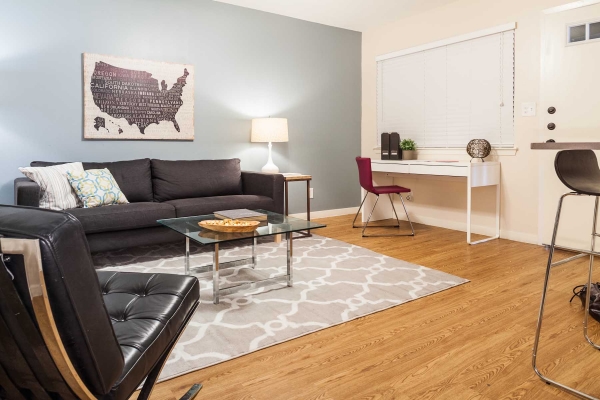

Historic Hyde Park. Complete interior & exterior remodel. VIRTUAL TOUR at www.caryprop.com or copy/paste link: 1 BEDROOM: https://my.matterport.com/show/?m=UtGETyDq1ac STUDIO: https://my.matterport.com/show/?m=GoCosmrGkTV Silestone countertops. Large walk-in closet. Vaulted ceilings in upstairs units. New appliances. Dishwasher. Washer/dryer in apartment. Recycling on site. Convenient to UT shuttle 5-10 minutes to UT & city bus lines, Central Market & the Triangle.
Metro 38 is an apartment community located in Travis County and the 78705 ZIP Code. This area is served by the Austin Independent School District attendance zone.
Unique Features
Washer/Dryer
Air Conditioning
Dishwasher
Hardwood Floors
First developed in 1891 as a streetcar suburb, Hyde Park has become one of the most densely-populated areas in the city. With many historic buildings in its two historic districts, the neighborhood enjoys a charming beauty, with sites like the Queen Anne style Col. Monroe M. Shipe House and the Elisabet Ney Museum.
Hyde Park sits directly north of the University of Texas at Austin, with I-35 running along the eastern border. On the west side, residents have easy access to a variety of shops, including Central Market, and the Heart Hospital of Austin. The university is home to four museums, including the Blanton Museum of Art. Sports fans can cheer on the Longhorns at nearby the Darrell K Royal-Texas Memorial Stadium.
Learn more about living in Hyde ParkCompare neighborhood and city base rent averages by bedroom.
| Hyde Park | Austin, TX | |
|---|---|---|
| Studio | $981 | $1,203 |
| 1 Bedroom | $1,133 | $1,386 |
| 2 Bedrooms | $1,504 | $1,803 |
| 3 Bedrooms | $1,962 | $2,396 |
| Colleges & Universities | Distance | ||
|---|---|---|---|
| Colleges & Universities | Distance | ||
| Drive: | 5 min | 1.6 mi | |
| Drive: | 6 min | 2.5 mi | |
| Drive: | 9 min | 3.9 mi | |
| Drive: | 13 min | 6.5 mi |


Transportation options available in Austin include M L King Jr Station, located 2.9 miles from Metro 38. Metro 38 is near Austin-Bergstrom International, located 12.7 miles or 25 minutes away.
| Transit / Subway | Distance | ||
|---|---|---|---|
| Transit / Subway | Distance | ||
| Drive: | 7 min | 2.9 mi | |
| Drive: | 7 min | 3.3 mi | |
| Drive: | 6 min | 3.4 mi | |
| Drive: | 6 min | 3.5 mi | |
| Drive: | 7 min | 3.8 mi |
| Commuter Rail | Distance | ||
|---|---|---|---|
| Commuter Rail | Distance | ||
|
|
Drive: | 9 min | 3.8 mi |
|
|
Drive: | 41 min | 34.0 mi |
|
|
Drive: | 43 min | 34.7 mi |
| Airports | Distance | ||
|---|---|---|---|
| Airports | Distance | ||
|
Austin-Bergstrom International
|
Drive: | 25 min | 12.7 mi |
Scores provided by
Traffic
-Airport
-Businesses
-Scores provided by
HowLoud What is a Sound Score Rating? A Sound Score Rating aggregates noise caused by vehicle traffic, airplane traffic and local sources. How It WorksTime and distance from Metro 38.
| Shopping Centers | Distance | ||
|---|---|---|---|
| Shopping Centers | Distance | ||
| Walk: | 6 min | 0.4 mi | |
| Walk: | 15 min | 0.8 mi | |
| Walk: | 17 min | 0.9 mi |
| Parks and Recreation | Distance | ||
|---|---|---|---|
| Parks and Recreation | Distance | ||
|
Elisabet Ney Museum
|
Walk: | 15 min | 0.8 mi |
|
Texas Memorial Museum
|
Drive: | 4 min | 1.5 mi |
|
Shoal Creek Greenbelt Park
|
Drive: | 4 min | 1.8 mi |
|
Thinkery
|
Drive: | 5 min | 2.3 mi |
|
Mayfield Park and Preserve
|
Drive: | 5 min | 2.5 mi |
| Hospitals | Distance | ||
|---|---|---|---|
| Hospitals | Distance | ||
| Walk: | 14 min | 0.7 mi | |
| Walk: | 15 min | 0.8 mi | |
| Drive: | 3 min | 1.2 mi |
| Military Bases | Distance | ||
|---|---|---|---|
| Military Bases | Distance | ||
| Drive: | 84 min | 68.9 mi | |
| Drive: | 90 min | 72.4 mi |
What Are Walk Score®, Transit Score®, and Bike Score® Ratings?
Walk Score® measures the walkability of any address. Transit Score® measures access to public transit. Bike Score® measures the bikeability of any address.
What is a Sound Score Rating?
A Sound Score Rating aggregates noise caused by vehicle traffic, airplane traffic and local sources.

102 W 38th St
Austin, TX 78705


