
Venue Residences
3688 Overland Ave,
Los Angeles, CA 90034
$2,625 - $5,650
Studio - 2 Beds
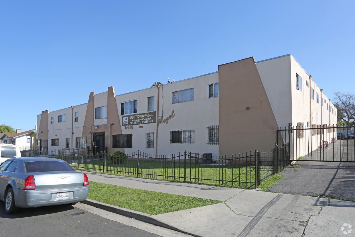

At Mazel in Los Angeles, CA, you've discovered your new home. The 10th Ave location in the 90043 Zip code of Los Angeles is a great place for you to move to. Schedule a time to see the available floorplan options. At this community, you'll experience access to a variety of amenities and features including: hardwood floors, high-speed internet access, and convenient on-site parking options. Experience a new standard at Mazel.
Mazel is an apartment community located in Los Angeles County and the 90043 ZIP Code. This area is served by the Los Angeles Unified Rocp School District attendance zone.
High Speed Internet Access
Hardwood Floors
Tile Floors
Ceiling Fans
Found in the Inglewood area of Los Angeles County, Park Mesa spans nearly three square miles between Downtown Los Angeles, which is 11 miles east, and Los Angeles International Airport, six miles west.
Park Mesa Heights hosts a variety of events and festivals. Inglewood's annual Dr. Martin Luther King Jr. Day Celebration brings residents out to commemorate, while the Slauson Indoor Swap Meet draws bargain hunters. With L.A. beaches lining the Pacific Ocean just eight miles away, Park Mesa Heights provides coastal breezes and easy access to sand and surf.
Learn more about living in Park Mesa HeightsCompare neighborhood and city base rent averages by bedroom.
| Park Mesa Heights | Los Angeles, CA | |
|---|---|---|
| Studio | $1,342 | $1,711 |
| 1 Bedroom | $1,447 | $2,183 |
| 2 Bedrooms | $1,925 | $3,016 |
| 3 Bedrooms | $2,211 | $4,340 |
| Colleges & Universities | Distance | ||
|---|---|---|---|
| Colleges & Universities | Distance | ||
| Drive: | 10 min | 5.0 mi | |
| Drive: | 10 min | 5.8 mi | |
| Drive: | 12 min | 5.9 mi | |
| Drive: | 11 min | 6.8 mi |


Transportation options available in Los Angeles include Hyde Park Station, located 0.7 mile from Mazel. Mazel is near Los Angeles International, located 6.4 miles or 13 minutes away, and Long Beach (Daugherty Field), located 20.0 miles or 29 minutes away.
| Transit / Subway | Distance | ||
|---|---|---|---|
| Transit / Subway | Distance | ||
| Walk: | 13 min | 0.7 mi | |
| Drive: | 3 min | 1.3 mi | |
| Drive: | 3 min | 1.9 mi | |
| Drive: | 3 min | 2.0 mi | |
| Drive: | 5 min | 2.4 mi |
| Commuter Rail | Distance | ||
|---|---|---|---|
| Commuter Rail | Distance | ||
|
|
Drive: | 16 min | 10.2 mi |
|
|
Drive: | 18 min | 10.4 mi |
|
|
Drive: | 23 min | 12.3 mi |
| Drive: | 20 min | 14.2 mi | |
|
|
Drive: | 23 min | 14.8 mi |
| Airports | Distance | ||
|---|---|---|---|
| Airports | Distance | ||
|
Los Angeles International
|
Drive: | 13 min | 6.4 mi |
|
Long Beach (Daugherty Field)
|
Drive: | 29 min | 20.0 mi |
Scores provided by
Traffic
-Airport
-Businesses
-Scores provided by
HowLoud What is a Sound Score Rating? A Sound Score Rating aggregates noise caused by vehicle traffic, airplane traffic and local sources. How It WorksTime and distance from Mazel.
| Shopping Centers | Distance | ||
|---|---|---|---|
| Shopping Centers | Distance | ||
| Walk: | 14 min | 0.7 mi | |
| Drive: | 4 min | 1.9 mi |
| Parks and Recreation | Distance | ||
|---|---|---|---|
| Parks and Recreation | Distance | ||
|
Natural History Museum of LA County
|
Drive: | 9 min | 5.0 mi |
|
Kenneth Hahn State Recreation Area
|
Drive: | 12 min | 5.0 mi |
|
Exposition Park Rose Garden
|
Drive: | 9 min | 5.1 mi |
|
California Science Center
|
Drive: | 10 min | 5.2 mi |
|
Augustus Hawkins Natural Park
|
Drive: | 10 min | 5.3 mi |
| Hospitals | Distance | ||
|---|---|---|---|
| Hospitals | Distance | ||
| Drive: | 7 min | 3.4 mi | |
| Drive: | 11 min | 6.6 mi | |
| Drive: | 12 min | 7.4 mi |
| Military Bases | Distance | ||
|---|---|---|---|
| Military Bases | Distance | ||
| Drive: | 13 min | 7.2 mi | |
| Drive: | 31 min | 21.9 mi | |
| Drive: | 34 min | 24.1 mi |
Pets Allowed In Unit Washer & Dryer Maintenance on site Heat Controlled Access Elevator
What Are Walk Score®, Transit Score®, and Bike Score® Ratings?
Walk Score® measures the walkability of any address. Transit Score® measures access to public transit. Bike Score® measures the bikeability of any address.
What is a Sound Score Rating?
A Sound Score Rating aggregates noise caused by vehicle traffic, airplane traffic and local sources.
6416 10th Ave
Los Angeles, CA 90043


