
19 East
19 E 19th St,
Bayonne, NJ 07002
$2,200 - $3,200 Total Monthly Price
Studio - 2 Beds
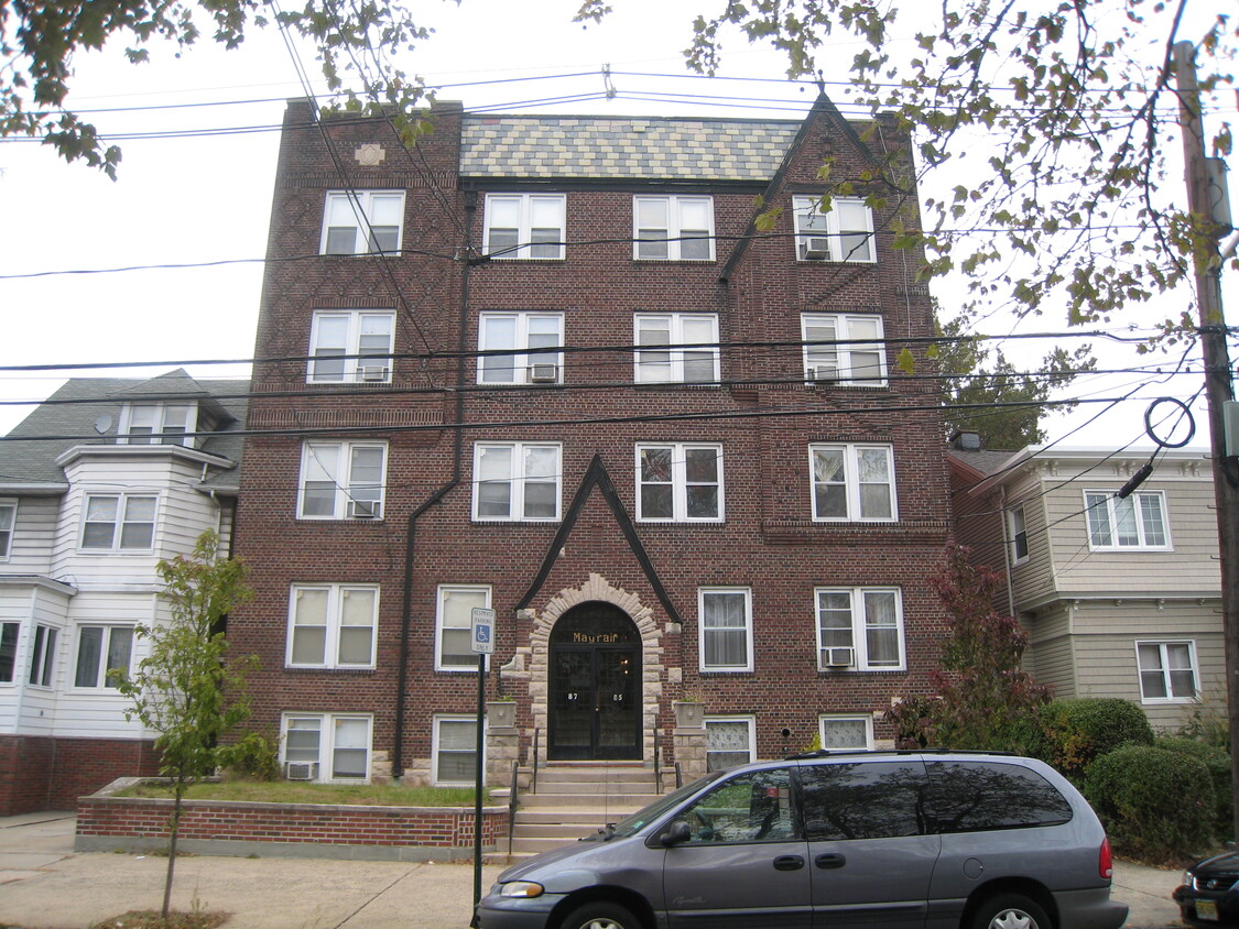
Welcome to the Mayfair Apartments, a charming four-story building that seamlessly blends classic elegance with modern comfort. With 25 beautifully designed residential apartments, this inviting community offers a unique living experience in the heart of Bayonne, New Jersey. The Mayfair Apartments features spacious layouts that cater to your lifestyle needs, whether you're a young professional, a growing family, or anyone in between. The building exudes a timeless character while providing essential modern amenities for today’s discerning residents. Enjoy easy access to local shops, dining, and public transportation, making your daily commute a breeze. Experience the warmth of a vibrant neighborhood while relishing the comfort of your new home at the Mayfair Apartments. Come explore your future residence—where charm meets convenience!
Mayfair Apartments is an apartment community located in Hudson County and the 07002 ZIP Code. This area is served by the Bayonne School District attendance zone.
Dishwasher
High Speed Internet Access
Hardwood Floors
Yard
Bayonne sits on a narrow peninsula between Newark Bay and New York Harbor, giving it a geography that shapes nearly everything about daily life here. The city occupies just 12 square miles, yet it carries a distinct identity rooted in maritime history, close-knit blocks, and an increasingly sought-after position within the broader New York metro. A well-connected Hudson-Bergen Light Rail system with stops at 8th, 22nd, 34th, and 45th Streets makes Jersey City and Hoboken straightforward commutes, while the Bayonne Bridge links the city to Staten Island.
Neighborhoods range from the historic streets of Bergen Point near the southern tip to the waterfront development at Peninsula at Bayonne Harbor, where the former Military Ocean Terminal has been reimagined as a residential and recreational destination. The Uptown area around 34th Street anchors everyday commerce, while Broadway serves as the city's main corridor throughout.
Learn more about living in Bayonne| Colleges & Universities | Distance | ||
|---|---|---|---|
| Colleges & Universities | Distance | ||
| Drive: | 8 min | 3.5 mi | |
| Drive: | 10 min | 4.8 mi | |
| Drive: | 11 min | 5.5 mi | |
| Drive: | 18 min | 7.7 mi |


Transportation options available in Bayonne include 34Th Street, located 0.6 mile from Mayfair Apartments. Mayfair Apartments is near Newark Liberty International, located 6.5 miles or 11 minutes away, and LaGuardia, located 18.9 miles or 37 minutes away.
| Transit / Subway | Distance | ||
|---|---|---|---|
| Transit / Subway | Distance | ||
|
|
Walk: | 12 min | 0.6 mi |
|
|
Drive: | 3 min | 1.5 mi |
| Drive: | 3 min | 1.5 mi | |
|
|
Drive: | 5 min | 2.4 mi |
|
|
Drive: | 5 min | 2.5 mi |
| Commuter Rail | Distance | ||
|---|---|---|---|
| Commuter Rail | Distance | ||
|
|
Drive: | 20 min | 8.2 mi |
|
|
Drive: | 16 min | 8.3 mi |
|
|
Drive: | 20 min | 8.5 mi |
|
|
Drive: | 20 min | 8.9 mi |
|
|
Drive: | 20 min | 10.7 mi |
| Airports | Distance | ||
|---|---|---|---|
| Airports | Distance | ||
|
Newark Liberty International
|
Drive: | 11 min | 6.5 mi |
|
LaGuardia
|
Drive: | 37 min | 18.9 mi |
Scores provided by
Traffic
ActiveAirport
ActiveBusinesses
ActiveScores provided by
HowLoud What is a Sound Score Rating? A Sound Score Rating aggregates noise caused by vehicle traffic, airplane traffic and local sources. How It WorksTime and distance from Mayfair Apartments.
| Shopping Centers | Distance | ||
|---|---|---|---|
| Shopping Centers | Distance | ||
| Walk: | 16 min | 0.9 mi | |
| Drive: | 4 min | 1.1 mi | |
| Drive: | 5 min | 1.4 mi |
| Parks and Recreation | Distance | ||
|---|---|---|---|
| Parks and Recreation | Distance | ||
|
G. Thomas DiDomenico Park
|
Drive: | 3 min | 1.2 mi |
|
Stephen Gregg Park
|
Drive: | 5 min | 1.6 mi |
|
Faber Park
|
Drive: | 9 min | 4.4 mi |
|
Snug Harbor Cultural Center & Botanical Garden
|
Drive: | 14 min | 6.7 mi |
|
Staten Island Children's Museum
|
Drive: | 14 min | 6.7 mi |
| Hospitals | Distance | ||
|---|---|---|---|
| Hospitals | Distance | ||
| Walk: | 11 min | 0.6 mi | |
| Drive: | 11 min | 5.3 mi | |
| Drive: | 14 min | 6.6 mi |
| Military Bases | Distance | ||
|---|---|---|---|
| Military Bases | Distance | ||
| Drive: | 6 min | 2.0 mi | |
| Drive: | 21 min | 8.5 mi | |
| Drive: | 21 min | 11.0 mi |
What Are Walk Score®, Transit Score®, and Bike Score® Ratings?
Walk Score® measures the walkability of any address. Transit Score® measures access to public transit. Bike Score® measures the bikeability of any address.
What is a Sound Score Rating?
A Sound Score Rating aggregates noise caused by vehicle traffic, airplane traffic and local sources.

85-87 W 32nd St
Bayonne, NJ 07002


