
Williamsburg
200 W Galbraith Rd,
Cincinnati, OH 45215
$843 - $2,791
Studio - 3 Beds

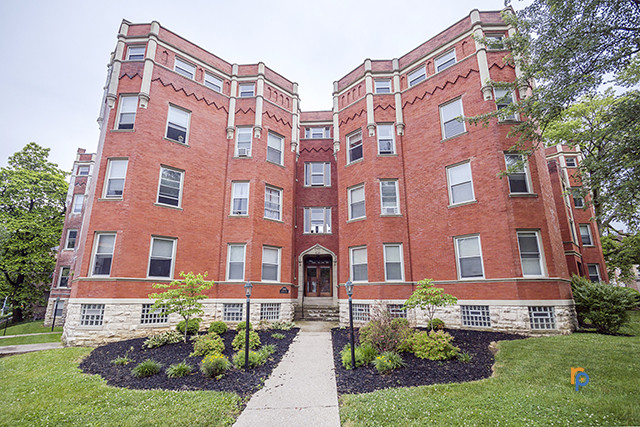
OFF STREET PARKING INCLUDED! The Maplewood is located in the historic Clifton gaslight district of Cincinnati, on the corner of Telford and Bryant Ave’s. This quiet, tree-lined street features the original gaslights and is just steps from the popular Ludlow business district. It was built in 1905 by the Emery family, Cincinnati's preeminent builders. Walking distance to University of Cincinnati, restaurants, shopping, library, coffee houses and much more. Close to hospitals. Preeminent businesses include the Esquire Theatre, Graeter's, Ambar India, Dewey's Pizza and many shops. The apartments include full amenities and expansive layouts, with hardwood floors, high, beamed ceilings, and spacious room sizes.
Maplewood-3440 Telford is an apartment community located in Hamilton County and the 45220 ZIP Code. This area is served by the Cincinnati Public Schools attendance zone.
Unique Features
Air Conditioning
Hardwood Floors
Refrigerator
Crown Molding
In Clifton there’s plenty to do and see. The rolling hills, lush parks and green spaces, hip shopping, and affordable apartments create a vibrancy in Clifton that can’t be ignored.
In addition to its active art scene, the neighborhood is encompassing of Mount Storm Park, Edgewood Grove Park, and the Cincinnati State Technical and Community College. Locals enjoy the direct access to Interstate 75, making commutes in and around the city a breeze.
Clifton is just north of the 90-acre Burnet Woods Park and the University of Cincinnati campus. When you have a craving for something sweet or savory, head on over to the Clifton Gaslight District for every kind of cuisine imaginable. Clifton sits atop a hill overlooking the Northside, and Ludlow Avenue has been dubbed Cincinnati’s first “Main Street.
Learn more about living in CliftonCompare neighborhood and city base rent averages by bedroom.
| Clifton | Cincinnati, OH | |
|---|---|---|
| Studio | $825 | $1,073 |
| 1 Bedroom | $962 | $1,135 |
| 2 Bedrooms | $1,353 | $1,424 |
| 3 Bedrooms | $1,382 | $1,731 |
| Colleges & Universities | Distance | ||
|---|---|---|---|
| Colleges & Universities | Distance | ||
| Drive: | 3 min | 1.3 mi | |
| Drive: | 4 min | 1.4 mi | |
| Drive: | 6 min | 1.7 mi | |
| Drive: | 9 min | 3.1 mi |


Transportation options available in Cincinnati include Findlay Market-Race Station - Race & Elder, located 2.4 miles from Maplewood-3440 Telford. Maplewood-3440 Telford is near Cincinnati/Northern Kentucky International, located 17.9 miles or 32 minutes away.
| Transit / Subway | Distance | ||
|---|---|---|---|
| Transit / Subway | Distance | ||
| Drive: | 6 min | 2.4 mi | |
| Drive: | 6 min | 2.5 mi | |
| Drive: | 7 min | 2.5 mi | |
| Drive: | 7 min | 2.6 mi | |
| Drive: | 8 min | 2.9 mi |
| Commuter Rail | Distance | ||
|---|---|---|---|
| Commuter Rail | Distance | ||
|
|
Drive: | 8 min | 3.8 mi |
| Airports | Distance | ||
|---|---|---|---|
| Airports | Distance | ||
|
Cincinnati/Northern Kentucky International
|
Drive: | 32 min | 17.9 mi |
Scores provided by
Traffic
ActiveAirport
CalmBusinesses
ActiveScores provided by
HowLoud What is a Sound Score Rating? A Sound Score Rating aggregates noise caused by vehicle traffic, airplane traffic and local sources. How It WorksTime and distance from Maplewood-3440 Telford.
| Shopping Centers | Distance | ||
|---|---|---|---|
| Shopping Centers | Distance | ||
| Drive: | 3 min | 1.1 mi | |
| Drive: | 4 min | 1.5 mi | |
| Drive: | 6 min | 2.5 mi |
| Parks and Recreation | Distance | ||
|---|---|---|---|
| Parks and Recreation | Distance | ||
|
Burnet Woods
|
Walk: | 8 min | 0.5 mi |
|
Cincinnati Zoo and Botanical Garden
|
Walk: | 14 min | 0.7 mi |
|
Trailside Nature Center
|
Drive: | 3 min | 1.2 mi |
|
William H. Taft National Historic Site
|
Drive: | 7 min | 2.5 mi |
|
Buttercup Valley
|
Drive: | 8 min | 2.9 mi |
| Hospitals | Distance | ||
|---|---|---|---|
| Hospitals | Distance | ||
| Walk: | 9 min | 0.5 mi | |
| Drive: | 4 min | 1.4 mi | |
| Drive: | 5 min | 1.8 mi |
| Military Bases | Distance | ||
|---|---|---|---|
| Military Bases | Distance | ||
| Drive: | 67 min | 50.9 mi | |
| Drive: | 73 min | 56.0 mi | |
| Drive: | 76 min | 59.3 mi |
What Are Walk Score®, Transit Score®, and Bike Score® Ratings?
Walk Score® measures the walkability of any address. Transit Score® measures access to public transit. Bike Score® measures the bikeability of any address.
What is a Sound Score Rating?
A Sound Score Rating aggregates noise caused by vehicle traffic, airplane traffic and local sources.
3440 Telford St
Cincinnati, OH 45220


