
Vanguard
1001 Marshall Ave,
Cincinnati, OH 45219
Studio - 5 Beds $683 - $1,479
Bedrooms
1 bd
Bathrooms
1 ba
Square Feet
430 sq ft
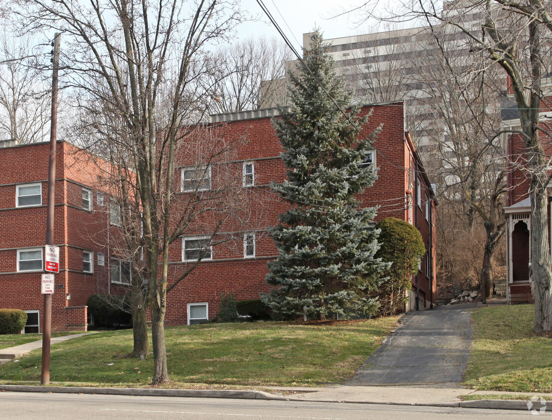
Located in the heart of Cincinnati’s vibrant Gaslight District, 922-926 Ludlow Avenue offers comfortable, pet-friendly apartment homes in a well-maintained multi-unit building. Residents enjoy easy access to the eclectic shops, restaurants, and entertainment venues that make Ludlow Avenue a sought-after destination. This community is conveniently close to the University of Cincinnati, Cincinnati State, and Clifton Market, with public transportation and major roadways like Martin Luther King Drive and Clifton Avenue nearby for easy commuting to Downtown Cincinnati, Over-the-Rhine, and other neighborhoods. With pet-friendly policies welcoming most cats and dogs, these apartments provide a welcoming home in one of Cincinnati’s most historic and walkable neighborhoods.
Located in the heart of Cincinnati’s vibrant Gaslight District, 922-926 Ludlow Avenue offers comfortable, pet-friendly apartment homes in a well-maintained multi-unit building. Residents enjoy easy access to the eclectic shops, restaurants, and entertainment venues that make Ludlow Avenue a sought-after destination. This community is conveniently close to the University of Cincinnati, Cincinnati State, and Clifton Market, with public transportation and major roadways like Martin Luther King Drive and Clifton Avenue nearby for easy commuting to Downtown Cincinnati, Over-the-Rhine, and other neighborhoods. With pet-friendly policies welcoming most cats and dogs, these apartments provide a welcoming home in one of Cincinnati’s most historic and walkable neighborhoods.
Ludlow 922-926 is an apartment community located in Hamilton County and the 45220 ZIP Code. This area is served by the Cincinnati Public Schools attendance zone.
In Clifton there’s plenty to do and see. The rolling hills, lush parks and green spaces, hip shopping, and affordable apartments create a vibrancy in Clifton that can’t be ignored.
In addition to its active art scene, the neighborhood is encompassing of Mount Storm Park, Edgewood Grove Park, and the Cincinnati State Technical and Community College. Locals enjoy the direct access to Interstate 75, making commutes in and around the city a breeze.
Clifton is just north of the 90-acre Burnet Woods Park and the University of Cincinnati campus. When you have a craving for something sweet or savory, head on over to the Clifton Gaslight District for every kind of cuisine imaginable. Clifton sits atop a hill overlooking the Northside, and Ludlow Avenue has been dubbed Cincinnati’s first “Main Street.
Learn more about living in Clifton| Colleges & Universities | Distance | ||
|---|---|---|---|
| Colleges & Universities | Distance | ||
| Walk: | 5 min | 0.3 mi | |
| Drive: | 5 min | 2.1 mi | |
| Drive: | 6 min | 2.1 mi | |
| Drive: | 10 min | 3.7 mi |


Transportation options available in Cincinnati include Findlay Market-Race Station, Race & Elder, located 3.1 miles from Ludlow 922-926. Ludlow 922-926 is near Cincinnati/Northern Kentucky International, located 18.4 miles or 34 minutes away.
| Transit / Subway | Distance | ||
|---|---|---|---|
| Transit / Subway | Distance | ||
| Drive: | 8 min | 3.1 mi | |
| Drive: | 8 min | 3.4 mi | |
| Drive: | 9 min | 3.7 mi | |
| Drive: | 9 min | 3.8 mi | |
| Drive: | 9 min | 3.9 mi |
| Commuter Rail | Distance | ||
|---|---|---|---|
| Commuter Rail | Distance | ||
|
|
Drive: | 9 min | 4.3 mi |
| Airports | Distance | ||
|---|---|---|---|
| Airports | Distance | ||
|
Cincinnati/Northern Kentucky International
|
Drive: | 34 min | 18.4 mi |
Time and distance from Ludlow 922-926.
| Shopping Centers | Distance | ||
|---|---|---|---|
| Shopping Centers | Distance | ||
| Drive: | 4 min | 1.7 mi | |
| Drive: | 5 min | 1.7 mi | |
| Drive: | 7 min | 3.0 mi |
| Parks and Recreation | Distance | ||
|---|---|---|---|
| Parks and Recreation | Distance | ||
|
Burnet Woods
|
Drive: | 4 min | 1.3 mi |
|
Buttercup Valley
|
Drive: | 5 min | 1.9 mi |
|
Cincinnati Zoo and Botanical Garden
|
Drive: | 5 min | 2.0 mi |
|
Trailside Nature Center
|
Drive: | 5 min | 2.0 mi |
|
William H. Taft National Historic Site
|
Drive: | 9 min | 3.3 mi |
| Hospitals | Distance | ||
|---|---|---|---|
| Hospitals | Distance | ||
| Drive: | 4 min | 1.3 mi | |
| Drive: | 6 min | 2.4 mi | |
| Drive: | 7 min | 2.6 mi |
| Military Bases | Distance | ||
|---|---|---|---|
| Military Bases | Distance | ||
| Drive: | 68 min | 51.5 mi | |
| Drive: | 74 min | 56.5 mi | |
| Drive: | 77 min | 59.8 mi |
What Are Walk Score®, Transit Score®, and Bike Score® Ratings?
Walk Score® measures the walkability of any address. Transit Score® measures access to public transit. Bike Score® measures the bikeability of any address.
What is a Sound Score Rating?
A Sound Score Rating aggregates noise caused by vehicle traffic, airplane traffic and local sources
922 Ludlow Ave
Cincinnati, OH 45220


