
The Vitagraph
1277 E 14th St,
Brooklyn, NY 11230
$3,424 - $4,304
2-3 Beds
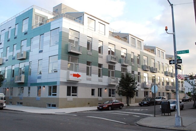

Come home to Lofts on Irving in Brooklyn, NY. You'll find this community at 342 Eldert St. in the 11237 area of Brooklyn. The professional leasing team is eager for your visit. Enjoy a great selection of amenities like convenient on-site parking options, smoke-free options, and a doorman. So get a head start on your move. Contact or stop by the Lofts on Irving leasing office to schedule a tour.
Lofts on Irving is an apartment community located in Kings County and the 11237 ZIP Code. This area is served by the New York City Geographic District #32 attendance zone.
Fitness Center
Elevator
Doorman
Roof Terrace
Air Conditioning
Loft Layout
Hardwood Floors
Refrigerator
Neighboring Williamsburg to the east, Bushwick is a vibrant Brooklyn neighborhood known for its incredible street art, local shops, and diverse cuisine. Bushwick has historically served as a haven for immigrants, and now attracts scores of creative types to its many galleries and converted loft spaces.
In addition to a host of new local businesses, Bushwick offers residents exciting nightlife options and easy subway access. Colorful apartment buildings line quiet residential streets in Bushwick as well, providing plenty of rental opportunities to the community. Numerous neighborhood parks offer a tranquil reprieve from the big-city bustle.
Learn more about living in BushwickCompare neighborhood and city base rent averages by bedroom.
| Bushwick | Brooklyn, NY | |
|---|---|---|
| Studio | $2,044 | $2,680 |
| 1 Bedroom | $1,715 | $3,031 |
| 2 Bedrooms | $2,011 | $3,947 |
| 3 Bedrooms | $2,583 | $4,907 |
| Colleges & Universities | Distance | ||
|---|---|---|---|
| Colleges & Universities | Distance | ||
| Drive: | 11 min | 4.0 mi | |
| Drive: | 12 min | 4.3 mi | |
| Drive: | 12 min | 4.5 mi | |
| Drive: | 13 min | 5.6 mi |


Transportation options available in Brooklyn include Halsey Street (L Line), located 0.2 mile from Lofts on Irving. Lofts on Irving is near LaGuardia, located 7.6 miles or 18 minutes away, and John F Kennedy International, located 10.6 miles or 18 minutes away.
| Transit / Subway | Distance | ||
|---|---|---|---|
| Transit / Subway | Distance | ||
|
|
Walk: | 4 min | 0.2 mi |
|
|
Walk: | 11 min | 0.6 mi |
|
|
Walk: | 12 min | 0.6 mi |
|
|
Drive: | 3 min | 1.2 mi |
|
|
Drive: | 3 min | 1.2 mi |
| Commuter Rail | Distance | ||
|---|---|---|---|
| Commuter Rail | Distance | ||
|
|
Drive: | 4 min | 1.9 mi |
|
|
Drive: | 9 min | 3.3 mi |
|
|
Drive: | 10 min | 4.1 mi |
|
|
Drive: | 13 min | 4.7 mi |
|
|
Drive: | 12 min | 4.9 mi |
| Airports | Distance | ||
|---|---|---|---|
| Airports | Distance | ||
|
LaGuardia
|
Drive: | 18 min | 7.6 mi |
|
John F Kennedy International
|
Drive: | 18 min | 10.6 mi |
Scores provided by
Traffic
-Airport
-Businesses
-Scores provided by
HowLoud What is a Sound Score Rating? A Sound Score Rating aggregates noise caused by vehicle traffic, airplane traffic and local sources. How It WorksTime and distance from Lofts on Irving.
| Shopping Centers | Distance | ||
|---|---|---|---|
| Shopping Centers | Distance | ||
| Walk: | 11 min | 0.6 mi | |
| Drive: | 6 min | 2.3 mi |
| Parks and Recreation | Distance | ||
|---|---|---|---|
| Parks and Recreation | Distance | ||
|
Highland Park and Ridgewood Reservoir
|
Drive: | 3 min | 1.2 mi |
|
Maria Hernandez Park
|
Drive: | 5 min | 1.5 mi |
|
Highland Park Childrens Garden
|
Drive: | 5 min | 2.1 mi |
|
Betsy Head Memorial Playground
|
Drive: | 7 min | 2.5 mi |
|
St. John's Park
|
Drive: | 8 min | 2.6 mi |
| Hospitals | Distance | ||
|---|---|---|---|
| Hospitals | Distance | ||
| Drive: | 5 min | 1.5 mi | |
| Drive: | 7 min | 2.3 mi | |
| Drive: | 7 min | 2.6 mi |
| Military Bases | Distance | ||
|---|---|---|---|
| Military Bases | Distance | ||
| Drive: | 24 min | 8.6 mi | |
| Drive: | 19 min | 9.4 mi | |
| Drive: | 28 min | 10.9 mi |
What Are Walk Score®, Transit Score®, and Bike Score® Ratings?
Walk Score® measures the walkability of any address. Transit Score® measures access to public transit. Bike Score® measures the bikeability of any address.
What is a Sound Score Rating?
A Sound Score Rating aggregates noise caused by vehicle traffic, airplane traffic and local sources.

342 Eldert St
Brooklyn, NY 11237


