
-
Monthly Rent
$1,050 - $1,200
-
Bedrooms
2 bd
-
Bathrooms
1 ba
-
Square Feet
820 - 900 sq ft
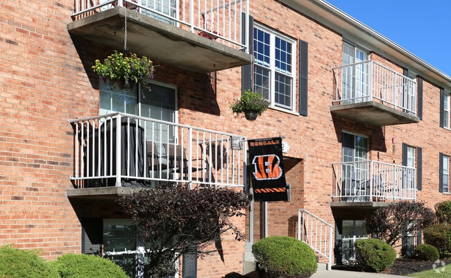
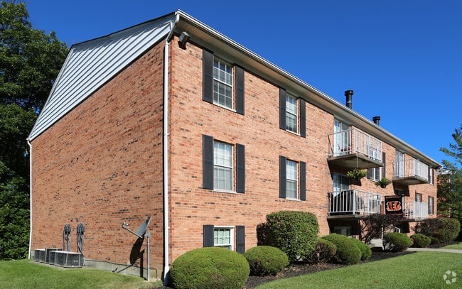
Here at Lee’s Crossing, we want you to be happy. Our residents are very important to us and it is our goal to provide them with a wonderful home and do that with excellence. To us, excellence means having the friendly service of a prompt and professional management team, speedy completion of maintenance requests, beautifully managed grounds, outstanding amenities and much more. We strive to do all that we can to make your life as comfortable and stress-free as possible. Lee's Crossing has a fantastic location. With being less than a mile from I-74, you will be just minutes from major shopping, downtown nightlife and really, the whole city! We are within walking distance to Kroger, various restaurants and multiple bus stops. If you're not looking to go out and about, residents can enjoy the basketball court, racquetball court, clubhouse, fitness center and swimming pool which are all conveniently located on the premises. Lee's Crossing provides the three essentials to a great home: convenience, comfort and great service. We believe that once you're here, you will feel right at home!
Highlights
- Basketball Court
- Tennis Court
- Den
- Yard
- High Ceilings
- Pool
- Walk-In Closets
- Controlled Access
- Fireplace
Pricing & Floor Plans
Fees and Policies
The fees listed below are community-provided and may exclude utilities or add-ons. All payments are made directly to the property and are non-refundable unless otherwise specified.
-
One-Time Basics
-
Due at Application
-
Application Fee Per ApplicantCharged per applicant.$25
-
-
Due at Move-In
-
Administrative FeeCharged per unit.$0
-
-
Due at Application
-
Surface Lot
Property Fee Disclaimer: Based on community-supplied data and independent market research. Subject to change without notice. May exclude fees for mandatory or optional services and usage-based utilities.
Details
Utilities Included
-
Trash Removal
Lease Options
-
12 mo
Property Information
-
Built in 1987
-
276 units/3 stories
About Lee's Crossing
Here at Lee’s Crossing, we want you to be happy. Our residents are very important to us and it is our goal to provide them with a wonderful home and do that with excellence. To us, excellence means having the friendly service of a prompt and professional management team, speedy completion of maintenance requests, beautifully managed grounds, outstanding amenities and much more. We strive to do all that we can to make your life as comfortable and stress-free as possible. Lee's Crossing has a fantastic location. With being less than a mile from I-74, you will be just minutes from major shopping, downtown nightlife and really, the whole city! We are within walking distance to Kroger, various restaurants and multiple bus stops. If you're not looking to go out and about, residents can enjoy the basketball court, racquetball court, clubhouse, fitness center and swimming pool which are all conveniently located on the premises. Lee's Crossing provides the three essentials to a great home: convenience, comfort and great service. We believe that once you're here, you will feel right at home!
Lee's Crossing is an apartment community located in Hamilton County and the 45239 ZIP Code. This area is served by the Cincinnati Public Schools attendance zone.
Unique Features
- Beautiful Wooded Views
- Clubhouse With Party Room
- Garage
- Indoor Racquetball Court
- Nautilus Fitness Center
- Some have woodburning fireplace
- Storage Locker in Building
- Swimming Pool With Sundeck
- Well Lit Neighborhood With Street- Lamps
Community Amenities
Pool
Fitness Center
Laundry Facilities
Clubhouse
- Package Service
- Laundry Facilities
- Controlled Access
- Maintenance on site
- Property Manager on Site
- Online Services
- Clubhouse
- Lounge
- Storage Space
- Walk-Up
- Fitness Center
- Pool
- Basketball Court
- Racquetball Court
- Tennis Court
- Sundeck
Apartment Features
Washer/Dryer
Air Conditioning
Dishwasher
High Speed Internet Access
Walk-In Closets
Yard
Refrigerator
Wi-Fi
Indoor Features
- High Speed Internet Access
- Wi-Fi
- Washer/Dryer
- Air Conditioning
- Heating
- Ceiling Fans
- Cable Ready
- Trash Compactor
- Storage Space
- Tub/Shower
- Fireplace
- Intercom
Kitchen Features & Appliances
- Dishwasher
- Disposal
- Eat-in Kitchen
- Kitchen
- Oven
- Range
- Refrigerator
Model Details
- Carpet
- Vinyl Flooring
- Dining Room
- High Ceilings
- Family Room
- Den
- Vaulted Ceiling
- Views
- Walk-In Closets
- Double Pane Windows
- Window Coverings
- Balcony
- Patio
- Yard
Located about nine miles north of Downtown Cincinnati, Monfort Heights East provides residents with a suburban setting without being too far to enjoy the amenities of the city. Monfort Heights East has a variety of affordable apartments available for rent. The area has good schools, parks, and access to plenty of restaurants, grocers, and other establishments along North Bend Road. Access to Interstate 74, Route 52, and Route 27 allow for easy travel into neighboring communities and into the heart of Cincinnati. If you’re seeking convenience, affordability, and a quiet atmosphere, Monfort Heights Easts is a great choice.
Learn more about living in Monfort Heights East- Package Service
- Laundry Facilities
- Controlled Access
- Maintenance on site
- Property Manager on Site
- Online Services
- Clubhouse
- Lounge
- Storage Space
- Walk-Up
- Sundeck
- Fitness Center
- Pool
- Basketball Court
- Racquetball Court
- Tennis Court
- Beautiful Wooded Views
- Clubhouse With Party Room
- Garage
- Indoor Racquetball Court
- Nautilus Fitness Center
- Some have woodburning fireplace
- Storage Locker in Building
- Swimming Pool With Sundeck
- Well Lit Neighborhood With Street- Lamps
- High Speed Internet Access
- Wi-Fi
- Washer/Dryer
- Air Conditioning
- Heating
- Ceiling Fans
- Cable Ready
- Trash Compactor
- Storage Space
- Tub/Shower
- Fireplace
- Intercom
- Dishwasher
- Disposal
- Eat-in Kitchen
- Kitchen
- Oven
- Range
- Refrigerator
- Carpet
- Vinyl Flooring
- Dining Room
- High Ceilings
- Family Room
- Den
- Vaulted Ceiling
- Views
- Walk-In Closets
- Double Pane Windows
- Window Coverings
- Balcony
- Patio
- Yard
| Monday | 10am - 6pm |
|---|---|
| Tuesday | 10am - 6pm |
| Wednesday | 10am - 6pm |
| Thursday | 10am - 6pm |
| Friday | 10am - 5pm |
| Saturday | Closed |
| Sunday | Closed |
| Colleges & Universities | Distance | ||
|---|---|---|---|
| Colleges & Universities | Distance | ||
| Drive: | 14 min | 6.8 mi | |
| Drive: | 14 min | 8.1 mi | |
| Drive: | 15 min | 8.6 mi | |
| Drive: | 20 min | 8.6 mi |


View GreatSchools Rating Methodology
Data provided by GreatSchools.org © 2026. All rights reserved.
Transportation options available in Cincinnati include Brewery District Station - Elm & Henry, located 8.9 miles from Lee's Crossing. Lee's Crossing is near Cincinnati/Northern Kentucky International, located 22.9 miles or 38 minutes away.
| Transit / Subway | Distance | ||
|---|---|---|---|
| Transit / Subway | Distance | ||
| Drive: | 15 min | 8.9 mi | |
| Drive: | 15 min | 8.9 mi | |
| Drive: | 15 min | 9.0 mi | |
| Drive: | 15 min | 9.1 mi | |
| Drive: | 15 min | 9.2 mi |
| Commuter Rail | Distance | ||
|---|---|---|---|
| Commuter Rail | Distance | ||
|
|
Drive: | 14 min | 8.8 mi |
| Airports | Distance | ||
|---|---|---|---|
| Airports | Distance | ||
|
Cincinnati/Northern Kentucky International
|
Drive: | 38 min | 22.9 mi |
Scores provided by
Traffic
BusyAirport
CalmBusinesses
CalmScores provided by
HowLoud What is a Sound Score Rating? A Sound Score Rating aggregates noise caused by vehicle traffic, airplane traffic and local sources. How It WorksTime and distance from Lee's Crossing.
| Shopping Centers | Distance | ||
|---|---|---|---|
| Shopping Centers | Distance | ||
| Walk: | 6 min | 0.3 mi | |
| Walk: | 9 min | 0.5 mi | |
| Walk: | 13 min | 0.7 mi |
| Parks and Recreation | Distance | ||
|---|---|---|---|
| Parks and Recreation | Distance | ||
|
Mt. Airy Forest
|
Drive: | 4 min | 1.6 mi |
|
Farbach-Werner Nature Preserve
|
Drive: | 9 min | 4.1 mi |
|
LaBoiteaux Woods
|
Drive: | 10 min | 4.2 mi |
|
Buttercup Valley
|
Drive: | 12 min | 4.7 mi |
|
Mitchell Memorial Forest
|
Drive: | 13 min | 6.9 mi |
| Hospitals | Distance | ||
|---|---|---|---|
| Hospitals | Distance | ||
| Drive: | 4 min | 1.4 mi | |
| Drive: | 12 min | 7.4 mi | |
| Drive: | 15 min | 8.6 mi |
| Military Bases | Distance | ||
|---|---|---|---|
| Military Bases | Distance | ||
| Drive: | 74 min | 56.6 mi | |
| Drive: | 80 min | 61.6 mi | |
| Drive: | 82 min | 64.9 mi |
Lee's Crossing Photos
-
Lee's Crossing
-
-
Primary Photo
-
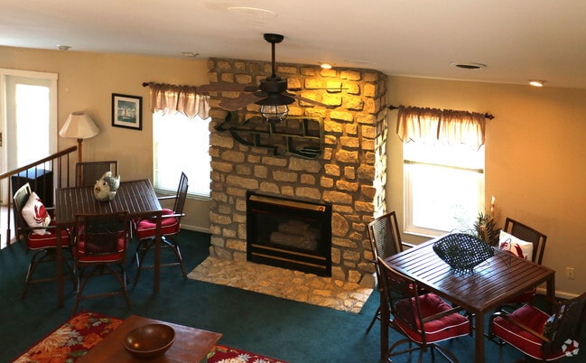
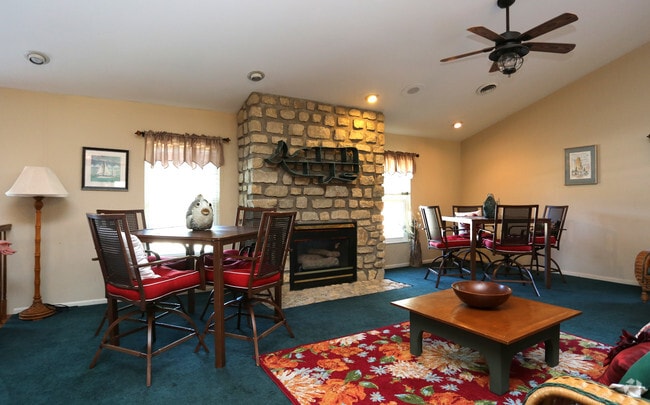
Rentable Clubhouse
-
Rentable Clubhouse
-
Fitness Center
-
Fitness Center
-
Kitchen in Clubhouse
-
Racquetball Room
Lee's Crossing has units with in‑unit washers and dryers, making laundry day simple for residents.
Lee's Crossing includes trash removal in rent. Residents are responsible for any other utilities not listed.
Parking is available at Lee's Crossing. Contact this property for details.
Lee's Crossing has two-bedrooms available with rent ranges from $1,050/mo. to $1,200/mo.
Lee's Crossing does not allow pets, though service animals are always welcome in accordance with applicable laws.
A good rule of thumb is to spend no more than 30% of your gross income on rent. Based on the lowest available rent of $1,050 for a two-bedrooms, you would need to earn about $42,000 per year to qualify. Want to double-check your budget? Calculate how much rent you can afford with our Rent Affordability Calculator.
Lee's Crossing is not currently offering any rent specials. Check back soon, as promotions change frequently.
While Lee's Crossing does not offer Matterport 3D tours, renters can request a tour directly through our online platform.

5326 Lee's Crossing Dr
Cincinnati, OH 45239
Property Manager Responded