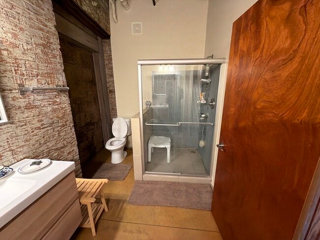
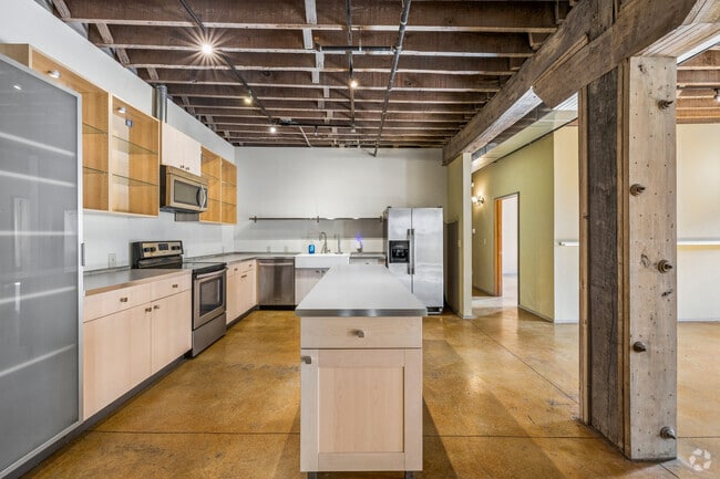
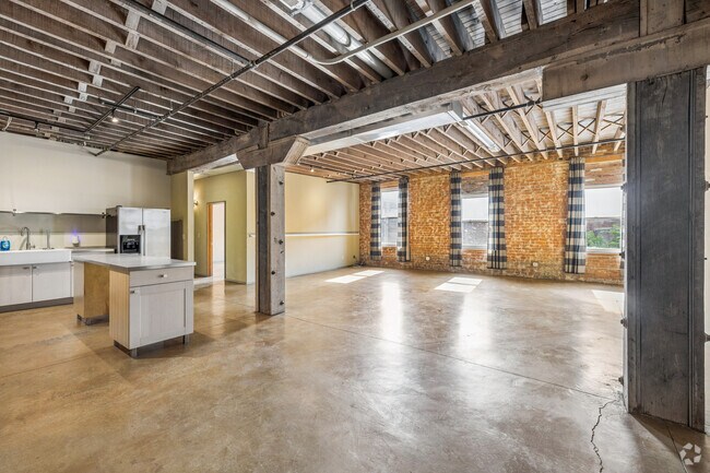
Located at 1220 Harrison Ave in Cincinnati, OH, this striking industrial loft conversion blends raw architectural character with functional living across two floors. The main level commands attention with its vast, open layout, showcasing polished amber-stained concrete floors, exposed wooden beam ceilings, and structural columns that pay homage to the building's industrial heritage. A bold black steel staircase anchors the open living area, leading to the upper level, while a kitchen with stainless steel appliances and butcher block countertops provides a modern counterpoint to the surrounding industrial aesthetic. Throughout the space, original exposed brick walls add warmth and texture, particularly in the bedrooms and common areas, where natural light pours in through large windows dressed with sheer curtains. The primary bedroom offers generous proportions, complete with brick accent walls and soft carpeting. Three full bathrooms serve the residence, including one featuring stone tile surrounding a tub-shower combination. A dedicated laundry room houses a full-size washer and dryer. Four closets and two hallways ensure ample storage and connectivity throughout. The upper mezzanine level provides additional flexible space with panoramic windows offering views of the surrounding Cincinnati skyline.
-

-
Matterport 3D Exterior
-
-
Total Monthly Price
$2,085 - $4,650
-
Bedrooms
1 - 3 bd
-
Bathrooms
2 - 2.5 ba
-
Square Feet
1,716 - 4,500 sq ft

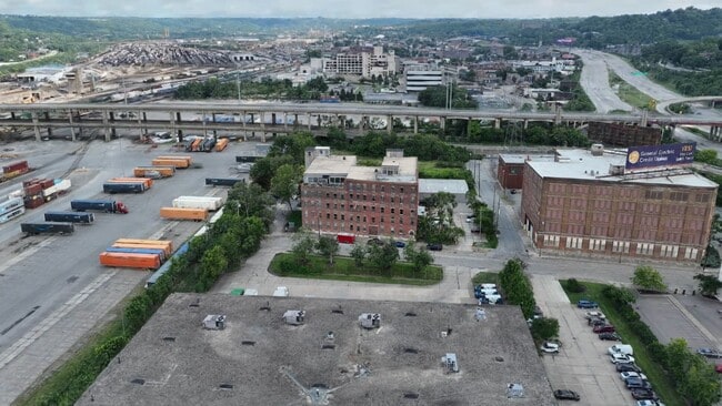
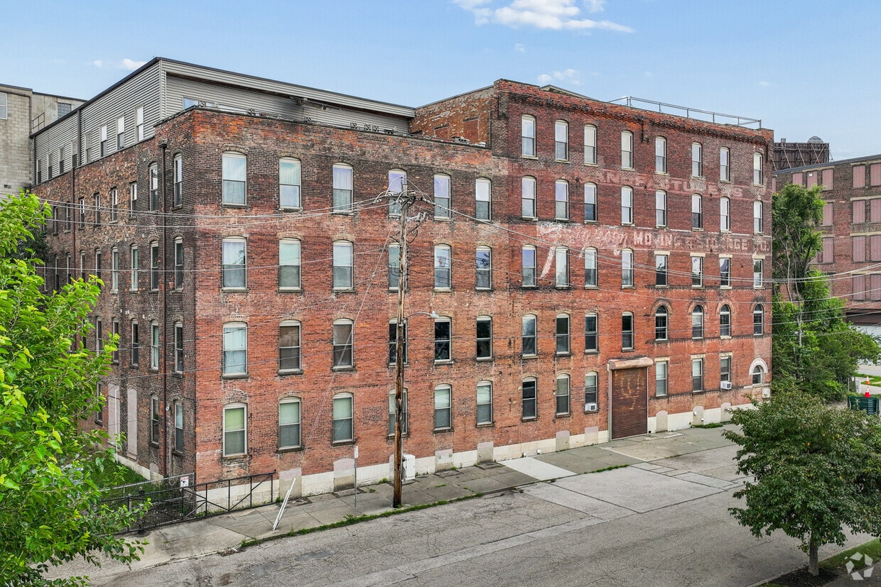
Built in 1864 as a warehouse, the Harrison Terminal Building has been used for furniture manufacturing, bakery supply, trailer sales, rental, advertising, music recording, and several transportation companies. Harrison Terminal sold the building in 1990. Contemporary Urban Soho Loft Living at its FINEST! Located in the North West Region of Cincinnati's Historic Downtown, these renovated warehouses have been modernized with all an environmentally friendly material of which is The Harrison Terminal Lofts Green Building Leed Design Philosophy.
Highlights
- Dock
- Loft Layout
- Yard
- High Ceilings
- Walk-In Closets
- Office
- Controlled Access
- Zen Garden
- Individual Locking Bedrooms
Pricing & Floor Plans
-
Unit 4Cprice $2,085square feet 1,716availibility Aug 1
-
Unit 2Aprice $2,290square feet 1,927availibility Now
-
Unit 2Eprice $2,290square feet 1,760availibility Now
-
Unit 5Cprice $4,590square feet 4,500availibility Now
-
Unit 4Cprice $2,085square feet 1,716availibility Aug 1
-
Unit 2Aprice $2,290square feet 1,927availibility Now
-
Unit 2Eprice $2,290square feet 1,760availibility Now
-
Unit 5Cprice $4,590square feet 4,500availibility Now
Fees and Policies
The fees listed below are community-provided and may exclude utilities or add-ons. All payments are made directly to the property and are non-refundable unless otherwise specified. Use the Cost Calculator to determine costs based on your needs.
-
Utilities & Essentials
-
Valet TrashCharged per unit.$40 / moMax chargeable amount: $40
-
Resident Utility ChargeCharged per resident.$50 - $110 / moMax chargeable amount: $110
-
-
Dogs
-
Pet DepositCharged per unit.$350
-
Pet FeeCharged per pet.$50 / mo
0 lbs. Weight Limit, Pet interview, Spayed/NeuteredRestrictions:Subject to management approvalRead More Read Less -
-
Cats
-
One-Time Pet FeeCharged per pet.$500
-
Monthly Pet FeeCharged per pet.$75 / mo
Pet interview, Spayed/NeuteredRestrictions: -
Property Fee Disclaimer: Based on community-supplied data and independent market research. Subject to change without notice. May exclude fees for mandatory or optional services and usage-based utilities.
Details
Lease Options
-
12 mo
Property Information
-
Built in 2014
-
18 units/5 stories
Matterport 3D Tours
About Harrison Terminal Lofts
Built in 1864 as a warehouse, the Harrison Terminal Building has been used for furniture manufacturing, bakery supply, trailer sales, rental, advertising, music recording, and several transportation companies. Harrison Terminal sold the building in 1990. Contemporary Urban Soho Loft Living at its FINEST! Located in the North West Region of Cincinnati's Historic Downtown, these renovated warehouses have been modernized with all an environmentally friendly material of which is The Harrison Terminal Lofts Green Building Leed Design Philosophy.
Harrison Terminal Lofts is an apartment community located in Hamilton County and the 45214 ZIP Code. This area is served by the Cincinnati Public Schools attendance zone.
Unique Features
- Central Heating & Air
- City Views
- Dual Full Bathrooms
- Elevator Access To All Floors
- Exposed Brick Walls
- Exposed Original Brick
- Extra-large Open Floor Plan
- Fully Renovated
- Ground-floor Restaurant & Gym
- High/loft Ceilings
- Historic 1885 Industrial Building
- In-unit Washer/dryer
- Large / Walk-in Closets
- Large Closets
- On-site Parking & Garage Parking
- Open-concept Floor Plan
- Oversized Industrial Windows
- Pet-friendly
- Polished Concrete Flooring
- Professional Management & Maintenance
Community Amenities
Laundry Facilities
Elevator
Clubhouse
Controlled Access
Recycling
Gated
Community-Wide WiFi
Key Fob Entry
Property Services
- Community-Wide WiFi
- Wi-Fi
- Laundry Facilities
- Controlled Access
- Video Patrol
- 24 Hour Access
- Trash Pickup - Door to Door
- Recycling
- Renters Insurance Program
- Key Fob Entry
Shared Community
- Elevator
- Clubhouse
- Storage Space
- Vintage Building
Outdoor Features
- Gated
- Fenced Lot
- Courtyard
- Picnic Area
- Dock
- Zen Garden
- Dog Park
Student Features
- Individual Locking Bedrooms
- Private Bathroom
- Individual Leases Available
Apartment Features
Washer/Dryer
Air Conditioning
Dishwasher
Washer/Dryer Hookup
Loft Layout
High Speed Internet Access
Hardwood Floors
Walk-In Closets
Indoor Features
- High Speed Internet Access
- Washer/Dryer
- Washer/Dryer Hookup
- Air Conditioning
- Heating
- Ceiling Fans
- Smoke Free
- Cable Ready
- Storage Space
- Double Vanities
- Tub/Shower
- Intercom
- Sprinkler System
Kitchen Features & Appliances
- Dishwasher
- Disposal
- Ice Maker
- Stainless Steel Appliances
- Pantry
- Island Kitchen
- Kitchen
- Microwave
- Oven
- Range
- Refrigerator
- Freezer
Model Details
- Hardwood Floors
- Dining Room
- High Ceilings
- Family Room
- Mud Room
- Office
- Sunroom
- Vaulted Ceiling
- Views
- Walk-In Closets
- Linen Closet
- Loft Layout
- Double Pane Windows
- Window Coverings
- Large Bedrooms
- Patio
- Yard
- Lawn
- Dock
West End is a historic neighborhood about 1.5 miles northwest of Downtown Cincinnati. Once a manufacturing hub for beer, clothing, soap, and other goods, West End is an up-and-coming neighborhood undergoing revitalization. Several new developments are entering the neighborhood including a football stadium set to open in 2021. Along with housing several museums, West End rests next to one of the city’s most popular museums, the Cincinnati Museum Center at Union Terminal.
Combined with its charming historic buildings, West End is known for its strong sense of community. Community gardens and programs at the West End’s several recreation centers are just two ways locals connect. West End has rentals options for every budget in a variety of styles including apartments in renovated brick buildings. Proximity to downtown allows residents to have easy access to Cincinnati’s biggest attractions like the Duke Energy Convention Center and Paul Brown Stadium, home of Cincinnati Bengals.
Learn more about living in West EndCompare neighborhood and city base rent averages by bedroom.
| West End | Cincinnati, OH | |
|---|---|---|
| Studio | $839 | $1,082 |
| 1 Bedroom | $1,335 | $1,146 |
| 2 Bedrooms | $1,108 | $1,434 |
| 3 Bedrooms | $1,396 | $1,745 |
- Community-Wide WiFi
- Wi-Fi
- Laundry Facilities
- Controlled Access
- Video Patrol
- 24 Hour Access
- Trash Pickup - Door to Door
- Recycling
- Renters Insurance Program
- Key Fob Entry
- Elevator
- Clubhouse
- Storage Space
- Vintage Building
- Gated
- Fenced Lot
- Courtyard
- Picnic Area
- Dock
- Zen Garden
- Dog Park
- Individual Locking Bedrooms
- Private Bathroom
- Individual Leases Available
- Central Heating & Air
- City Views
- Dual Full Bathrooms
- Elevator Access To All Floors
- Exposed Brick Walls
- Exposed Original Brick
- Extra-large Open Floor Plan
- Fully Renovated
- Ground-floor Restaurant & Gym
- High/loft Ceilings
- Historic 1885 Industrial Building
- In-unit Washer/dryer
- Large / Walk-in Closets
- Large Closets
- On-site Parking & Garage Parking
- Open-concept Floor Plan
- Oversized Industrial Windows
- Pet-friendly
- Polished Concrete Flooring
- Professional Management & Maintenance
- High Speed Internet Access
- Washer/Dryer
- Washer/Dryer Hookup
- Air Conditioning
- Heating
- Ceiling Fans
- Smoke Free
- Cable Ready
- Storage Space
- Double Vanities
- Tub/Shower
- Intercom
- Sprinkler System
- Dishwasher
- Disposal
- Ice Maker
- Stainless Steel Appliances
- Pantry
- Island Kitchen
- Kitchen
- Microwave
- Oven
- Range
- Refrigerator
- Freezer
- Hardwood Floors
- Dining Room
- High Ceilings
- Family Room
- Mud Room
- Office
- Sunroom
- Vaulted Ceiling
- Views
- Walk-In Closets
- Linen Closet
- Loft Layout
- Double Pane Windows
- Window Coverings
- Large Bedrooms
- Patio
- Yard
- Lawn
- Dock
| Monday | 9am - 5pm |
|---|---|
| Tuesday | 9am - 5pm |
| Wednesday | 9am - 5pm |
| Thursday | 9am - 5pm |
| Friday | 9am - 5pm |
| Saturday | Closed |
| Sunday | Closed |
| Colleges & Universities | Distance | ||
|---|---|---|---|
| Colleges & Universities | Distance | ||
| Drive: | 7 min | 2.5 mi | |
| Drive: | 8 min | 2.8 mi | |
| Drive: | 8 min | 2.9 mi | |
| Drive: | 15 min | 5.0 mi |


View GreatSchools Rating Methodology
Data provided by GreatSchools.org © 2026. All rights reserved.
Transportation options available in Cincinnati include Brewery District Station - Elm & Henry, located 1.1 miles from Harrison Terminal Lofts. Harrison Terminal Lofts is near Cincinnati/Northern Kentucky International, located 15.5 miles or 29 minutes away.
| Transit / Subway | Distance | ||
|---|---|---|---|
| Transit / Subway | Distance | ||
| Walk: | 20 min | 1.1 mi | |
| Drive: | 3 min | 1.3 mi | |
| Drive: | 4 min | 1.4 mi | |
| Drive: | 4 min | 1.5 mi | |
| Drive: | 4 min | 1.6 mi |
| Commuter Rail | Distance | ||
|---|---|---|---|
| Commuter Rail | Distance | ||
|
|
Drive: | 4 min | 1.4 mi |
| Airports | Distance | ||
|---|---|---|---|
| Airports | Distance | ||
|
Cincinnati/Northern Kentucky International
|
Drive: | 29 min | 15.5 mi |
Scores provided by
Traffic
BusyAirport
CalmBusinesses
CalmScores provided by
HowLoud What is a Sound Score Rating? A Sound Score Rating aggregates noise caused by vehicle traffic, airplane traffic and local sources. How It WorksTime and distance from Harrison Terminal Lofts.
| Shopping Centers | Distance | ||
|---|---|---|---|
| Shopping Centers | Distance | ||
| Drive: | 3 min | 1.2 mi | |
| Drive: | 3 min | 1.2 mi | |
| Drive: | 4 min | 1.3 mi |
| Parks and Recreation | Distance | ||
|---|---|---|---|
| Parks and Recreation | Distance | ||
|
Duke Energy Children's Museum
|
Drive: | 4 min | 1.4 mi |
|
Museum of Natural History and Science
|
Drive: | 4 min | 1.4 mi |
|
OMNIMAX Theater
|
Drive: | 4 min | 1.4 mi |
|
Cincinnati History Museum
|
Drive: | 4 min | 1.4 mi |
|
Trailside Nature Center
|
Drive: | 7 min | 2.4 mi |
| Hospitals | Distance | ||
|---|---|---|---|
| Hospitals | Distance | ||
| Drive: | 5 min | 2.2 mi | |
| Drive: | 7 min | 2.2 mi | |
| Drive: | 8 min | 3.0 mi |
| Military Bases | Distance | ||
|---|---|---|---|
| Military Bases | Distance | ||
| Drive: | 69 min | 53.7 mi | |
| Drive: | 75 min | 58.7 mi | |
| Drive: | 78 min | 62.0 mi |
Harrison Terminal Lofts Photos
-
Harrison Terminal Lofts
-
2BR, 2BA - 4,260SF
-
Typical C Master Bathroom
-
2BR, 2BA - 1,760SF - Kitchen
-
2BR, 2BA - 1,760SF - Living Room
-
2BR, 2BA - 1,760SF - Primary Bedroom
-
2BR, 2BA - 1,760SF - Second Bedroom
-
2BR, 2BA - 1,760SF - Second Bathroom
-
2BR, 2BA - 1,760SF - Primary Bathroom
Models
-
2BR, 3BA - 4,260SF
-
2BR, 3BA - 4,260SF
-
2BR, 3BA - 4,260SF
Nearby Apartments
Within 50 Miles of Harrison Terminal Lofts
Harrison Terminal Lofts has units with in‑unit washers and dryers, making laundry day simple for residents.
Utilities are not included in rent. Residents should plan to set up and pay for all services separately.
Parking is available at Harrison Terminal Lofts. Fees may apply depending on the type of parking offered. Contact this property for details.
Harrison Terminal Lofts has one to three-bedrooms with rent ranges from $2,085/mo. to $4,650/mo.
Yes, Harrison Terminal Lofts welcomes pets. Breed restrictions, weight limits, and additional fees may apply. View this property's pet policy.
A good rule of thumb is to spend no more than 30% of your gross income on rent. Based on the lowest available rent of $2,085 for a one-bedroom, you would need to earn about $83,400 per year to qualify. Want to double-check your budget? Calculate how much rent you can afford with our Rent Affordability Calculator.
Harrison Terminal Lofts is not currently offering any rent specials. Check back soon, as promotions change frequently.
Yes! Harrison Terminal Lofts offers 3 Matterport 3D Tours. Explore different floor plans and see unit level details, all without leaving home.
1220 Harrison Ave
Cincinnati, OH 45214