
1213 Walnut
1213 Walnut St,
Philadelphia, PA 19107
$1,945 - $7,060
Studio - 2 Beds


Discover your new apartment at G8one. You'll find this community in the North Philadelphia East area of Philadelphia. Leasing studio to 2 bedroom apartments, your new place is ready for you. Let the knowledgeable leasing staff show you everything this community has in store. So get a head start on your move. Contact or stop by G8one to see available floor plans!
G8one is an apartment community located in Philadelphia County and the 19122 ZIP Code. This area is served by the The School District of Philadelphia attendance zone.
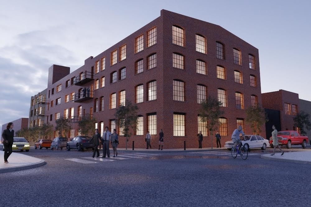
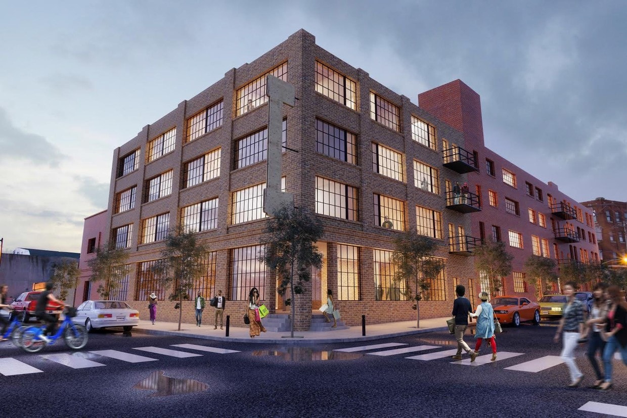
Located just west of Fishtown, Olde Kensington is an industrial neighborhood turned creative haven. Residents cherish Olde Kensington’s blend of modern and historic buildings, with many containing a variety of apartments and lofts available for rent.
The neighborhood exudes an artistic vibe, boasting a slew of art galleries, performing arts venues, design centers, and vibrant murals. Many of the rentals in Olde Kensington are within walking distance of eclectic eateries, dive bars, and independent businesses.
The community enjoys convenience to the exciting offerings of North Front Street as well as Northern Liberties’ North 2nd Street. Center City is also about two miles away. Getting around from Olde Kensington is easy with access to SEPTA trains and buses.
Learn more about living in Olde KensingtonCompare neighborhood and city base rent averages by bedroom.
| Olde Kensington | Philadelphia, PA | |
|---|---|---|
| Studio | $1,353 | $1,433 |
| 1 Bedroom | $1,798 | $1,786 |
| 2 Bedrooms | $2,458 | $2,227 |
| 3 Bedrooms | $3,079 | $2,919 |
| Colleges & Universities | Distance | ||
|---|---|---|---|
| Colleges & Universities | Distance | ||
| Drive: | 3 min | 1.2 mi | |
| Drive: | 5 min | 2.2 mi | |
| Drive: | 7 min | 2.2 mi | |
| Drive: | 6 min | 2.3 mi |


Transportation options available in Philadelphia include Girard Av & 3Rd St, located 0.2 mile from G8one. G8one is near Philadelphia International, located 13.0 miles or 23 minutes away, and Trenton Mercer, located 32.2 miles or 48 minutes away.
| Transit / Subway | Distance | ||
|---|---|---|---|
| Transit / Subway | Distance | ||
| Walk: | 4 min | 0.2 mi | |
| Walk: | 4 min | 0.3 mi | |
| Walk: | 5 min | 0.3 mi | |
| Walk: | 6 min | 0.4 mi | |
| Walk: | 8 min | 0.4 mi |
| Commuter Rail | Distance | ||
|---|---|---|---|
| Commuter Rail | Distance | ||
|
|
Walk: | 18 min | 0.9 mi |
|
|
Drive: | 5 min | 1.9 mi |
|
|
Drive: | 5 min | 2.1 mi |
|
|
Drive: | 5 min | 2.3 mi |
|
|
Drive: | 7 min | 2.7 mi |
| Airports | Distance | ||
|---|---|---|---|
| Airports | Distance | ||
|
Philadelphia International
|
Drive: | 23 min | 13.0 mi |
|
Trenton Mercer
|
Drive: | 48 min | 32.2 mi |
Scores provided by
Traffic
ActiveAirport
CalmBusinesses
BusyScores provided by
HowLoud What is a Sound Score Rating? A Sound Score Rating aggregates noise caused by vehicle traffic, airplane traffic and local sources. How It WorksTime and distance from G8one.
| Shopping Centers | Distance | ||
|---|---|---|---|
| Shopping Centers | Distance | ||
| Walk: | 8 min | 0.4 mi | |
| Walk: | 12 min | 0.7 mi | |
| Drive: | 4 min | 1.3 mi |
| Parks and Recreation | Distance | ||
|---|---|---|---|
| Parks and Recreation | Distance | ||
|
Edgar Allan Poe Nat'l Historic Site
|
Drive: | 3 min | 1.3 mi |
|
Wagner Free Institute of Science
|
Drive: | 4 min | 1.6 mi |
|
Independence National Historical Park
|
Drive: | 4 min | 1.8 mi |
|
Great Egg Harbor River
|
Drive: | 5 min | 1.9 mi |
|
Lower Delaware National Wild and Scenic River
|
Drive: | 5 min | 1.9 mi |
| Hospitals | Distance | ||
|---|---|---|---|
| Hospitals | Distance | ||
| Drive: | 5 min | 2.1 mi | |
| Drive: | 5 min | 2.3 mi | |
| Drive: | 6 min | 2.5 mi |
| Military Bases | Distance | ||
|---|---|---|---|
| Military Bases | Distance | ||
| Drive: | 14 min | 7.3 mi | |
| Drive: | 39 min | 18.5 mi | |
| Drive: | 39 min | 20.5 mi |
What Are Walk Score®, Transit Score®, and Bike Score® Ratings?
Walk Score® measures the walkability of any address. Transit Score® measures access to public transit. Bike Score® measures the bikeability of any address.
What is a Sound Score Rating?
A Sound Score Rating aggregates noise caused by vehicle traffic, airplane traffic and local sources.
1401 Germantown Ave
Philadelphia, PA 19122


