
Venue Residences
3688 Overland Ave,
Los Angeles, CA 90034
$3,150 - $4,795
Studio - 2 Beds
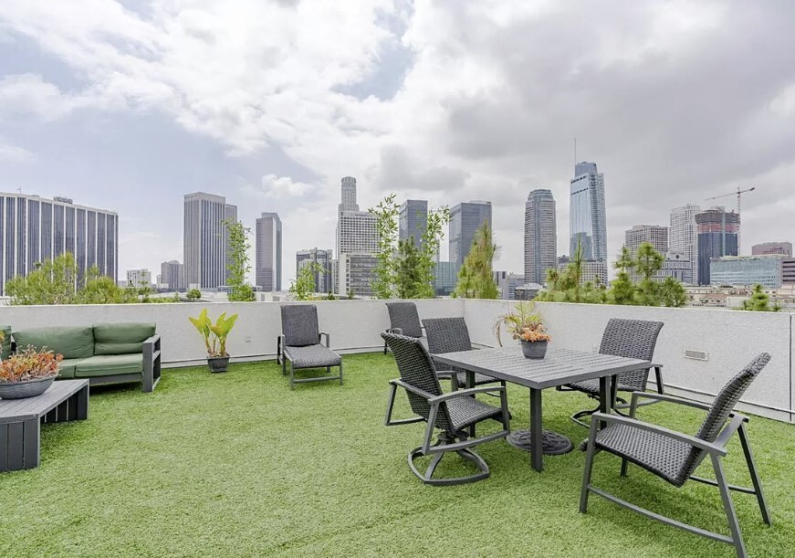

The 4th Street Lofts is a ten-unit apartment building constructed in 2005 in a location just west of downtown Los Angeles. The property features four levels of apartments over a level of on-grade parking. The property features incredible 360-degree views of the Downtown LA skyline and Hollywood. The units offer wood kitchen cabinets and upgraded stainless-steel appliances, and a washer / dryer in each unit.
Fourth Street Lofts is an apartment community located in Los Angeles County and the 90017 ZIP Code. This area is served by the Los Angeles Unified Rocp School District attendance zone.
Elevator
Roof Terrace
Grill
24 Hour Access
Washer/Dryer
Walk-In Closets
Stainless Steel Appliances
Security System
Nestled along State Route 11, City West is just what you’d expect it to be — it’s directly west of Downtown Los Angeles. Home to hospitals, public schools, and neighborhood parks, City West is the perfect suburb for renters wanting to stay close to the heart of Los Angeles. Apartments, houses, condos, and townhomes are available for rent in the area, ranging from affordable to upscale. This family-friendly sector of the city provides residents with a break from big-city living while still offering a quick commute for work or leisure. Enjoy scenic views of the city skyline from Vista Hermosa Natural Park or enjoy a free summer concert nearby at Levitt Pavilion.
Learn more about living in City WestCompare neighborhood and city base rent averages by bedroom.
| City West | Los Angeles, CA | |
|---|---|---|
| Studio | $1,550 | $1,710 |
| 1 Bedroom | $2,295 | $2,184 |
| 2 Bedrooms | $3,102 | $3,022 |
| 3 Bedrooms | $4,416 | $4,280 |
| Colleges & Universities | Distance | ||
|---|---|---|---|
| Colleges & Universities | Distance | ||
| Walk: | 15 min | 0.8 mi | |
| Walk: | 17 min | 0.9 mi | |
| Drive: | 3 min | 1.4 mi | |
| Drive: | 5 min | 2.0 mi |


Transportation options available in Los Angeles include Grand Ave Arts / Bunker Hill Station, located 0.7 mile from Fourth Street Lofts. Fourth Street Lofts is near Los Angeles International, located 14.7 miles or 25 minutes away, and Bob Hope, located 15.6 miles or 23 minutes away.
| Transit / Subway | Distance | ||
|---|---|---|---|
| Transit / Subway | Distance | ||
| Walk: | 13 min | 0.7 mi | |
|
|
Walk: | 15 min | 0.8 mi |
|
|
Walk: | 21 min | 1.1 mi |
|
|
Drive: | 3 min | 1.1 mi |
|
|
Drive: | 3 min | 1.3 mi |
| Commuter Rail | Distance | ||
|---|---|---|---|
| Commuter Rail | Distance | ||
|
|
Drive: | 5 min | 2.2 mi |
|
|
Drive: | 7 min | 2.3 mi |
|
|
Drive: | 9 min | 5.5 mi |
| Drive: | 9 min | 6.1 mi | |
|
|
Drive: | 17 min | 10.8 mi |
| Airports | Distance | ||
|---|---|---|---|
| Airports | Distance | ||
|
Los Angeles International
|
Drive: | 25 min | 14.7 mi |
|
Bob Hope
|
Drive: | 23 min | 15.6 mi |
Scores provided by
Traffic
-Airport
-Businesses
-Scores provided by
HowLoud What is a Sound Score Rating? A Sound Score Rating aggregates noise caused by vehicle traffic, airplane traffic and local sources. How It WorksTime and distance from Fourth Street Lofts.
| Shopping Centers | Distance | ||
|---|---|---|---|
| Shopping Centers | Distance | ||
| Walk: | 12 min | 0.7 mi | |
| Walk: | 14 min | 0.7 mi | |
| Walk: | 15 min | 0.8 mi |
| Parks and Recreation | Distance | ||
|---|---|---|---|
| Parks and Recreation | Distance | ||
|
Vista Hermosa Natural Park
|
Walk: | 10 min | 0.5 mi |
|
MacArthur Park Lake
|
Drive: | 3 min | 1.2 mi |
|
Echo Park Lake
|
Drive: | 3 min | 1.3 mi |
|
Chavez Ravine Arboretum
|
Drive: | 6 min | 2.9 mi |
|
Elysian Park
|
Drive: | 10 min | 4.3 mi |
| Hospitals | Distance | ||
|---|---|---|---|
| Hospitals | Distance | ||
| Walk: | 7 min | 0.4 mi | |
| Walk: | 17 min | 0.9 mi | |
| Walk: | 18 min | 1.0 mi |
| Military Bases | Distance | ||
|---|---|---|---|
| Military Bases | Distance | ||
| Drive: | 22 min | 16.2 mi |
What Are Walk Score®, Transit Score®, and Bike Score® Ratings?
Walk Score® measures the walkability of any address. Transit Score® measures access to public transit. Bike Score® measures the bikeability of any address.
What is a Sound Score Rating?
A Sound Score Rating aggregates noise caused by vehicle traffic, airplane traffic and local sources.

1340 W 4th St
Los Angeles, CA 90017


