-
Monthly Rent
$5,895 - $9,990
-
Bedrooms
2 - 3 bd
-
Bathrooms
2 - 3 ba
-
Square Feet
785 - 1,000 sq ft

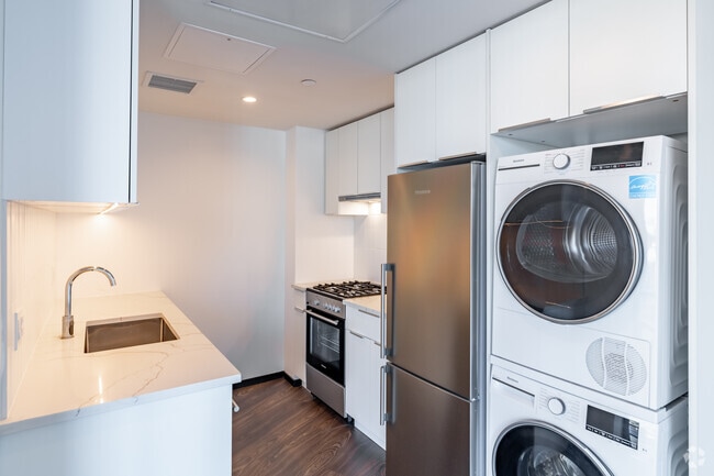
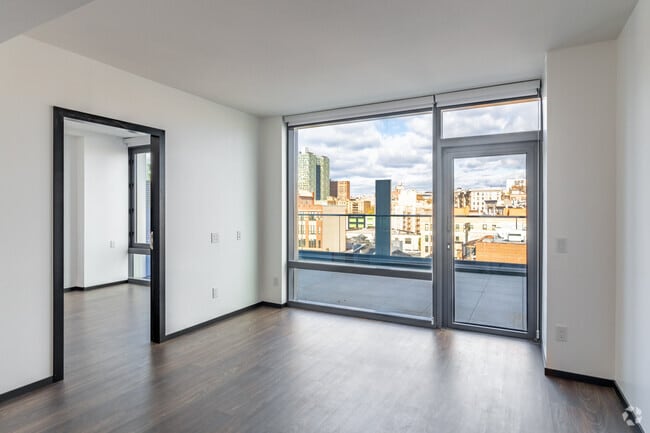
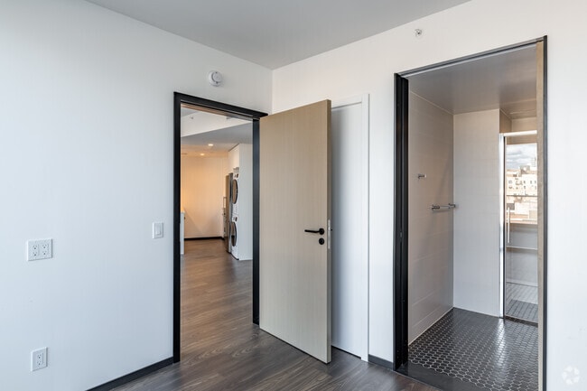
Prepare to be captivated! Stepping into these gorgeous brand new apartments immediately takes your breath away. Floor-to-ceiling windows flood the already spacious interior with natural light, creating a bright, warm, and inviting atmosphere. The fully equipped gourmet kitchen boasts all brand-new, top-tier appliances, including a four-burner gas stove and oven, dishwasher, and a large fridge/freezer unit. The units are equipped for modern living, featuring smart key-fob entry, an in-unit washer & dryer, and individually controlled heating and cooling, ensuring comfort, security, and efficiency in every detail. With multiple floorplans available in 2 Bedroom 2 Bathroom options, you're sure to find the one that's right for you! The Forten Building sets itself apart with premium amenities: 24/7 Doorman Rooftop Deck with a full BBQ setup and panoramic views Fully equipped state-of-the-art Gym Communal Lounge Area Common Courtyard With its amazing proximity to transit and everything New York City has to offer, this is a truly unbeatable location. Experience high-rise living at its finest—come see it and move in!
Highlights
- New Construction
- Walker's Paradise
- Premier Transit Location
- Floor to Ceiling Windows
- Walk To Campus
- Roof Terrace
- Pool
- Deck
- Controlled Access
Pricing & Floor Plans
-
Unit 1205price $5,895square feet 834availibility Now
-
Unit 1111price $6,300square feet 785availibility Now
-
Unit 1611price $6,500square feet 785availibility Now
-
Unit 1205price $5,895square feet 834availibility Now
-
Unit 1111price $6,300square feet 785availibility Now
-
Unit 1611price $6,500square feet 785availibility Now
Fees and Policies
The fees below are based on community-supplied data and may exclude additional fees and utilities.
Pet policies are negotiable.
-
Valet
-
Parking FeeCharged per vehicle. Payable to 3rd Party$700 / mo
CommentsParking is run and managed by a third party company. Their fees and charges may vary slightly to the advertised price on this advert.Read More Read Less -
-
Additional Parking Options
-
Garage Lot
-
Property Fee Disclaimer: Based on community-supplied data and independent market research. Subject to change without notice. May exclude fees for mandatory or optional services and usage-based utilities.
Details
Utilities Included
-
Gas
-
Water
Lease Options
-
Short term lease
Property Information
-
Built in 2025
-
92 units/18 stories
-
Furnished Units Available
Matterport 3D Tours
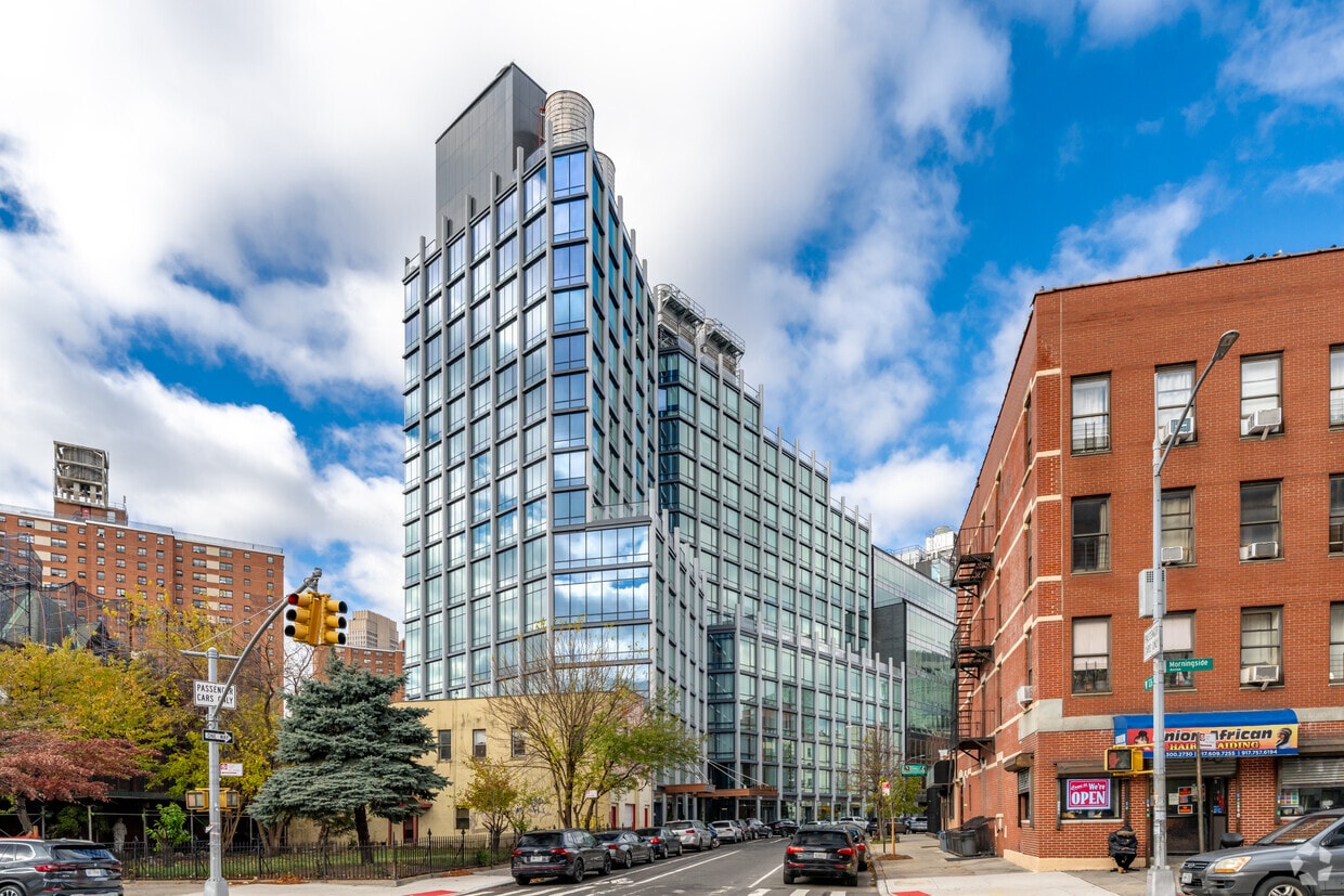
About Forten at Columbia
Prepare to be captivated! Stepping into these gorgeous brand new apartments immediately takes your breath away. Floor-to-ceiling windows flood the already spacious interior with natural light, creating a bright, warm, and inviting atmosphere. The fully equipped gourmet kitchen boasts all brand-new, top-tier appliances, including a four-burner gas stove and oven, dishwasher, and a large fridge/freezer unit. The units are equipped for modern living, featuring smart key-fob entry, an in-unit washer & dryer, and individually controlled heating and cooling, ensuring comfort, security, and efficiency in every detail. With multiple floorplans available in 2 Bedroom 2 Bathroom options, you're sure to find the one that's right for you! The Forten Building sets itself apart with premium amenities: 24/7 Doorman Rooftop Deck with a full BBQ setup and panoramic views Fully equipped state-of-the-art Gym Communal Lounge Area Common Courtyard With its amazing proximity to transit and everything New York City has to offer, this is a truly unbeatable location. Experience high-rise living at its finest—come see it and move in!
Forten at Columbia is an apartment community located in New York County and the 10027 ZIP Code. This area is served by the New York City Geographic District # 5 attendance zone.
Community Amenities
Pool
Fitness Center
Elevator
Doorman
- Controlled Access
- Doorman
- Concierge
- 24 Hour Access
- Elevator
- Business Center
- Clubhouse
- Lounge
- Fitness Center
- Pool
- Bicycle Storage
- Roof Terrace
- Courtyard
- Grill
- Shuttle To Campus
- Study Lounge
- Walk To Campus
Apartment Features
Washer/Dryer
Air Conditioning
Dishwasher
Hardwood Floors
Refrigerator
Tub/Shower
Freezer
Patio
Indoor Features
- Washer/Dryer
- Air Conditioning
- Heating
- Cable Ready
- Trash Compactor
- Tub/Shower
- Intercom
Kitchen Features & Appliances
- Dishwasher
- Stainless Steel Appliances
- Kitchen
- Oven
- Refrigerator
- Freezer
- Quartz Countertops
Model Details
- Hardwood Floors
- Views
- Furnished
- Floor to Ceiling Windows
- Balcony
- Patio
- Deck
- Controlled Access
- Doorman
- Concierge
- 24 Hour Access
- Elevator
- Business Center
- Clubhouse
- Lounge
- Roof Terrace
- Courtyard
- Grill
- Fitness Center
- Pool
- Bicycle Storage
- Shuttle To Campus
- Study Lounge
- Walk To Campus
- Washer/Dryer
- Air Conditioning
- Heating
- Cable Ready
- Trash Compactor
- Tub/Shower
- Intercom
- Dishwasher
- Stainless Steel Appliances
- Kitchen
- Oven
- Refrigerator
- Freezer
- Quartz Countertops
- Hardwood Floors
- Views
- Furnished
- Floor to Ceiling Windows
- Balcony
- Patio
- Deck
| Monday | By Appointment |
|---|---|
| Tuesday | By Appointment |
| Wednesday | By Appointment |
| Thursday | By Appointment |
| Friday | By Appointment |
| Saturday | By Appointment |
| Sunday | By Appointment |
Manhattanville, sometimes referred to as West Harlem, is a vibrant neighborhood combining the urban vibe of Harlem with the intellectual presence of nearby Columbia University and the City College of New York. A host of university students, faculty, and staff call Manhattanville home, shaping much of the area’s rental opportunities.
Manhattanville’s cultural legacy is rich, touting numerous jazz clubs throughout the neighborhood along with quick access to the famous Apollo Theater. Although the neighborhood sits far north in Manhattan, a wealth of public transportation options make it easy to connect to the rest of NYC.
Learn more about living in ManhattanvilleCompare neighborhood and city base rent averages by bedroom.
| Manhattanville | New York, NY | |
|---|---|---|
| Studio | $2,310 | $3,274 |
| 1 Bedroom | $2,734 | $4,033 |
| 2 Bedrooms | $3,230 | $5,506 |
| 3 Bedrooms | $4,390 | $7,027 |
| Colleges & Universities | Distance | ||
|---|---|---|---|
| Colleges & Universities | Distance | ||
| Walk: | 10 min | 0.6 mi | |
| Walk: | 11 min | 0.6 mi | |
| Walk: | 15 min | 0.8 mi | |
| Walk: | 15 min | 0.8 mi |


View GreatSchools Rating Methodology
Data provided by GreatSchools.org © 2026. All rights reserved.
Transportation options available in New York include 125 Street (A,B,C,D Line), located 0.1 mile from Forten at Columbia. Forten at Columbia is near LaGuardia, located 7.2 miles or 16 minutes away, and Newark Liberty International, located 23.1 miles or 29 minutes away.
| Transit / Subway | Distance | ||
|---|---|---|---|
| Transit / Subway | Distance | ||
|
|
Walk: | 2 min | 0.1 mi |
|
|
Walk: | 7 min | 0.4 mi |
|
|
Walk: | 11 min | 0.6 mi |
|
|
Walk: | 11 min | 0.6 mi |
|
|
Walk: | 12 min | 0.6 mi |
| Commuter Rail | Distance | ||
|---|---|---|---|
| Commuter Rail | Distance | ||
|
|
Drive: | 3 min | 1.4 mi |
|
|
Drive: | 7 min | 2.9 mi |
|
|
Drive: | 11 min | 3.6 mi |
| Drive: | 9 min | 4.8 mi | |
|
|
Drive: | 12 min | 5.6 mi |
| Airports | Distance | ||
|---|---|---|---|
| Airports | Distance | ||
|
LaGuardia
|
Drive: | 16 min | 7.2 mi |
|
Newark Liberty International
|
Drive: | 29 min | 23.1 mi |
Time and distance from Forten at Columbia.
| Shopping Centers | Distance | ||
|---|---|---|---|
| Shopping Centers | Distance | ||
| Walk: | 5 min | 0.3 mi | |
| Drive: | 7 min | 2.4 mi | |
| Drive: | 14 min | 7.5 mi |
| Parks and Recreation | Distance | ||
|---|---|---|---|
| Parks and Recreation | Distance | ||
|
St. Nicholas Park
|
Walk: | 10 min | 0.5 mi |
|
Morningside Park
|
Walk: | 11 min | 0.6 mi |
|
Marcus Garvey Park
|
Drive: | 3 min | 1.2 mi |
|
Riverside Park
|
Drive: | 6 min | 2.7 mi |
|
Riverbank State Park
|
Drive: | 6 min | 2.7 mi |
| Hospitals | Distance | ||
|---|---|---|---|
| Hospitals | Distance | ||
| Drive: | 4 min | 1.4 mi | |
| Drive: | 7 min | 2.4 mi | |
| Drive: | 5 min | 2.5 mi |
| Military Bases | Distance | ||
|---|---|---|---|
| Military Bases | Distance | ||
| Drive: | 24 min | 10.2 mi | |
| Drive: | 25 min | 13.2 mi |
Forten at Columbia Photos
-
Forten at Columbia
-
2BR, 2BA - 748SF Tour
-
2BR, 2BA - 748SF - Kitchen
-
2BR, 2BA - 748SF - Living Room
-
2BR, 2BA - 748SF - Bedroom
-
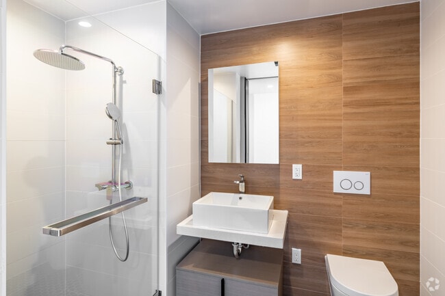
2BR, 2BA - 748SF - Bathroom
-
2BR, 2BA - 748SF - Balcony
-
2BR, 2BA - 760SF - Kitchen
-
2BR, 2BA - 760SF - Living Room
Forten at Columbia has units with in‑unit washers and dryers, making laundry day simple for residents.
Select utilities are included in rent at Forten at Columbia, including gas and water. Residents are responsible for any other utilities not listed.
Parking is available at Forten at Columbia. Fees may apply depending on the type of parking offered. Contact this property for details.
Forten at Columbia has two to three-bedrooms with rent ranges from $5,895/mo. to $9,990/mo.
Forten at Columbia does not allow pets, though service animals are always welcome in accordance with applicable laws.
A good rule of thumb is to spend no more than 30% of your gross income on rent. Based on the lowest available rent of $5,895 for a two-bedrooms, you would need to earn about $212,000 per year to qualify. Want to double-check your budget? Try our Rent Affordability Calculator to see how much rent fits your income and lifestyle.
Forten at Columbia is not currently offering any rent specials. Check back soon, as promotions change frequently.
Yes! Forten at Columbia offers 2 Matterport 3D Tours. Explore different floor plans and see unit level details, all without leaving home.
What Are Walk Score®, Transit Score®, and Bike Score® Ratings?
Walk Score® measures the walkability of any address. Transit Score® measures access to public transit. Bike Score® measures the bikeability of any address.
What is a Sound Score Rating?
A Sound Score Rating aggregates noise caused by vehicle traffic, airplane traffic and local sources

410 W 126th St
New York, NY 10027