
Citrus Commons
14150 Riverside Dr,
Sherman Oaks, CA 91423
$2,795 - $5,995
Studio - 2 Beds


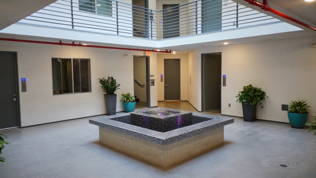
Conveniently Located Near Ventura Blvd, Restaurants, Shopping, Easy Freeway Access, Excellent Schools, Fashion Square Mall, Sherman Oaks Galleria, Universal City Walk, Cafe's, And MORE!! Stylish Industrial Vibe. Architectural Design. Full Size Stacked Washer & Dryer In Unit For Your Convenience. Energy Efficient LED Recessed Lighting. Dual Pane Windows Throughout & High Ceilings. Generous Sized Balconies With Amazing Views. Secured Subterranean Parking Garage With Electric Car Charger Station. FREE Wi-Fi. Fitness Center With State of the Art Equipment, TVs, and Refreshment Bar. Controlled Access With Security Cameras Throughout. Sizable Elevator. Sun Deck With Patio Furniture & BBQ Perfect For You And Your Guests To Enjoy! ENZO Is "GREEN" Solar Powered.
Enzo is an apartment community located in Los Angeles County and the 91423 ZIP Code. This area is served by the Los Angeles Unified Rocp School District attendance zone.
Unique Features
Fitness Center
Elevator
Roof Terrace
Controlled Access
Recycling
Grill
Gated
Community-Wide WiFi
Washer/Dryer
Air Conditioning
Dishwasher
High Speed Internet Access
Hardwood Floors
Walk-In Closets
Granite Countertops
Microwave
Located in the heart of the San Fernando Valley, Sherman Oaks combines residential comfort with city accessibility. This established neighborhood, spanning 14 square miles and extending into the Santa Monica Mountains, features tree-lined streets and varied housing options. Current rental trends show one-bedroom apartments averaging $2,069 and two-bedroom units around $2,696.
Life in Sherman Oaks centers around Ventura Boulevard, home to local shops, restaurants, and entertainment venues. The community offers several recreational spaces, including Van Nuys Sherman Oaks Park with its tennis courts, swimming pools, and expansive grounds. Westfield Fashion Square provides shopping options, while Sherman Oaks Castle Park features miniature golf courses and an arcade. Established in 1927 by General Moses Hazeltine Sherman, the area has evolved from agricultural land into an established Los Angeles neighborhood.
Learn more about living in Sherman Oaks| Colleges & Universities | Distance | ||
|---|---|---|---|
| Colleges & Universities | Distance | ||
| Drive: | 7 min | 2.8 mi | |
| Drive: | 9 min | 5.9 mi | |
| Drive: | 17 min | 10.8 mi | |
| Drive: | 23 min | 11.9 mi |


Transportation options available in Sherman Oaks include Universal City/Studio City, located 3.9 miles from Enzo. Enzo is near Bob Hope, located 7.3 miles or 14 minutes away, and Los Angeles International, located 20.2 miles or 29 minutes away.
| Transit / Subway | Distance | ||
|---|---|---|---|
| Transit / Subway | Distance | ||
|
|
Drive: | 6 min | 3.9 mi |
|
|
Drive: | 8 min | 4.9 mi |
|
|
Drive: | 12 min | 7.0 mi |
|
|
Drive: | 12 min | 7.3 mi |
|
|
Drive: | 13 min | 8.0 mi |
| Commuter Rail | Distance | ||
|---|---|---|---|
| Commuter Rail | Distance | ||
|
|
Drive: | 11 min | 6.1 mi |
|
|
Drive: | 14 min | 7.7 mi |
|
|
Drive: | 13 min | 7.9 mi |
|
|
Drive: | 14 min | 8.2 mi |
| Drive: | 15 min | 8.5 mi |
| Airports | Distance | ||
|---|---|---|---|
| Airports | Distance | ||
|
Bob Hope
|
Drive: | 14 min | 7.3 mi |
|
Los Angeles International
|
Drive: | 29 min | 20.2 mi |
Time and distance from Enzo.
| Shopping Centers | Distance | ||
|---|---|---|---|
| Shopping Centers | Distance | ||
| Walk: | 4 min | 0.3 mi | |
| Walk: | 8 min | 0.5 mi | |
| Walk: | 11 min | 0.6 mi |
| Parks and Recreation | Distance | ||
|---|---|---|---|
| Parks and Recreation | Distance | ||
|
Franklin Canyon Park
|
Drive: | 11 min | 3.5 mi |
|
Sooky Goldman Nature Center
|
Drive: | 11 min | 3.6 mi |
|
The Japanese Garden
|
Drive: | 8 min | 5.3 mi |
|
Sepulveda Basin Wildlife Reserve
|
Drive: | 12 min | 5.7 mi |
|
Skirball Cultural Center
|
Drive: | 10 min | 6.2 mi |
| Hospitals | Distance | ||
|---|---|---|---|
| Hospitals | Distance | ||
| Drive: | 4 min | 2.2 mi | |
| Drive: | 6 min | 3.8 mi | |
| Drive: | 9 min | 5.7 mi |
| Military Bases | Distance | ||
|---|---|---|---|
| Military Bases | Distance | ||
| Drive: | 29 min | 22.8 mi |
Pets Allowed In Unit Washer & Dryer Maintenance on site Heat Controlled Access Elevator
What Are Walk Score®, Transit Score®, and Bike Score® Ratings?
Walk Score® measures the walkability of any address. Transit Score® measures access to public transit. Bike Score® measures the bikeability of any address.
What is a Sound Score Rating?
A Sound Score Rating aggregates noise caused by vehicle traffic, airplane traffic and local sources.
13309 Woodbridge St
Sherman Oaks, CA 91423


