
The Darien
815 Poplar St,
Philadelphia, PA 19123
Studio - 3 Beds $1,600 - $4,255
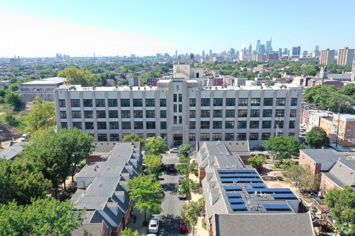
Visit Edison 64 in Philadelphia, PA. The 700 W. Somerset St. location in the Fairhill neighborhood of Philadelphia is convenient to everything. From amenities to availability, the professional leasing staff will assist you in finding your dream apartment. Select from 1 to 2 bedroom apartments and then schedule a tour. Come see Edison 64 today.
Edison 64 is an apartment community located in Philadelphia County and the 19133 ZIP Code. This area is served by the The School District of Philadelphia attendance zone.
Located north of West Kensington and south of North Philadelphia, Fairhill is a terrific neighborhood just four miles north of Downtown Philadelphia. This neighborhood consists of classic Philadelphia row homes and apartments. It is bordered by Glenwood Avenue to the north and Lehigh Avenue to the south. Fairhill blends historic and urban, featuring narrow streets, wide sidewalks, and colonial architecture. Fairhill is named for the Fair Hill plantation built by Isaac Norris in the early 1700s. The Fair Hill Burial Ground is a Fairhill landmark. This cemetery, listed on the National Register of Historic Places, was founded by Quakers in 1703.
If you need to stock up on anything from groceries and baked goods to car parts, you won't have to travel far. In fact, locals love Fairhill's convenience to a Save-A-Lot, Family Dollar, and Tru-Value Hardware. When you prefer to have dinner out, head to Freddy & Tony's Restaurant or El Principe.
Learn more about living in Fairhill| Colleges & Universities | Distance | ||
|---|---|---|---|
| Colleges & Universities | Distance | ||
| Walk: | 19 min | 1.0 mi | |
| Drive: | 5 min | 1.8 mi | |
| Drive: | 8 min | 3.3 mi | |
| Drive: | 9 min | 3.3 mi |

Transportation options available in Philadelphia include Allegheny (Bss), located 0.9 mile from Edison 64. Edison 64 is near Philadelphia International, located 15.8 miles or 27 minutes away, and Trenton Mercer, located 32.6 miles or 49 minutes away.
| Transit / Subway | Distance | ||
|---|---|---|---|
| Transit / Subway | Distance | ||
|
|
Walk: | 17 min | 0.9 mi |
|
|
Drive: | 3 min | 1.1 mi |
|
|
Drive: | 3 min | 1.3 mi |
|
|
Drive: | 3 min | 1.4 mi |
|
|
Drive: | 3 min | 1.4 mi |
| Commuter Rail | Distance | ||
|---|---|---|---|
| Commuter Rail | Distance | ||
|
|
Walk: | 10 min | 0.5 mi |
|
|
Walk: | 14 min | 0.8 mi |
|
|
Drive: | 3 min | 1.2 mi |
|
|
Walk: | 22 min | 1.2 mi |
|
|
Drive: | 4 min | 1.6 mi |
| Airports | Distance | ||
|---|---|---|---|
| Airports | Distance | ||
|
Philadelphia International
|
Drive: | 27 min | 15.8 mi |
|
Trenton Mercer
|
Drive: | 49 min | 32.6 mi |
Time and distance from Edison 64.
| Shopping Centers | Distance | ||
|---|---|---|---|
| Shopping Centers | Distance | ||
| Walk: | 2 min | 0.1 mi | |
| Walk: | 16 min | 0.9 mi | |
| Walk: | 17 min | 0.9 mi |
| Parks and Recreation | Distance | ||
|---|---|---|---|
| Parks and Recreation | Distance | ||
|
Wagner Free Institute of Science
|
Drive: | 6 min | 1.9 mi |
|
Edgar Allan Poe Nat'l Historic Site
|
Drive: | 7 min | 2.6 mi |
|
The Academy of Natural Sciences
|
Drive: | 9 min | 3.8 mi |
|
Tacony Creek Park
|
Drive: | 10 min | 4.0 mi |
|
Fels Planetarium
|
Drive: | 10 min | 4.0 mi |
| Hospitals | Distance | ||
|---|---|---|---|
| Hospitals | Distance | ||
| Walk: | 19 min | 1.0 mi | |
| Drive: | 3 min | 1.3 mi | |
| Drive: | 4 min | 1.7 mi |
| Military Bases | Distance | ||
|---|---|---|---|
| Military Bases | Distance | ||
| Drive: | 18 min | 10.2 mi |
What Are Walk Score®, Transit Score®, and Bike Score® Ratings?
Walk Score® measures the walkability of any address. Transit Score® measures access to public transit. Bike Score® measures the bikeability of any address.
What is a Sound Score Rating?
A Sound Score Rating aggregates noise caused by vehicle traffic, airplane traffic and local sources

700 W Somerset St
Philadelphia, PA 19133


