
Living at Santa Monica
1519 6th St,
Santa Monica, CA 90401
Studio - 2 Beds $2,542 - $4,938

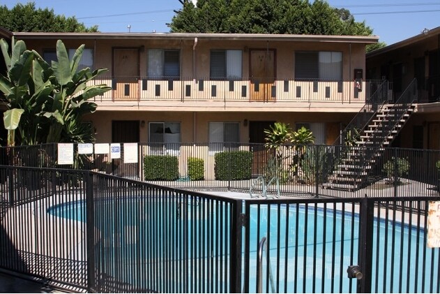
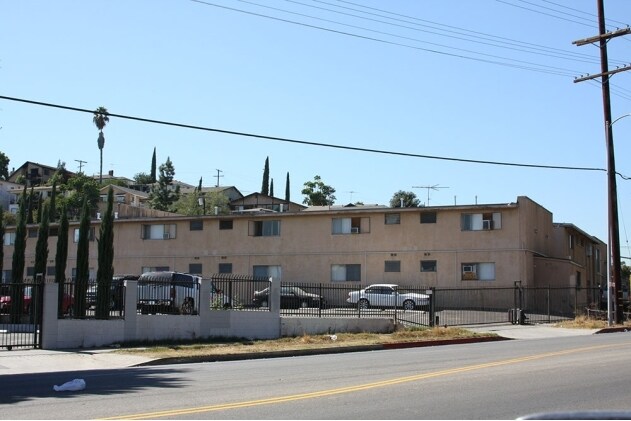

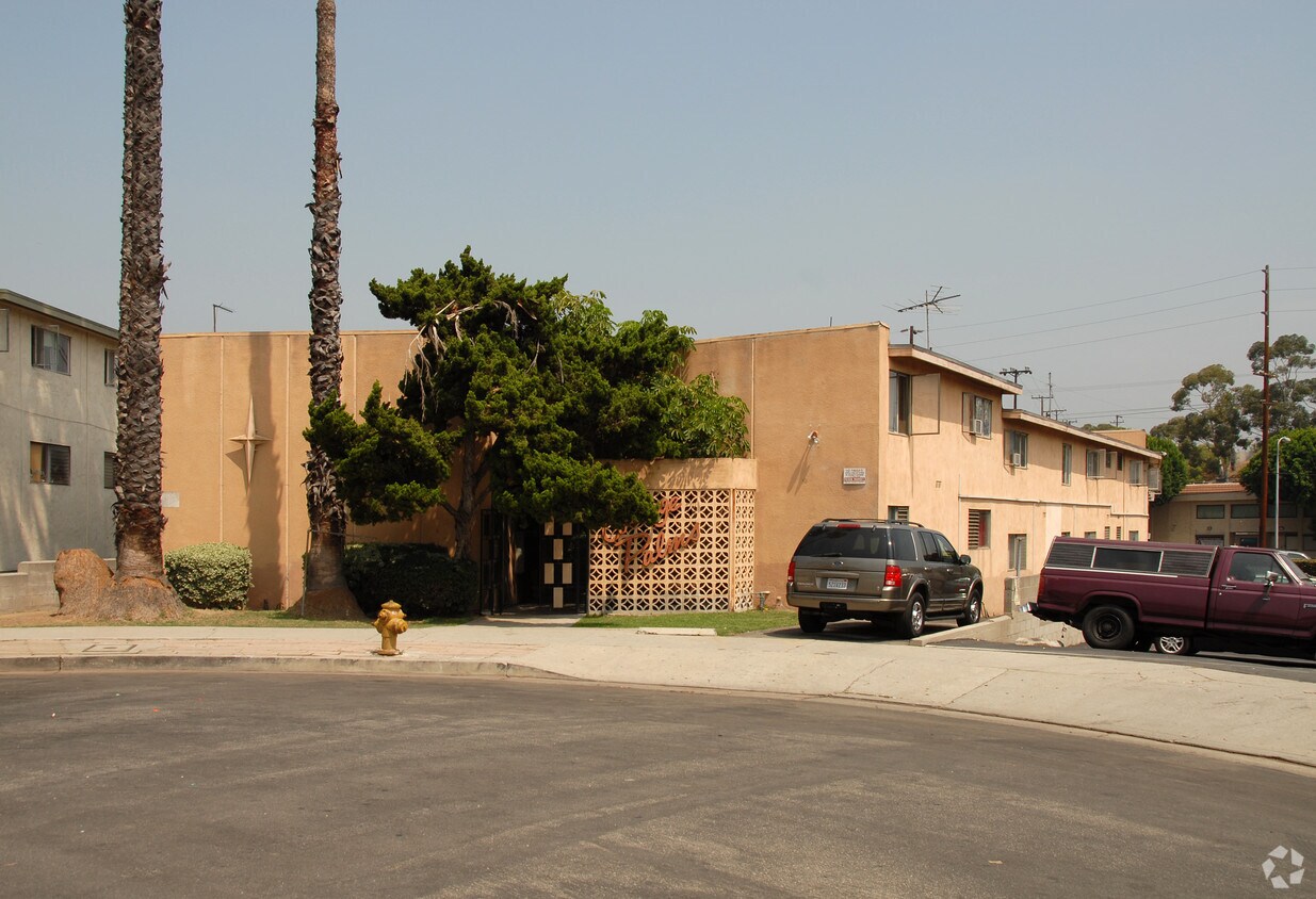
Experience your new place at College Palms Apartments in Los Angeles. Situated in the 90032 area of Los Angeles on Dobbs St., residents have easy access to great attractions nearby. From location to floorplan options, the community staff is ready and waiting to help you find your perfect place. This community offers you a wide selection of amenities and features. Some of these include: high-speed internet access, smoke free options, and convenient on-site parking options. Welcome to your new home at College Palms Apartments. Contact or drop by the leasing office to check the availability and set up a tour today.
College Palms Apartments is an apartment community located in Los Angeles County and the 90032 ZIP Code. This area is served by the Los Angeles Unified attendance zone.
High Speed Internet Access
Refrigerator
Smoke Free
Heating
Southeast Los Angeles is directly south of the Fashion District and east of the University of Southern California (USC). This large neighborhood is minutes from downtown Los Angeles, Hollywood, and Beverly Hills, with easy access to the 110 Freeway. This great location places you near sunny beaches, nature trails, and a bevy of leading employers. Students can access both USC and California State University Long Beach from their Southeast LA apartment.
This densely populated, diverse neighborhood features everything from food trucks and corner markets to wide sidewalks and residential areas filled with bungalows, ranch, and Spanish Colonial architecture. Southeast LA features palm trees and mountain views, tampered with gritty undertones to give it a cool, funky vibe.
As for outdoor fun, take your pick between Catalina Island, Venus Beach, or the Santa Monica Pier. Nearby, you’ll find more sunny beaches like White Point, Cabrillo, and Long Beach.
Learn more about living in Southeast Los Angeles| Colleges & Universities | Distance | ||
|---|---|---|---|
| Colleges & Universities | Distance | ||
| Walk: | 14 min | 0.7 mi | |
| Drive: | 8 min | 3.7 mi | |
| Drive: | 8 min | 4.3 mi | |
| Drive: | 12 min | 4.9 mi |


Transportation options available in Los Angeles include South Pasadena, located 4.1 miles from College Palms Apartments. College Palms Apartments is near Bob Hope, located 19.3 miles or 29 minutes away, and Los Angeles International, located 26.9 miles or 35 minutes away.
| Transit / Subway | Distance | ||
|---|---|---|---|
| Transit / Subway | Distance | ||
|
|
Drive: | 10 min | 4.1 mi |
| Drive: | 6 min | 4.1 mi | |
|
|
Drive: | 7 min | 4.6 mi |
|
|
Drive: | 10 min | 5.1 mi |
|
|
Drive: | 11 min | 5.9 mi |
| Commuter Rail | Distance | ||
|---|---|---|---|
| Commuter Rail | Distance | ||
|
|
Drive: | 10 min | 5.9 mi |
|
|
Drive: | 12 min | 6.1 mi |
|
|
Drive: | 13 min | 7.6 mi |
|
|
Drive: | 13 min | 8.4 mi |
| Drive: | 13 min | 9.8 mi |
| Airports | Distance | ||
|---|---|---|---|
| Airports | Distance | ||
|
Bob Hope
|
Drive: | 29 min | 19.3 mi |
|
Los Angeles International
|
Drive: | 35 min | 26.9 mi |
Time and distance from College Palms Apartments.
| Shopping Centers | Distance | ||
|---|---|---|---|
| Shopping Centers | Distance | ||
| Drive: | 4 min | 1.4 mi | |
| Drive: | 4 min | 1.7 mi | |
| Drive: | 4 min | 1.7 mi |
| Parks and Recreation | Distance | ||
|---|---|---|---|
| Parks and Recreation | Distance | ||
|
Hollenbeck Lake
|
Drive: | 10 min | 4.9 mi |
|
Audubon Center at Debs Park
|
Drive: | 12 min | 5.8 mi |
|
Chavez Ravine Arboretum
|
Drive: | 13 min | 6.7 mi |
|
Elysian Park
|
Drive: | 16 min | 6.8 mi |
|
Elyria Canyon Park
|
Drive: | 14 min | 7.3 mi |
| Hospitals | Distance | ||
|---|---|---|---|
| Hospitals | Distance | ||
| Drive: | 6 min | 2.3 mi | |
| Drive: | 6 min | 3.0 mi | |
| Drive: | 6 min | 3.2 mi |
| Military Bases | Distance | ||
|---|---|---|---|
| Military Bases | Distance | ||
| Drive: | 35 min | 24.4 mi | |
| Drive: | 32 min | 25.2 mi |
What Are Walk Score®, Transit Score®, and Bike Score® Ratings?
Walk Score® measures the walkability of any address. Transit Score® measures access to public transit. Bike Score® measures the bikeability of any address.
What is a Sound Score Rating?
A Sound Score Rating aggregates noise caused by vehicle traffic, airplane traffic and local sources
5409 Dobbs St
Los Angeles, CA 90032


 - Violet on Virgil")

 - AVA Burbank")
