
Flats of Forestville
3253 Walters Ln,
District Heights, MD 20747
1-3 Beds $1,260 - $2,060

Experience a new place to live at Cheval Court. These apartments are located in Forestville on Luana Dr. in the 20747 area. The professional leasing team will assist you in finding the perfect floorplan. At this community, you'll have access to top features and amenities. These include: convenient on-site parking options, a pet play area, and a clubhouse. It's time to find your next place. Contact or stop by the Cheval Court leasing office to check the availability and set up a tour today.
Cheval Court is an apartment community located in Prince George's County and the 20747 ZIP Code. This area is served by the Prince George's County Public Schools attendance zone.
Laundry Facilities
Clubhouse
Gated
Laundry Service
Air Conditioning
Dishwasher
High Speed Internet Access
Refrigerator
Forestville is a suburban community located less than ten miles southeast of Washington, D.C. Located along the Beltway and just north of Joint Base Andrews, Forestville is a terrific location for D.C.-area commuters as well as armed service personnel and military employees. The local rental market features a wide selection of apartments and condos, with several large shopping centers all around. Numerous large parks such as Watkins Regional Park sit nearby, and Six Flags America is just a 15 minute drive away.
Learn more about living in Forestville| Colleges & Universities | Distance | ||
|---|---|---|---|
| Colleges & Universities | Distance | ||
| Drive: | 13 min | 6.6 mi | |
| Drive: | 14 min | 7.3 mi | |
| Drive: | 17 min | 7.7 mi | |
| Drive: | 17 min | 8.8 mi |


Transportation options available in Forestville include Suitland, located 3.1 miles from Cheval Court. Cheval Court is near Ronald Reagan Washington Ntl, located 12.4 miles or 24 minutes away, and Baltimore/Washington International Thurgood Marshall, located 32.2 miles or 49 minutes away.
| Transit / Subway | Distance | ||
|---|---|---|---|
| Transit / Subway | Distance | ||
|
|
Drive: | 9 min | 3.1 mi |
|
|
Drive: | 7 min | 3.3 mi |
|
Capitol Heights, Blue/Silver Line Center Platform
|
Drive: | 9 min | 3.9 mi |
|
|
Drive: | 10 min | 4.6 mi |
|
|
Drive: | 12 min | 6.0 mi |
| Commuter Rail | Distance | ||
|---|---|---|---|
| Commuter Rail | Distance | ||
|
|
Drive: | 16 min | 7.9 mi |
|
|
Drive: | 17 min | 8.1 mi |
|
|
Drive: | 16 min | 8.3 mi |
| Drive: | 19 min | 11.0 mi | |
|
|
Drive: | 19 min | 11.0 mi |
| Airports | Distance | ||
|---|---|---|---|
| Airports | Distance | ||
|
Ronald Reagan Washington Ntl
|
Drive: | 24 min | 12.4 mi |
|
Baltimore/Washington International Thurgood Marshall
|
Drive: | 49 min | 32.2 mi |
Time and distance from Cheval Court.
| Shopping Centers | Distance | ||
|---|---|---|---|
| Shopping Centers | Distance | ||
| Walk: | 3 min | 0.2 mi | |
| Walk: | 5 min | 0.3 mi | |
| Walk: | 10 min | 0.5 mi |
| Parks and Recreation | Distance | ||
|---|---|---|---|
| Parks and Recreation | Distance | ||
|
Suitland Bog
|
Drive: | 6 min | 2.6 mi |
|
Walker Mill Regional Park
|
Drive: | 7 min | 3.2 mi |
|
Fort Dupont Park
|
Drive: | 10 min | 4.5 mi |
|
Oxon Cove Park
|
Drive: | 12 min | 5.5 mi |
|
Frederick Douglass National Historic Site
|
Drive: | 14 min | 6.5 mi |
| Hospitals | Distance | ||
|---|---|---|---|
| Hospitals | Distance | ||
| Drive: | 14 min | 6.4 mi | |
| Drive: | 15 min | 7.1 mi | |
| Drive: | 15 min | 7.5 mi |
| Military Bases | Distance | ||
|---|---|---|---|
| Military Bases | Distance | ||
| Drive: | 9 min | 4.0 mi | |
| Drive: | 15 min | 7.2 mi |
What Are Walk Score®, Transit Score®, and Bike Score® Ratings?
Walk Score® measures the walkability of any address. Transit Score® measures access to public transit. Bike Score® measures the bikeability of any address.
What is a Sound Score Rating?
A Sound Score Rating aggregates noise caused by vehicle traffic, airplane traffic and local sources
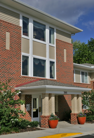
2611 Luana Dr
Forestville, MD 20747


