
The Bernice
1900 3rd St,
Sacramento, CA 95811
$1,585 - $3,150
Studio - 2 Beds

Bedrooms
Studio - 3 bd
Bathrooms
1 - 2 ba
Square Feet
522 - 1,560 sq ft
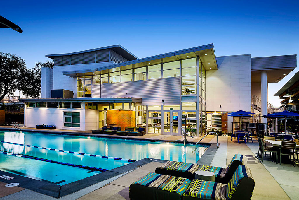
When you live at Capitol Yards, you are just steps away from Downtown Sacramento, Sutter Health Park, and riverside parks and paths. This modern, unique riverside community features exceptionally designed studio, 1-, 2-, and 3-bedroom apartment homes loaded with tech features for connection and comfort. With amenities like a demonstration kitchen, sparkling saltwater relaxation pool and lush outdoor living spaces, downtown living is really starting to take shape.
Capitol Yards is an apartment community located in Yolo County and the 95605 ZIP Code. This area is served by the Washington Unified School District attendance zone.
Unique Features
Pool
Fitness Center
Furnished Units Available
Elevator
Clubhouse
Business Center
Grill
Community-Wide WiFi
Washer/Dryer
Air Conditioning
Dishwasher
Loft Layout
High Speed Internet Access
Hardwood Floors
Walk-In Closets
Granite Countertops
Known as the city’s political and financial hub, Downtown Sacramento is a bustling district filled with historic museums and architecture, a vibrant nightlife scene, chef-driven local restaurants, and performing arts theaters. Downtown is home to the California State Capitol Park and Museum, the Crocker Art Museum, Golden 1 Center, and the Ace of Spades. Commuting in this urban neighborhood is simple with access to abundant Amtrak and light rail stations. Downtown is surrounded by the Sacramento River and the American River, as well as Interstates 5 and 80 and 16th Street. There are many modern, upscale apartments available for rent in the heart of Sacramento.
Learn more about living in Downtown Sacramento| Colleges & Universities | Distance | ||
|---|---|---|---|
| Colleges & Universities | Distance | ||
| Drive: | 8 min | 4.6 mi | |
| Drive: | 12 min | 8.0 mi | |
| Drive: | 20 min | 12.2 mi | |
| Drive: | 18 min | 12.4 mi |


Transportation options available in West Sacramento include 8Th & Capitol, located 1.2 miles from Capitol Yards. Capitol Yards is near Sacramento International, located 12.1 miles or 18 minutes away.
| Transit / Subway | Distance | ||
|---|---|---|---|
| Transit / Subway | Distance | ||
|
|
Drive: | 3 min | 1.2 mi |
|
|
Drive: | 3 min | 1.2 mi |
|
|
Drive: | 3 min | 1.3 mi |
|
|
Drive: | 3 min | 1.3 mi |
|
|
Drive: | 3 min | 1.4 mi |
| Commuter Rail | Distance | ||
|---|---|---|---|
| Commuter Rail | Distance | ||
| Drive: | 3 min | 1.2 mi | |
| Drive: | 16 min | 13.0 mi | |
|
|
Drive: | 30 min | 20.8 mi |
|
|
Drive: | 31 min | 23.0 mi |
|
|
Drive: | 46 min | 36.5 mi |
| Airports | Distance | ||
|---|---|---|---|
| Airports | Distance | ||
|
Sacramento International
|
Drive: | 18 min | 12.1 mi |
Time and distance from Capitol Yards.
| Shopping Centers | Distance | ||
|---|---|---|---|
| Shopping Centers | Distance | ||
| Walk: | 13 min | 0.7 mi | |
| Walk: | 14 min | 0.8 mi | |
| Walk: | 17 min | 0.9 mi |
| Parks and Recreation | Distance | ||
|---|---|---|---|
| Parks and Recreation | Distance | ||
|
Old Sacramento Historic District
|
Walk: | 15 min | 0.8 mi |
|
California State Railroad Museum
|
Walk: | 16 min | 0.8 mi |
|
California State Capitol Museum
|
Drive: | 3 min | 1.5 mi |
|
Leland Stanford Mansion State Historic Park
|
Drive: | 3 min | 1.6 mi |
|
Natomas Oaks Park
|
Drive: | 7 min | 4.0 mi |
| Hospitals | Distance | ||
|---|---|---|---|
| Hospitals | Distance | ||
| Drive: | 6 min | 2.8 mi | |
| Drive: | 7 min | 4.8 mi | |
| Drive: | 8 min | 5.7 mi |
| Military Bases | Distance | ||
|---|---|---|---|
| Military Bases | Distance | ||
| Drive: | 26 min | 13.5 mi |
What Are Walk Score®, Transit Score®, and Bike Score® Ratings?
Walk Score® measures the walkability of any address. Transit Score® measures access to public transit. Bike Score® measures the bikeability of any address.
What is a Sound Score Rating?
A Sound Score Rating aggregates noise caused by vehicle traffic, airplane traffic and local sources.
777 5th St
West Sacramento, CA 95605


