
1213 Walnut
1213 Walnut St,
Philadelphia, PA 19107
$2,400 - $5,544
Studio - 2 Beds

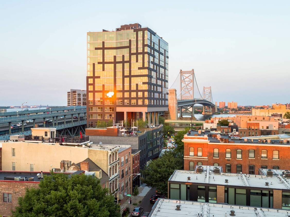
Bridge is located in the Old City neighborhood of Philadelphia, exquisitely designed for modern living. The community bridges the charm of Old City with contemporary design and amenities, tying classic aesthetics with considered, stunning architecture. Rising above the adjacent Ben Franklin Bridge and overlooking the neighborhood streets of Old City, Bridge boasts exceptional views in all directions, from 18 floors. Open layout concepts include a variety of studios, 1 and 2 bedroom floor plans.
Bridge is an apartment community located in Philadelphia County and the 19106 ZIP Code. This area is served by the The School District of Philadelphia attendance zone.
Unique Features
Fitness Center
Elevator
Concierge
Clubhouse
Roof Terrace
Controlled Access
Recycling
Business Center
Washer/Dryer
Air Conditioning
Dishwasher
High Speed Internet Access
Hardwood Floors
Walk-In Closets
Microwave
Refrigerator
It's the birthplace of the United States. It's a World Heritage City, the first in the country. It's Philadelphia's Old City, and it isn't just for tourists. This terrific neighborhood still features cobblestone streets, and the landmarks are amazing: Independence Hall, the Liberty Bell, Penn's Landing, the Benjamin Franklin Bridge, and the Betsy Ross House. Elfreth's Alley is the oldest residential street in the nation, dating back to 1702. The museums are also impressive: the Museum of the American Revolution, the National Museum of American Jewish History, the Benjamin Franklin Museum, and the Independence Seaport Museum.
But while you'll have endless destinations to take out-of-town visitors, living in Old City provides a wealth of charm, walkable streets, terrific shops and restaurants, and an outstanding farmer's market. The neighborhood is bicycle-friendly, and bicycle rentals are available at Indego stations.
Learn more about living in Old CityCompare neighborhood and city base rent averages by bedroom.
| Old City | Philadelphia, PA | |
|---|---|---|
| Studio | $1,547 | $1,407 |
| 1 Bedroom | $2,072 | $1,757 |
| 2 Bedrooms | $3,066 | $2,191 |
| 3 Bedrooms | $5,134 | $2,946 |
| Colleges & Universities | Distance | ||
|---|---|---|---|
| Colleges & Universities | Distance | ||
| Drive: | 3 min | 1.2 mi | |
| Drive: | 3 min | 1.6 mi | |
| Drive: | 6 min | 2.3 mi | |
| Drive: | 5 min | 2.8 mi |


Transportation options available in Philadelphia include 2Nd Street, located 0.3 mile from Bridge. Bridge is near Philadelphia International, located 11.4 miles or 19 minutes away, and Trenton Mercer, located 32.3 miles or 46 minutes away.
| Transit / Subway | Distance | ||
|---|---|---|---|
| Transit / Subway | Distance | ||
|
|
Walk: | 5 min | 0.3 mi |
|
|
Walk: | 10 min | 0.5 mi |
| Walk: | 10 min | 0.6 mi | |
|
|
Walk: | 12 min | 0.6 mi |
| Walk: | 15 min | 0.8 mi |
| Commuter Rail | Distance | ||
|---|---|---|---|
| Commuter Rail | Distance | ||
|
|
Walk: | 18 min | 1.0 mi |
|
|
Drive: | 4 min | 1.6 mi |
|
|
Drive: | 6 min | 2.3 mi |
|
|
Drive: | 7 min | 2.8 mi |
| Drive: | 8 min | 4.0 mi |
| Airports | Distance | ||
|---|---|---|---|
| Airports | Distance | ||
|
Philadelphia International
|
Drive: | 19 min | 11.4 mi |
|
Trenton Mercer
|
Drive: | 46 min | 32.3 mi |
Scores provided by
Traffic
BusyAirport
CalmBusinesses
ActiveScores provided by
HowLoud What is a Sound Score Rating? A Sound Score Rating aggregates noise caused by vehicle traffic, airplane traffic and local sources. How It WorksTime and distance from Bridge.
| Shopping Centers | Distance | ||
|---|---|---|---|
| Shopping Centers | Distance | ||
| Walk: | 11 min | 0.6 mi | |
| Walk: | 18 min | 1.0 mi | |
| Drive: | 4 min | 1.2 mi |
| Parks and Recreation | Distance | ||
|---|---|---|---|
| Parks and Recreation | Distance | ||
|
Lower Delaware National Wild and Scenic River
|
Walk: | 7 min | 0.4 mi |
|
Great Egg Harbor River
|
Walk: | 7 min | 0.4 mi |
|
Independence National Historical Park
|
Walk: | 11 min | 0.6 mi |
|
Independence Seaport Museum
|
Walk: | 14 min | 0.7 mi |
|
Edgar Allan Poe Nat'l Historic Site
|
Drive: | 3 min | 1.4 mi |
| Hospitals | Distance | ||
|---|---|---|---|
| Hospitals | Distance | ||
| Drive: | 3 min | 1.1 mi | |
| Drive: | 4 min | 1.3 mi | |
| Drive: | 3 min | 1.6 mi |
| Military Bases | Distance | ||
|---|---|---|---|
| Military Bases | Distance | ||
| Drive: | 10 min | 5.8 mi |
What Are Walk Score®, Transit Score®, and Bike Score® Ratings?
Walk Score® measures the walkability of any address. Transit Score® measures access to public transit. Bike Score® measures the bikeability of any address.
What is a Sound Score Rating?
A Sound Score Rating aggregates noise caused by vehicle traffic, airplane traffic and local sources.
205 Race St
Philadelphia, PA 19106


