
$1,575
/ Month
4709 N 26th Ln
Phoenix, AZ 85017
2 Weeks Ago
Favorites
4709 N 26th Ln

Favorites
Check Back Soon for Upcoming Availability
| Beds | Baths | Average SF |
|---|---|---|
| 3 Bedrooms 3 Bedrooms 3 Br | 2 Baths 2 Baths 2 Ba | 1,196 SF |
Fees and Policies
The fees below are based on community-supplied data and may exclude additional fees and utilities.
- Dogs Allowed
-
Fees not specified
- Cats Allowed
-
Fees not specified
About This Property
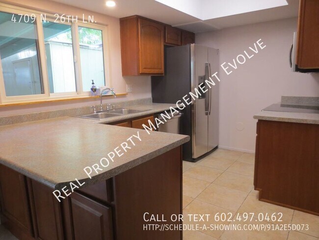
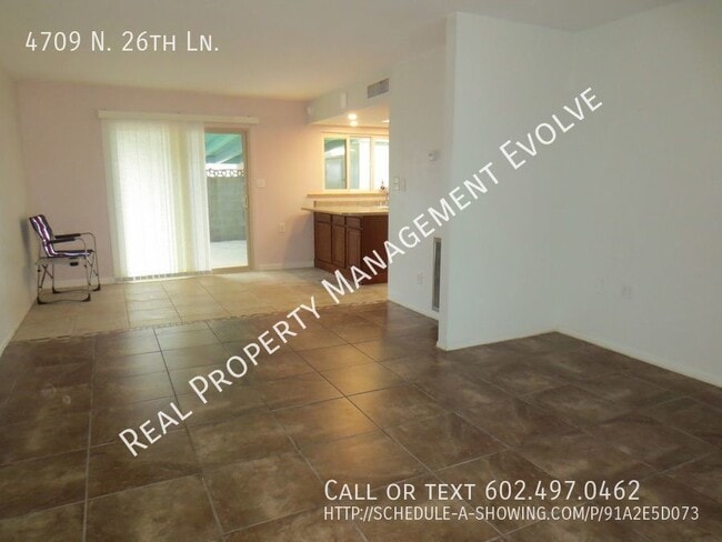
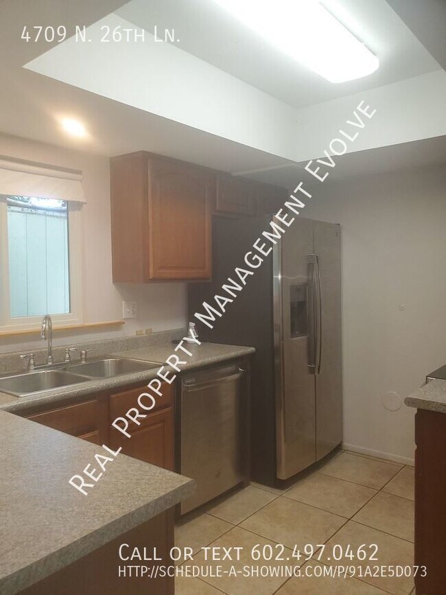
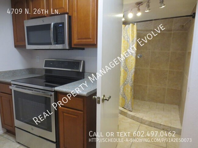
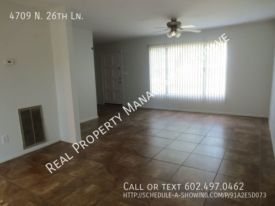
---- SCHEDULE A SHOWING ONLINE AT: ---- Clean 3 bedroom home with custom paint, tile and laminate flooring, newer stainless steel appliances and completely remodeled bathrooms (1st floor bathroom is wheelchair accessible). All 3 bedrooms are upstairs including the primary suite with a walk-in closet. Large covered back patio with storage shed. 2 covered parking spots right behind the unit and a short walk to the community pool. Beautiful community with mature landscaping in a park like setting. Great location close to I-17 and Camelback just a few minute drive from downtown! ONE SMALL DOG OR CAT WILL BE CONSIDERED. Owner requires renters Insurance Schedule a self-guided tour today at Phone:
4709 N 26th Ln is a house located in Maricopa County and the 85017 ZIP Code. This area is served by the Alhambra Elementary District attendance zone.
Location
Get Directions
Westside is a neighborhood within Glendale, which was voted “Arizona’s Antique Capital” by Sunset magazine and USA Today. Many higher education schools are located near Westside, including Glendale Community College, Carrington College, and Arizona State University West campus. You’ll discover numerous pocket parks in the area, plus larger ones like Glendale Heroes Regional Park and Grand Canal Linear Park. Shopping and dining destinations are plentiful, especially at Arrowhead Towne Center Mall.
Learn more about living in WestsideBelow are rent ranges for similar nearby apartments
Education
| Colleges & Universities | Distance | ||
|---|---|---|---|
| Colleges & Universities | Distance | ||
| Drive: | 6 min | 1.7 mi | |
| Drive: | 8 min | 3.3 mi | |
| Drive: | 9 min | 5.4 mi | |
| Drive: | 9 min | 5.4 mi |
4709 N 26th Ln is within 6 minutes or 1.7 miles from Grand Canyon University. It is also near Phoenix College and Argosy University.
Schools


Public Elementary School
Grades PK-4
857 Students
Attendance Zone
Public Elementary & Middle School
Grades 4-8
783 Students
Attendance Zone
Public High School
Grades 9-12
276 Students
Attendance Zone
Public High School
Grades 9-12
2,282 Students
Attendance Zone
Private Elementary, Middle & High School
Grades PK-12
473 Students
Nearby
Private Elementary & Middle School
Grades K-8
Nearby
Private Elementary, Middle & High School
Grades 4-11
Nearby
Private High School
Grades 9-12
372 Students
Nearby
School data provided by
 The GreatSchools Rating helps parents compare schools within a state based on a variety of school quality indicators and provides a helpful picture of how effectively each school serves all of its students. Ratings are on a scale of 1 (below average) to 10 (above average) and can include test scores, college readiness, academic progress, advanced courses, equity, discipline and attendance data. We also advise parents to visit schools, consider other information on school performance and programs, and consider family needs as part of the school selection process.
View GreatSchools Rating Methodology
Data provided by GreatSchools.org © 2025. All rights reserved.
View GreatSchools Rating Methodology
Data provided by GreatSchools.org © 2025. All rights reserved.
Transportation options available in Phoenix include 19Th Ave/Camelback, located 1.7 miles from 4709 N 26th Ln. 4709 N 26th Ln is near Phoenix Sky Harbor International, located 11.5 miles or 18 minutes away, and Phoenix-Mesa Gateway, located 38.3 miles or 51 minutes away.
| Transit / Subway | Distance | ||
|---|---|---|---|
| Transit / Subway | Distance | ||
|
|
Drive: | 4 min | 1.7 mi |
|
|
Drive: | 5 min | 2.3 mi |
|
|
Drive: | 5 min | 2.4 mi |
|
|
Drive: | 6 min | 2.7 mi |
|
|
Drive: | 6 min | 3.3 mi |
| Commuter Rail | Distance | ||
|---|---|---|---|
| Commuter Rail | Distance | ||
|
|
Drive: | 50 min | 39.4 mi |
| Airports | Distance | ||
|---|---|---|---|
| Airports | Distance | ||
|
Phoenix Sky Harbor International
|
Drive: | 18 min | 11.5 mi |
|
Phoenix-Mesa Gateway
|
Drive: | 51 min | 38.3 mi |
Time and distance from 4709 N 26th Ln.
| Shopping Centers | Distance | ||
|---|---|---|---|
| Shopping Centers | Distance | ||
| Walk: | 5 min | 0.3 mi | |
| Walk: | 14 min | 0.7 mi | |
| Walk: | 16 min | 0.9 mi |
4709 N 26th Ln has 3 shopping centers within 0.9 mile, which is about a 16-minute walk. The miles and minutes will be for the farthest away property.
| Parks and Recreation | Distance | ||
|---|---|---|---|
| Parks and Recreation | Distance | ||
|
Steele Indian School Park
|
Drive: | 8 min | 3.6 mi |
|
Maryvale Park
|
Drive: | 8 min | 4.1 mi |
|
Japanese Friendship Garden
|
Drive: | 9 min | 5.4 mi |
|
Desert Storm Park
|
Drive: | 12 min | 6.2 mi |
|
Margaret T. Hance Park
|
Drive: | 11 min | 7.0 mi |
4709 N 26th Ln has 5 parks within 7.0 miles, including Steele Indian School Park, Maryvale Park, and Desert Storm Park.
| Hospitals | Distance | ||
|---|---|---|---|
| Hospitals | Distance | ||
| Drive: | 4 min | 2.1 mi | |
| Drive: | 5 min | 2.8 mi | |
| Drive: | 8 min | 4.0 mi |
4709 N 26th Ln has 3 hospitals within 4.0 miles, the nearest is Abrazo Central Campus which is 2.1 miles away and a 4 minute drive.
| Military Bases | Distance | ||
|---|---|---|---|
| Military Bases | Distance | ||
| Drive: | 19 min | 11.4 mi | |
| Drive: | 28 min | 15.1 mi | |
| Drive: | 99 min | 74.1 mi |
4709 N 26th Ln has 3 military bases within 74.1 miles, the nearest is Phoenix Sky Harbor Airport Air Guard Station which is 11.4 miles away and a 19 minute drive.
You May Also Like
Similar Rentals Nearby
-
-
-
-
-
-
-
-
1 / 51

-
-


What Are Walk Score®, Transit Score®, and Bike Score® Ratings?
Walk Score® measures the walkability of any address. Transit Score® measures access to public transit. Bike Score® measures the bikeability of any address.
What is a Sound Score Rating?
A Sound Score Rating aggregates noise caused by vehicle traffic, airplane traffic and local sources
4709 N 26th Ln
Phoenix, AZ 85017