


$1,100
/ Month
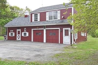
911 Tunk Hill Rd
Foster, RI 02825
2 Weeks Ago
|
Edit
Favorites
911 Tunk Hill Rd

Favorites
Check Back Soon for Upcoming Availability
| Beds | Baths | Average SF |
|---|---|---|
| 1 Bedroom 1 Bedroom 1 Br | 1 Bath 1 Bath 1 Ba | 896 SF |
Fees and Policies
The fees listed below are community-provided and may exclude utilities or add-ons. All payments are made directly to the property and are non-refundable unless otherwise specified.
- Dogs Allowed
-
Fees not specified
-
Restrictions:false
- Cats Allowed
-
Fees not specified
-
Restrictions:false
Details
Utilities Included
-
Water
-
Electricity
-
Heat
911 Tunk Hill Rd is an apartment community located in Providence County and the 02825 ZIP Code.
Features
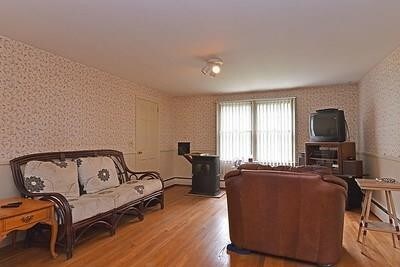
Dishwasher
Hardwood Floors
Refrigerator
Fireplace
- Security System
- Fireplace
- Dishwasher
- Range
- Refrigerator
- Hardwood Floors
- Tile Floors
- Attic
- Views
- Pool
911 Tunk Hill Rd,
Foster,
RI
02825
Amenities
- Security System
- Fireplace
- Dishwasher
- Range
- Refrigerator
- Hardwood Floors
- Tile Floors
- Attic
- Views
- Pool
Expenses
Utilities Included
Water, Electricity, Heat
Included
Education
| Colleges & Universities | Distance | ||
|---|---|---|---|
| Colleges & Universities | Distance | ||
| Drive: | 25 min | 12.4 mi | |
| Drive: | 27 min | 15.0 mi | |
| Drive: | 26 min | 15.4 mi | |
| Drive: | 31 min | 16.0 mi |
911 Tunk Hill Rd is within 25 minutes or 12.4 miles from C.C. of Rhode Island, Knight. It is also near New England Tech and Rhode Island College.
Walkability Near 911 Tunk Hill Rd Foster, RI 02825
Getting Around
 What do Walkability, Transit, Drivability, and Bikeability mean?
Walkability measures the walking distance to day-to-day needs.
Transit measures access to public transportation.
Drivability measures congestion, parking availability, and access to major roads.
Bikeability measures the suitability for cycling.
How It Works
What do Walkability, Transit, Drivability, and Bikeability mean?
Walkability measures the walking distance to day-to-day needs.
Transit measures access to public transportation.
Drivability measures congestion, parking availability, and access to major roads.
Bikeability measures the suitability for cycling.
How It Works
Not Walkable
Walkability
0
/ 100
Exceptionally Drivable
Drivability
100
/ 100
Not Bikeable
Bikeability
10
/ 100
Scores provided by
-
Soundscore™
-
/ 100
Traffic
-Airport
-Businesses
-Scores provided by
HowLoud What is a Sound Score Rating? A Sound Score Rating aggregates noise caused by vehicle traffic, airplane traffic and local sources. How It WorksYou May Also Like
Similar Rentals Nearby


What Are Walk Score®, Transit Score®, and Bike Score® Ratings?
Walk Score® measures the walkability of any address. Transit Score® measures access to public transit. Bike Score® measures the bikeability of any address.
What is a Sound Score Rating?
A Sound Score Rating aggregates noise caused by vehicle traffic, airplane traffic and local sources.

911 Tunk Hill Rd
Foster, RI 02825