9042 Belinda Blvd
Upper Marlboro, MD 20772
-
Bedrooms
3
-
Bathrooms
2.5
-
Square Feet
2,000 sq ft
-
Available
Available Now

About This Home
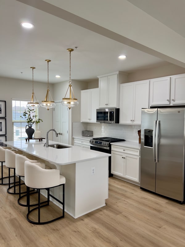
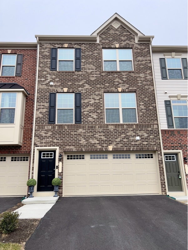
Property Id: 2107325 Newly built large townhome. Washer and dryer on the same floor as bedrooms. Will provide clean towels and clean sheets. The home is spotlessly clean. Two rooms are available for travel nurses, travel doctors, graduate students, and phD students. Both rooms have queen size beds and ample closet space and under-bed storage as well. Washer and dryer on the same floor as bedrooms. There is a backyard for grilling if you choose. The neighborhood is extremely safe and provides great amenities. Close to Washington DC and Virginia makes for nice sightseeing, dining, movie nights, and more. Close to nearby hospitals and urgent care facilities. Though there is a shared bathroom, the bathroom is shared with just 1 other person and is directly between the two rooms.
9042 Belinda Blvd is a house located in Prince George's County and the 20772 ZIP Code. This area is served by the Prince George's County Public Schools attendance zone.
House Features
Washer/Dryer
Dishwasher
Microwave
Refrigerator
- Washer/Dryer
- Dishwasher
- Disposal
- Microwave
- Oven
- Refrigerator
- Freezer
- Vinyl Flooring
Fees and Policies
The fees below are based on community-supplied data and may exclude additional fees and utilities.
Details
Utilities Included
-
Gas
-
Water
-
Electricity
-
Trash Removal
-
Sewer
Contact
- Phone Number
- Contact
-
Source

- Washer/Dryer
- Dishwasher
- Disposal
- Microwave
- Oven
- Refrigerator
- Freezer
- Vinyl Flooring
Moving to Upper Marlboro? You’ll be grateful for the close distance to nearby attractions and the sense of pride throughout the community. Located in Prince George’s County, the city is fused with urban and suburban amenities.
There’s much to enjoy about Upper Marlboro, and because it’s more intimate than other surrounding cities, it takes pride in putting on a series of events from homecoming games at local schools to show-stopping performances at the Show Place Arena. Darnall’s Chance House Museum is another city highlight that dates back to 1742.
Shopping in Upper Marlboro reflects the small, quaint ideology of the community. Fresh-baked goods and handmade crafts are purchased at the neighborhood Dutch Village Farmers Market. The distance to Washington D.C. gives residents a choice of either commuting into town by car or Metro rail.
Learn more about living in Upper Marlboro| Colleges & Universities | Distance | ||
|---|---|---|---|
| Colleges & Universities | Distance | ||
| Drive: | 13 min | 7.1 mi | |
| Drive: | 13 min | 7.6 mi | |
| Drive: | 21 min | 11.3 mi | |
| Drive: | 22 min | 11.3 mi |
 The GreatSchools Rating helps parents compare schools within a state based on a variety of school quality indicators and provides a helpful picture of how effectively each school serves all of its students. Ratings are on a scale of 1 (below average) to 10 (above average) and can include test scores, college readiness, academic progress, advanced courses, equity, discipline and attendance data. We also advise parents to visit schools, consider other information on school performance and programs, and consider family needs as part of the school selection process.
View GreatSchools Rating Methodology
Data provided by GreatSchools.org © 2025. All rights reserved.
Transportation options available in Upper Marlboro include Suitland, located 5.7 miles from 9042 Belinda Blvd. 9042 Belinda Blvd is near Ronald Reagan Washington Ntl, located 15.0 miles or 27 minutes away, and Baltimore/Washington International Thurgood Marshall, located 32.6 miles or 48 minutes away.
| Transit / Subway | Distance | ||
|---|---|---|---|
| Transit / Subway | Distance | ||
|
|
Drive: | 12 min | 5.7 mi |
|
|
Drive: | 12 min | 6.0 mi |
|
|
Drive: | 12 min | 6.3 mi |
|
|
Drive: | 12 min | 7.0 mi |
|
|
Drive: | 13 min | 7.2 mi |
| Commuter Rail | Distance | ||
|---|---|---|---|
| Commuter Rail | Distance | ||
| Drive: | 18 min | 11.4 mi | |
|
|
Drive: | 18 min | 11.4 mi |
|
|
Drive: | 21 min | 11.6 mi |
|
|
Drive: | 19 min | 11.7 mi |
|
|
Drive: | 22 min | 11.7 mi |
| Airports | Distance | ||
|---|---|---|---|
| Airports | Distance | ||
|
Ronald Reagan Washington Ntl
|
Drive: | 27 min | 15.0 mi |
|
Baltimore/Washington International Thurgood Marshall
|
Drive: | 48 min | 32.6 mi |
Time and distance from 9042 Belinda Blvd.
| Shopping Centers | Distance | ||
|---|---|---|---|
| Shopping Centers | Distance | ||
| Drive: | 5 min | 2.3 mi | |
| Drive: | 5 min | 2.3 mi | |
| Drive: | 5 min | 2.5 mi |
| Parks and Recreation | Distance | ||
|---|---|---|---|
| Parks and Recreation | Distance | ||
|
Suitland Bog
|
Drive: | 7 min | 3.3 mi |
|
Walker Mill Regional Park
|
Drive: | 10 min | 5.3 mi |
|
Rosaryville State Park
|
Drive: | 15 min | 7.4 mi |
|
Watkins Nature Center
|
Drive: | 14 min | 9.3 mi |
|
Watkins Regional Park
|
Drive: | 18 min | 9.9 mi |
| Hospitals | Distance | ||
|---|---|---|---|
| Hospitals | Distance | ||
| Drive: | 17 min | 8.5 mi | |
| Drive: | 15 min | 8.6 mi | |
| Drive: | 18 min | 9.2 mi |
| Military Bases | Distance | ||
|---|---|---|---|
| Military Bases | Distance | ||
| Drive: | 9 min | 3.5 mi | |
| Drive: | 18 min | 9.8 mi |
You May Also Like
What Are Walk Score®, Transit Score®, and Bike Score® Ratings?
Walk Score® measures the walkability of any address. Transit Score® measures access to public transit. Bike Score® measures the bikeability of any address.
What is a Sound Score Rating?
A Sound Score Rating aggregates noise caused by vehicle traffic, airplane traffic and local sources


