

$1,600
/ Month
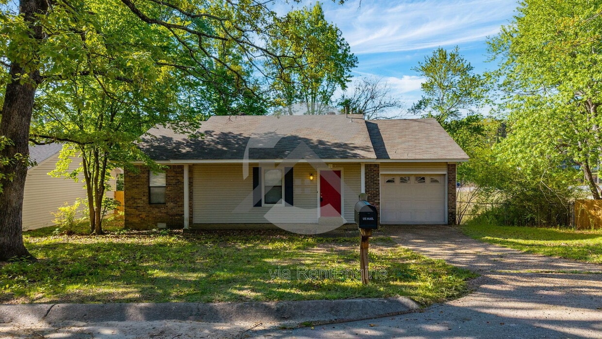
9 Point W Cir
Little Rock, AR 72211
Today
|
Edit
Favorites
501-566-6414
-
Bedrooms
3
-
Bathrooms
2
-
Square Feet
1,218 sq ft
-
Available
Available Now
9 Point W Cir

Favorites
About This Home
Available Now
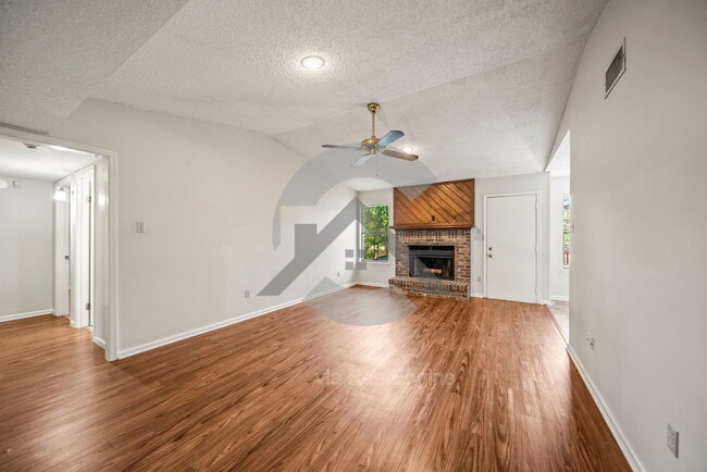
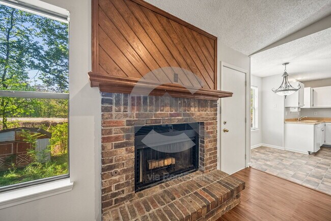
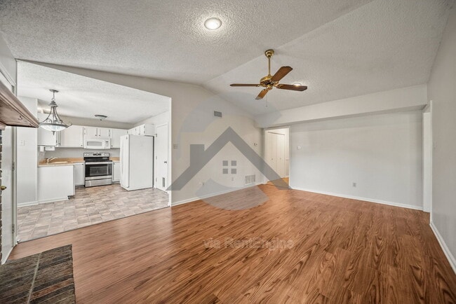
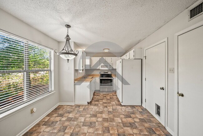
Come take a look at this 3-bedroom, 2-bath home in West Little Rock, conveniently located near shopping, restaurants, and grocery stores. The layout offers comfortable living space along with a one-car garage for added convenience. Out back, you'll find a fully fenced yard with a large raised deck—perfect for relaxing or enjoying time outdoors. The home is in a great location for easy day-to-day living while still offering a bit of privacy. Up to two pets are welcome with a 25 lb weight limit and an additional monthly fee. Schedule your tour today and see if this home is the right fit for you. By submitting your information on this page you consent to being contacted by the Property Manager and RentEngine via SMS, phone, or email.
9 Point W Cir is a house located in Pulaski County and the 72211 ZIP Code. This area is served by the Lisa Academy Charter attendance zone.
* Price shown is base rent. Excludes user-selected optional fees and variable or usage-based fees and required charges due at or prior to move-in or at move-out. Price, availability, fees, and any applicable rent special are subject to change without notice.
* Square footage definitions vary. Displayed square footage is approximate.
House Features
Dishwasher
Microwave
Fireplace
Range
- Fireplace
- Dishwasher
- Microwave
- Range
Contact
- Listed by Clear | Clear Property Management by Elite PM
- Phone Number
- Contact
Location
Get Directions
West Little Rock is comprised of a vast swath of land stretching from Interstate 430 out towards Williams Junction and over Lake Maumelle. There’s an incredible variety of neighborhoods, communities, and landscapes in what’s considered West Little Rock, including waterfront communities on the lake, pastoral reprieves of the Arkansas countryside, and the more suburban communities nearing the city center. There’s a little something for everyone in West Little Rock, but most renters will be enticed by the apartment communities and affordable renters just west of the Interstate that mix the serenity of living outside the city while still being close enough to enjoy its amenities.
Learn more about living in West Little Rock
Amenities
- Fireplace
- Dishwasher
- Microwave
- Range
Education
| Colleges & Universities | Distance | ||
|---|---|---|---|
| Colleges & Universities | Distance | ||
| Drive: | 11 min | 6.1 mi | |
| Drive: | 12 min | 6.3 mi | |
| Drive: | 13 min | 8.3 mi | |
| Drive: | 23 min | 14.9 mi |
9 Point W Cir is within 11 minutes or 6.1 miles from UA Little Rock. It is also near Univ. of Ark. Medical Scis. and Philander Smith College.
Schools


Public Elementary School
Grades K-5
556 Students
Nearby
Public Middle School
Grades 6-8
1,352 Students
Nearby
School data provided by
 The GreatSchools Rating helps parents compare schools within a state based on a variety of school quality indicators and provides a helpful picture of how effectively each school serves all of its students. Ratings are on a scale of 1 (below average) to 10 (above average) and can include test scores, college readiness, academic progress, advanced courses, equity, discipline and attendance data. We also advise parents to visit schools, consider other information on school performance and programs, and consider family needs as part of the school selection process.
View GreatSchools Rating Methodology
Data provided by GreatSchools.org © 2026. All rights reserved.
View GreatSchools Rating Methodology
Data provided by GreatSchools.org © 2026. All rights reserved.
Transportation options available in Little Rock include 2Nd St & Center St, located 9.1 miles from 9 Point W Cir. 9 Point W Cir is near Bill and Hillary Clinton Ntl/Adams Field, located 12.9 miles or 20 minutes away.
| Transit / Subway | Distance | ||
|---|---|---|---|
| Transit / Subway | Distance | ||
| Drive: | 14 min | 9.1 mi | |
| Drive: | 14 min | 9.1 mi | |
| Drive: | 14 min | 9.4 mi | |
| Drive: | 14 min | 9.5 mi | |
| Drive: | 15 min | 9.8 mi |
| Commuter Rail | Distance | ||
|---|---|---|---|
| Commuter Rail | Distance | ||
|
|
Drive: | 14 min | 8.2 mi |
|
|
Drive: | 49 min | 41.5 mi |
| Airports | Distance | ||
|---|---|---|---|
| Airports | Distance | ||
|
Bill and Hillary Clinton Ntl/Adams Field
|
Drive: | 20 min | 12.9 mi |
Getting Around
 What do Walkability, Transit, Drivability, and Bikeability mean?
Walkability measures the walking distance to day-to-day needs.
Transit measures access to public transportation.
Drivability measures congestion, parking availability, and access to major roads.
Bikeability measures the suitability for cycling.
How It Works
What do Walkability, Transit, Drivability, and Bikeability mean?
Walkability measures the walking distance to day-to-day needs.
Transit measures access to public transportation.
Drivability measures congestion, parking availability, and access to major roads.
Bikeability measures the suitability for cycling.
How It Works
Fairly Walkable
Walkability
50
/ 100
Limited Public Transit
Transit
20
/ 100
Exceptionally Drivable
Drivability
90
/ 100
Somewhat Bikeable
Bikeability
30
/ 100
Scores provided by
Active
Soundscore™
77
/ 100
Traffic
ActiveAirport
CalmBusinesses
CalmScores provided by
HowLoud What is a Sound Score Rating? A Sound Score Rating aggregates noise caused by vehicle traffic, airplane traffic and local sources. How It WorksTime and distance from 9 Point W Cir.
| Shopping Centers | Distance | ||
|---|---|---|---|
| Shopping Centers | Distance | ||
| Walk: | 9 min | 0.5 mi | |
| Walk: | 11 min | 0.6 mi | |
| Walk: | 12 min | 0.7 mi |
9 Point W Cir has 3 shopping centers within 0.7 mile, which is about a 12-minute walk. The miles and minutes will be for the farthest away property.
| Parks and Recreation | Distance | ||
|---|---|---|---|
| Parks and Recreation | Distance | ||
|
Little Rock Zoo
|
Drive: | 9 min | 5.5 mi |
|
Central High School National Historic Site
|
Drive: | 12 min | 7.3 mi |
|
Museum of Discovery
|
Drive: | 14 min | 9.6 mi |
|
Pinnacle Mountain State Park
|
Drive: | 23 min | 10.7 mi |
|
Burns Park
|
Drive: | 19 min | 12.1 mi |
9 Point W Cir has 5 parks within 12.1 miles, including Little Rock Zoo, Central High School National Historic Site, and Museum of Discovery.
| Hospitals | Distance | ||
|---|---|---|---|
| Hospitals | Distance | ||
| Drive: | 4 min | 1.6 mi | |
| Drive: | 10 min | 5.9 mi | |
| Drive: | 10 min | 6.1 mi |
9 Point W Cir has 3 hospitals within 6.1 miles, the nearest is Arkansas Heart Hospital which is 1.6 miles away and a 4 minute drive.
| Military Bases | Distance | ||
|---|---|---|---|
| Military Bases | Distance | ||
| Drive: | 34 min | 19.2 mi | |
| Drive: | 39 min | 26.8 mi | |
| Drive: | 42 min | 27.2 mi |
9 Point W Cir has 3 military bases within 27.2 miles, the nearest is Camp Joseph T. Robinson Hill which is 19.2 miles away and a 34 minute drive.
You May Also Like
Similar Rentals Nearby


What Are Walk Score®, Transit Score®, and Bike Score® Ratings?
Walk Score® measures the walkability of any address. Transit Score® measures access to public transit. Bike Score® measures the bikeability of any address.
What is a Sound Score Rating?
A Sound Score Rating aggregates noise caused by vehicle traffic, airplane traffic and local sources.
9 Point W Cir
Little Rock, AR 72211