
Velo Forest Hills Apartments
3686 Washington St,
Boston, MA 02130
$2,780 - $4,760 Total Monthly Price
Studio - 3 Beds

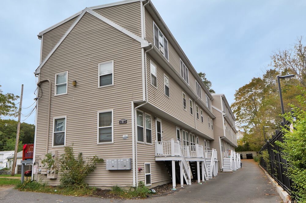
Find your new apartment at 875-889 American Legion Hwy in Roslindale, MA. You'll find this community at 875-889 American Legion Hwy. in Roslindale. Let the knowledgeable leasing staff show you everything this community has in store. Stop looking and get moving. Contact or stop by 875-889 American Legion Hwy to see available floor plans!
875-889 American Legion Hwy is an apartment community located in Suffolk County and the 02131 ZIP Code. This area is served by the Boston Public Schools attendance zone.
Air Conditioning
High Speed Internet Access
Hardwood Floors
Patio
Lower Washington-Mount Hope is a walkable neighborhood about eight miles south of Boston via Interstate 93 or public transit. Despite this area’s dense population, Lower Washington-Mount Hope has many wooded areas, and large parks like Bussey Brook Meadow and Franklin Park surround the neighborhood. Along with residential neighborhoods, a few shops and eateries can be found in town along American Legion Highway. Many residents travel to the western corner of town to get to the shopping plaza off Corinth Street for all the necessities. The western part of the neighborhood is also where most of the rentals in this area are located. Apartments, condos, and townhomes ranging from moderately priced to luxury can be found here.
Learn more about living in Lower Washington-Mount HopeCompare neighborhood and city base rent averages by bedroom.
| Lower Washington-Mount Hope | Roslindale, MA | |
|---|---|---|
| Studio | $2,243 | $1,879 |
| 1 Bedroom | $2,206 | $2,263 |
| 2 Bedrooms | $2,554 | $2,734 |
| 3 Bedrooms | $3,233 | $3,658 |
| Colleges & Universities | Distance | ||
|---|---|---|---|
| Colleges & Universities | Distance | ||
| Drive: | 9 min | 3.3 mi | |
| Drive: | 10 min | 4.8 mi | |
| Drive: | 10 min | 5.3 mi | |
| Drive: | 10 min | 5.4 mi |


Transportation options available in Roslindale include Forest Hills Station, located 1.9 miles from 875-889 American Legion Hwy. 875-889 American Legion Hwy is near General Edward Lawrence Logan International, located 10.1 miles or 20 minutes away.
| Transit / Subway | Distance | ||
|---|---|---|---|
| Transit / Subway | Distance | ||
|
|
Drive: | 4 min | 1.9 mi |
|
|
Drive: | 5 min | 2.1 mi |
|
|
Drive: | 6 min | 2.7 mi |
|
|
Drive: | 6 min | 2.8 mi |
|
|
Drive: | 7 min | 3.3 mi |
| Commuter Rail | Distance | ||
|---|---|---|---|
| Commuter Rail | Distance | ||
|
|
Drive: | 5 min | 1.5 mi |
| Drive: | 4 min | 1.7 mi | |
|
|
Drive: | 4 min | 1.8 mi |
|
|
Drive: | 4 min | 1.9 mi |
|
|
Drive: | 6 min | 2.6 mi |
| Airports | Distance | ||
|---|---|---|---|
| Airports | Distance | ||
|
General Edward Lawrence Logan International
|
Drive: | 20 min | 10.1 mi |
Scores provided by
Traffic
-Airport
-Businesses
-Scores provided by
HowLoud What is a Sound Score Rating? A Sound Score Rating aggregates noise caused by vehicle traffic, airplane traffic and local sources. How It WorksTime and distance from 875-889 American Legion Hwy.
| Shopping Centers | Distance | ||
|---|---|---|---|
| Shopping Centers | Distance | ||
| Walk: | 5 min | 0.3 mi | |
| Walk: | 12 min | 0.6 mi | |
| Walk: | 16 min | 0.9 mi |
| Parks and Recreation | Distance | ||
|---|---|---|---|
| Parks and Recreation | Distance | ||
|
Mass Audubon's Boston Nature Center and Wildlife Sanctuary
|
Drive: | 5 min | 1.6 mi |
|
Arnold Arboretum of Harvard University
|
Drive: | 7 min | 2.4 mi |
|
Stony Brook Reservation
|
Drive: | 7 min | 2.9 mi |
|
Franklin Park Zoo
|
Drive: | 8 min | 2.9 mi |
|
Lower Neponset River Trail
|
Drive: | 8 min | 3.1 mi |
| Hospitals | Distance | ||
|---|---|---|---|
| Hospitals | Distance | ||
| Drive: | 8 min | 3.1 mi | |
| Drive: | 8 min | 3.3 mi | |
| Drive: | 6 min | 3.5 mi |
| Military Bases | Distance | ||
|---|---|---|---|
| Military Bases | Distance | ||
| Drive: | 31 min | 15.0 mi | |
| Drive: | 38 min | 20.5 mi | |
| Drive: | 45 min | 26.4 mi |
Pets Allowed Fitness Center In Unit Washer & Dryer Balcony Elevator Rooftop Deck
Pets Allowed Maintenance on site Heat Controlled Access Elevator Laundry Facilities
Pets Allowed Fitness Center Pool Dishwasher Kitchen In Unit Washer & Dryer
Fitness Center High-Speed Internet Stainless Steel Appliances Package Service Granite Countertops Elevator
Pets Allowed Fitness Center Dishwasher Refrigerator Kitchen In Unit Washer & Dryer
Fitness Center Clubhouse Balcony Granite Countertops Smoke Free Basketball Court
What Are Walk Score®, Transit Score®, and Bike Score® Ratings?
Walk Score® measures the walkability of any address. Transit Score® measures access to public transit. Bike Score® measures the bikeability of any address.
What is a Sound Score Rating?
A Sound Score Rating aggregates noise caused by vehicle traffic, airplane traffic and local sources.
875-889 American Legion Hwy
Roslindale, MA 02131


