

$2,150
/ Month
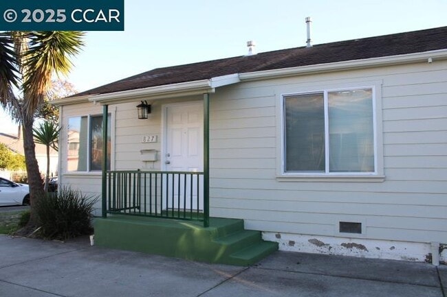
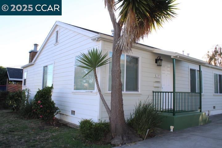
827 S 33rd St
Richmond, CA 94804
Today
|
Edit
Favorites
510-236-8366
-
Bedrooms
2
-
Bathrooms
1
-
Square Feet
731 sq ft
-
Available
Available Now
Highlights
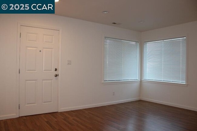
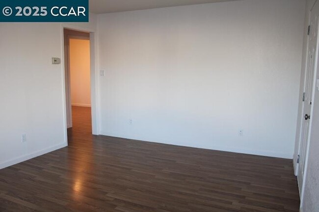
- Wood Flooring
- No Cooling
- Tile Flooring
- Garage
- Wall Furnace
- 1-Story Property
827 S 33rd St

Favorites
About This Home
Available Now
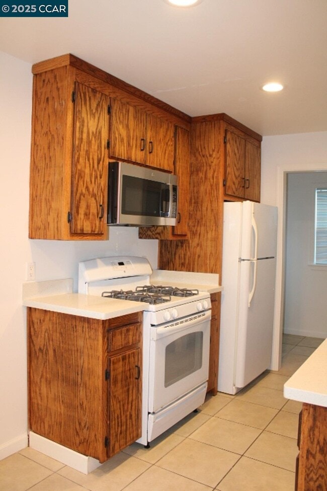
Two Bedroom/ 1 Bath Unit in a Duplex w/ 1 Parking Space available in Front of Garage. Hardwood & tile floors. Stove/oven,refrigerator & Microwave/hood. Window coverings. Washer/dryer hook-ups. Back patio. Owner pays garbage. Approx. Sq. Ft. 731. No pets. No Smoking. Sec. Dep. $2,150. ONE YEAR LEASE.
827 S 33rd St is a townhome located in Contra Costa County and the 94804 ZIP Code. This area is served by the West Contra Costa Unified attendance zone.
* Price shown is base rent. Excludes user-selected optional fees and variable or usage-based fees and required charges due at or prior to move-in or at move-out. Price, availability, fees, and any applicable rent special are subject to change without notice.
* Square footage definitions vary. Displayed square footage is approximate.
Home Details
Home Type
Duplex
Year Built
Built in 1944
Bedrooms and Bathrooms
1 Full Bathroom
2 Bedrooms
Flooring
Wood
Tile
Interior Spaces
1-Story Property
Kitchen
Gas Range
Free-Standing Range
Microwave
Laundry
Laundry in unit
Washer and Dryer Hookup
Listing and Financial Details
Assessor Parcel Number 5241400117
Lot Details
5,000 Sq Ft Lot
Parking
Garage
No Garage
Utilities
No Cooling
Wall Furnace
Community Details
Overview
No Home Owners Association
Ne Richmond Subdivision
Contact
- Listed by Lynette Bartels | Bartels Property Management
- Phone Number
- Contact
-
Source
 Contra Costa Association of REALTORS®
Copyright © 2025 Bay East, CCAR, bridgeMLS. Based on information from Bay East and Contra Costa Association of REALTORS® and bridgeMLS. All data, including all measurements and calculations of area, is obtained from various sources and has not been, and will not be, verified by broker or MLS. All information should be independently reviewed and verified for accuracy. If a floor plan is included, the floor plan is for illustrative purposes only, and the actual dimensions and layout of the home may differ from the floor plan. Buyer is urged to make a detailed inspection of the property, and if any aspect of a floor plan is critical to the buyer's decision to purchase, buyer must conduct their own measurements and inspection. Properties may or may not be listed by the office/agent presenting the information.
Location
Get Directions
With reasonable rents and a great deal of community spirit, the North and East neighborhood of Richmond proves itself ideal for residents who want to be active in community groups and who thrive on a little bit of urban grit. Community involvement runs strong here in this neighborhood that sits only 10 to 15 minutes away from the quirky scene in Berkeley.
When you want a break from city life, Wildcat Canyon Regional Park sits less than a mile from the east edge of North and East. Bring your mountain bike or just hike through the 2,400-acre park centered on Wildcat Creek. When you have to get back to work, AC Transit, BART, and the transbay buses can get you to Oakland, 11 miles away, or even across the Bay to San Francisco and places beyond.
Learn more about living in North & East
Education
| Colleges & Universities | Distance | ||
|---|---|---|---|
| Colleges & Universities | Distance | ||
| Drive: | 6 min | 2.7 mi | |
| Drive: | 15 min | 8.3 mi | |
| Drive: | 18 min | 9.3 mi | |
| Drive: | 15 min | 10.9 mi |
827 S 33rd St is within 6 minutes or 2.7 miles from Contra Costa College. It is also near Berkeley City College and UC Berkeley.
Schools


Public Elementary School
Grades K-6
431 Students
Attendance Zone
Public Elementary School
Grades K-5
270 Students
Nearby
Public Middle School
Grades 7-8
404 Students
Attendance Zone
Public High School
Grades 9-12
823 Students
Attendance Zone
Private Elementary & Middle School
Grades K-8
45 Students
Nearby
Private Elementary, Middle & High School
Grades PK-12
Nearby
Private High School
Grades 9-12
394 Students
Nearby
School data provided by
 The GreatSchools Rating helps parents compare schools within a state based on a variety of school quality indicators and provides a helpful picture of how effectively each school serves all of its students. Ratings are on a scale of 1 (below average) to 10 (above average) and can include test scores, college readiness, academic progress, advanced courses, equity, discipline and attendance data. We also advise parents to visit schools, consider other information on school performance and programs, and consider family needs as part of the school selection process.
View GreatSchools Rating Methodology
Data provided by GreatSchools.org © 2025. All rights reserved.
View GreatSchools Rating Methodology
Data provided by GreatSchools.org © 2025. All rights reserved.
Transportation options available in Richmond include Richmond Station, located 1.4 miles from 827 S 33rd St. 827 S 33rd St is near Metro Oakland International, located 21.3 miles or 29 minutes away, and San Francisco International, located 28.9 miles or 42 minutes away.
| Transit / Subway | Distance | ||
|---|---|---|---|
| Transit / Subway | Distance | ||
|
|
Drive: | 3 min | 1.4 mi |
|
|
Drive: | 4 min | 1.9 mi |
|
|
Drive: | 4 min | 2.0 mi |
|
|
Drive: | 7 min | 4.0 mi |
|
|
Drive: | 13 min | 7.7 mi |
| Commuter Rail | Distance | ||
|---|---|---|---|
| Commuter Rail | Distance | ||
| Drive: | 4 min | 1.6 mi | |
|
|
Drive: | 10 min | 6.9 mi |
|
|
Drive: | 13 min | 8.7 mi |
| Drive: | 20 min | 11.7 mi | |
| Drive: | 20 min | 12.7 mi |
| Airports | Distance | ||
|---|---|---|---|
| Airports | Distance | ||
|
Metro Oakland International
|
Drive: | 29 min | 21.3 mi |
|
San Francisco International
|
Drive: | 42 min | 28.9 mi |
Time and distance from 827 S 33rd St.
| Shopping Centers | Distance | ||
|---|---|---|---|
| Shopping Centers | Distance | ||
| Walk: | 8 min | 0.4 mi | |
| Walk: | 12 min | 0.6 mi | |
| Drive: | 3 min | 1.3 mi |
827 S 33rd St has 3 shopping centers within 1.3 miles, which is about a 3-minute walk. The miles and minutes will be for the farthest away property.
| Parks and Recreation | Distance | ||
|---|---|---|---|
| Parks and Recreation | Distance | ||
|
Marina Park & Green
|
Drive: | 6 min | 2.9 mi |
|
Rosie the Riveter WWII Home Front National Historical Park
|
Drive: | 7 min | 3.4 mi |
|
Shimada Friendship Park
|
Drive: | 7 min | 3.4 mi |
|
Wildcat Canyon Regional Park
|
Drive: | 11 min | 4.6 mi |
|
Point Isabel Regional Shoreline
|
Drive: | 10 min | 4.6 mi |
827 S 33rd St has 5 parks within 4.6 miles, including Marina Park & Green, Rosie the Riveter WWII Home Front National Historical Park, and Shimada Friendship Park.
| Hospitals | Distance | ||
|---|---|---|---|
| Hospitals | Distance | ||
| Drive: | 17 min | 9.9 mi | |
| Drive: | 15 min | 10.8 mi | |
| Drive: | 15 min | 10.8 mi |
827 S 33rd St has 3 hospitals within 10.8 miles, the nearest is Alta Bates Summit Medical Center - Alta Bates Campus which is 9.9 miles away and a 17 minute drive.
| Military Bases | Distance | ||
|---|---|---|---|
| Military Bases | Distance | ||
| Drive: | 6 min | 2.5 mi | |
| Drive: | 10 min | 4.7 mi | |
| Drive: | 23 min | 14.9 mi |
827 S 33rd St has 3 military bases within 14.9 miles, the nearest is Armory West Contra Costa which is 2.5 miles away and a 6 minute drive.
You May Also Like
Similar Rentals Nearby


What Are Walk Score®, Transit Score®, and Bike Score® Ratings?
Walk Score® measures the walkability of any address. Transit Score® measures access to public transit. Bike Score® measures the bikeability of any address.
What is a Sound Score Rating?
A Sound Score Rating aggregates noise caused by vehicle traffic, airplane traffic and local sources
827 S 33rd St
Richmond, CA 94804