


$4,000 / Month
82 Crescent St
Auburndale, MA 02466
Today
Favorites
857-275-5146
-
Bedrooms
3
-
Bathrooms
2
-
Square Feet
1,400 sq ft
-
Available
Available Jun 19
Highlight
- Pets Allowed
82 Crescent St

Favorites
About This Home
$4,000 deposit,
Available Jun 19
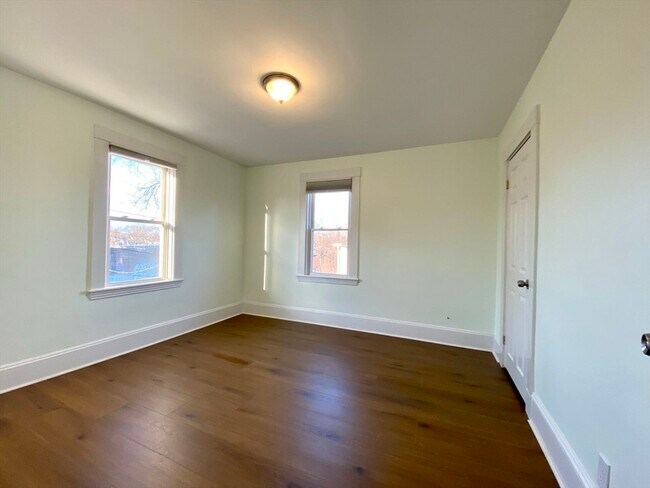
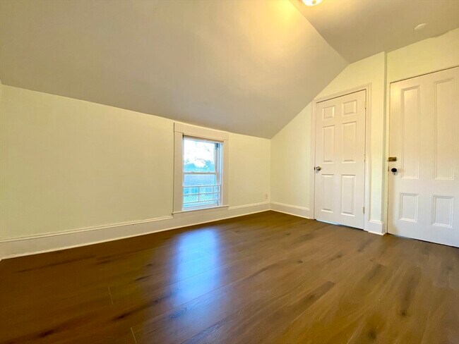
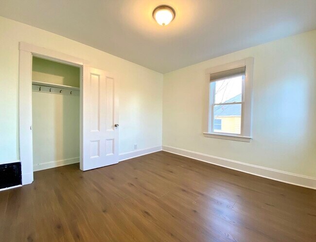
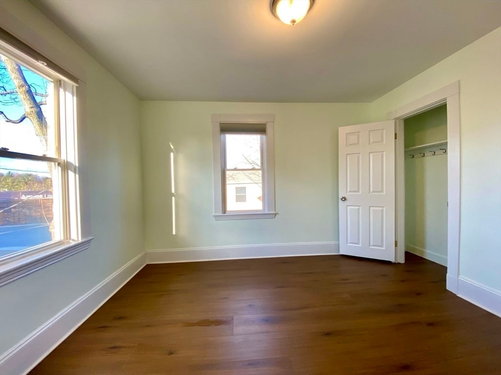
Stunning Duplex in Prime Newton Location,Beautifully situated in a highly sought-after,safe,and tranquil neighborhood,this spacious duplex offers the perfect blend of comfort and convenience. Excellent commuter location just a short walk to West Newton commuter rail,Express Bus,and Woodland Station (Green D Line "T"). Quick access to Mass Pike (I-90) allows you to drive to downtown Boston in just 15 minutes. Enjoy outdoor leisure along Route 30's carriage lane or near Lasell University,perfect for walking,jogging,or biking. Walking distance to Auburndale Center,local shops,restaurants,and supermarket. Located within the top-rated Newton public school district. New roof (2019) and newer gas heating system & hot water tanks,Move-in costs: First month,last month,security deposit,and broker fee required. MLS# 73391818
82 Crescent St is a townhome located in Middlesex County and the 02466 ZIP Code. This area is served by the Newton attendance zone.
* Price shown is base rent and may not include non-optional fees and utilities.
Price, availability, fees, and any applicable rent special are subject to change without notice.
* Square footage definitions vary. Displayed square footage is approximate.
Fees and Policies
The fees below are based on community-supplied data and may exclude additional fees and utilities.
- Dogs Allowed
-
Fees not specified
- Cats Allowed
-
Fees not specified
Contact
- Listed by Meina Jing | Peace of Mind Realty
- Phone Number
-
Source
 MLS Property Information Network
The property listing data and information set forth herein were provided to MLS Property Information Network, Inc. from third party sources, including sellers, lessors and public records, and were compiled by MLS Property Information Network, Inc. The property listing data and information are for the personal, non-commercial use of consumers having a good faith interest in purchasing or leasing listed properties of the type displayed to them and may not be used for any purpose other than to identify prospective properties which such consumers may have a good faith interest in purchasing or leasing. MLS Property Information Network, Inc. and its subscribers disclaim any and all representations and warranties as to the accuracy of the property listing data and information set forth herein. All properties are subject to prior sale, change or withdrawal. Copyright © 2025 MLS Property Information Network, Inc. All rights reserved.
Location
Get Directions
Auburndale, affectionately referred to as “The Dale” by locals, is one of 13 villages in the City of Newton. Situated near the intersection of Interstates 90 and 95, the Dale is surrounded by the City of Waltham and the Charles River as well as three other Newton villages including West Newton, Waban, and Newton Lower Falls. Getting around from the Dale is simple with access to the MBTA commuter rail.
The western end of Auburndale is well known for containing two historic parks, Norumbega Park and the Auburndale Cove Park and Playground, which offer plenty of options for outdoor recreation. The Auburndale Historic District is comprised of about 275 properties, many of which are on the National Register of Historic Places. Treasured resources like the Auburndale Community Library and Lasell College provide learning opportunities for the community.
Learn more about living in Auburndale
Education
| Colleges & Universities | Distance | ||
|---|---|---|---|
| Colleges & Universities | Distance | ||
| Drive: | 8 min | 3.4 mi | |
| Drive: | 10 min | 4.3 mi | |
| Drive: | 9 min | 4.9 mi | |
| Drive: | 12 min | 5.5 mi |
82 Crescent St is within 8 minutes or 3.4 miles from Brandeis University. It is also near Bentley University and Boston College.
Schools


Public Elementary School
Grades K-5
231 Students
Attendance Zone
Public Elementary School
Grades PK-5
383 Students
Nearby
Public Middle School
Grades 6-8
750 Students
Attendance Zone
Public High School
Grades 9-12
1,837 Students
Attendance Zone
Private Elementary, Middle & High School
Grades 3-12
161 Students
Nearby
Private Elementary & Middle School
Grades PK-9
517 Students
Nearby
School data provided by
 The GreatSchools Rating helps parents compare schools within a state based on a variety of school quality indicators and provides a helpful picture of how effectively each school serves all of its students. Ratings are on a scale of 1 (below average) to 10 (above average) and can include test scores, college readiness, academic progress, advanced courses, equity, discipline and attendance data. We also advise parents to visit schools, consider other information on school performance and programs, and consider family needs as part of the school selection process.
View GreatSchools Rating Methodology
Data provided by GreatSchools.org © 2025. All rights reserved.
View GreatSchools Rating Methodology
Data provided by GreatSchools.org © 2025. All rights reserved.
Transportation options available in Auburndale include Woodland Station, located 1.3 miles from 82 Crescent St. 82 Crescent St is near General Edward Lawrence Logan International, located 13.5 miles or 21 minutes away, and Worcester Regional, located 39.2 miles or 56 minutes away.
| Transit / Subway | Distance | ||
|---|---|---|---|
| Transit / Subway | Distance | ||
|
|
Drive: | 3 min | 1.3 mi |
|
|
Drive: | 4 min | 1.3 mi |
|
|
Drive: | 5 min | 2.4 mi |
|
|
Drive: | 7 min | 3.1 mi |
|
|
Drive: | 7 min | 3.6 mi |
| Commuter Rail | Distance | ||
|---|---|---|---|
| Commuter Rail | Distance | ||
| Drive: | 6 min | 2.6 mi | |
|
|
Drive: | 6 min | 3.0 mi |
|
|
Drive: | 7 min | 4.3 mi |
|
|
Drive: | 9 min | 5.7 mi |
|
|
Drive: | 10 min | 6.5 mi |
| Airports | Distance | ||
|---|---|---|---|
| Airports | Distance | ||
|
General Edward Lawrence Logan International
|
Drive: | 21 min | 13.5 mi |
|
Worcester Regional
|
Drive: | 56 min | 39.2 mi |
Time and distance from 82 Crescent St.
| Shopping Centers | Distance | ||
|---|---|---|---|
| Shopping Centers | Distance | ||
| Walk: | 8 min | 0.5 mi | |
| Drive: | 3 min | 1.7 mi | |
| Drive: | 8 min | 3.3 mi |
82 Crescent St has 3 shopping centers within 3.3 miles, which is about a 8-minute walk. The miles and minutes will be for the farthest away property.
| Parks and Recreation | Distance | ||
|---|---|---|---|
| Parks and Recreation | Distance | ||
|
Hemlock Gorge Reservation
|
Drive: | 8 min | 3.7 mi |
|
Land's Sake Farm
|
Drive: | 8 min | 3.9 mi |
|
Hammond Pond Reservation
|
Drive: | 8 min | 4.3 mi |
|
Beaver Brook Reservation
|
Drive: | 10 min | 4.9 mi |
|
Cutler Park Reservation
|
Drive: | 10 min | 5.4 mi |
82 Crescent St has 5 parks within 5.4 miles, including Hemlock Gorge Reservation, Land's Sake Farm, and Hammond Pond Reservation.
| Hospitals | Distance | ||
|---|---|---|---|
| Hospitals | Distance | ||
| Drive: | 2 min | 1.3 mi | |
| Drive: | 6 min | 2.7 mi | |
| Drive: | 11 min | 5.4 mi |
82 Crescent St has 3 hospitals within 5.4 miles, the nearest is Newton - Wellesley Hospital which is 1.3 miles away and a 2 minute drive.
| Military Bases | Distance | ||
|---|---|---|---|
| Military Bases | Distance | ||
| Drive: | 16 min | 9.0 mi | |
| Drive: | 19 min | 10.5 mi |
82 Crescent St is 9.0 miles from US Military Reservation, and is convenient to other military bases, including Hanscom Air Force Base.
You May Also Like
Similar Rentals Nearby


What Are Walk Score®, Transit Score®, and Bike Score® Ratings?
Walk Score® measures the walkability of any address. Transit Score® measures access to public transit. Bike Score® measures the bikeability of any address.
What is a Sound Score Rating?
A Sound Score Rating aggregates noise caused by vehicle traffic, airplane traffic and local sources
82 Crescent St
Auburndale, MA 02466