
$1,695
/ Month
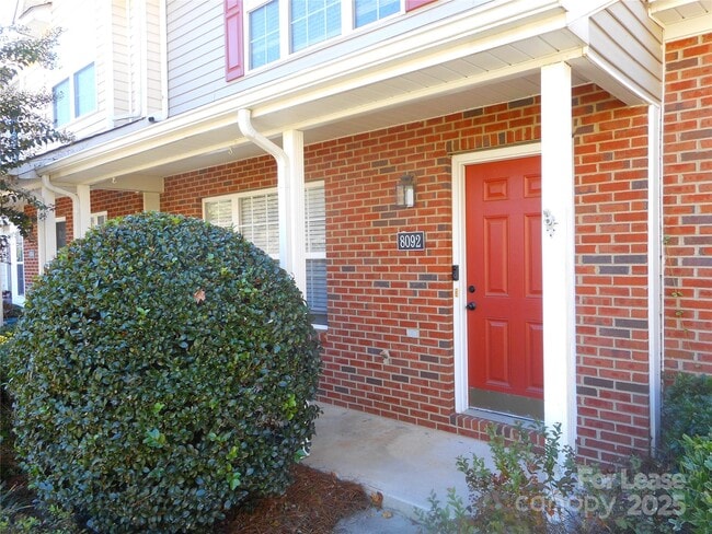
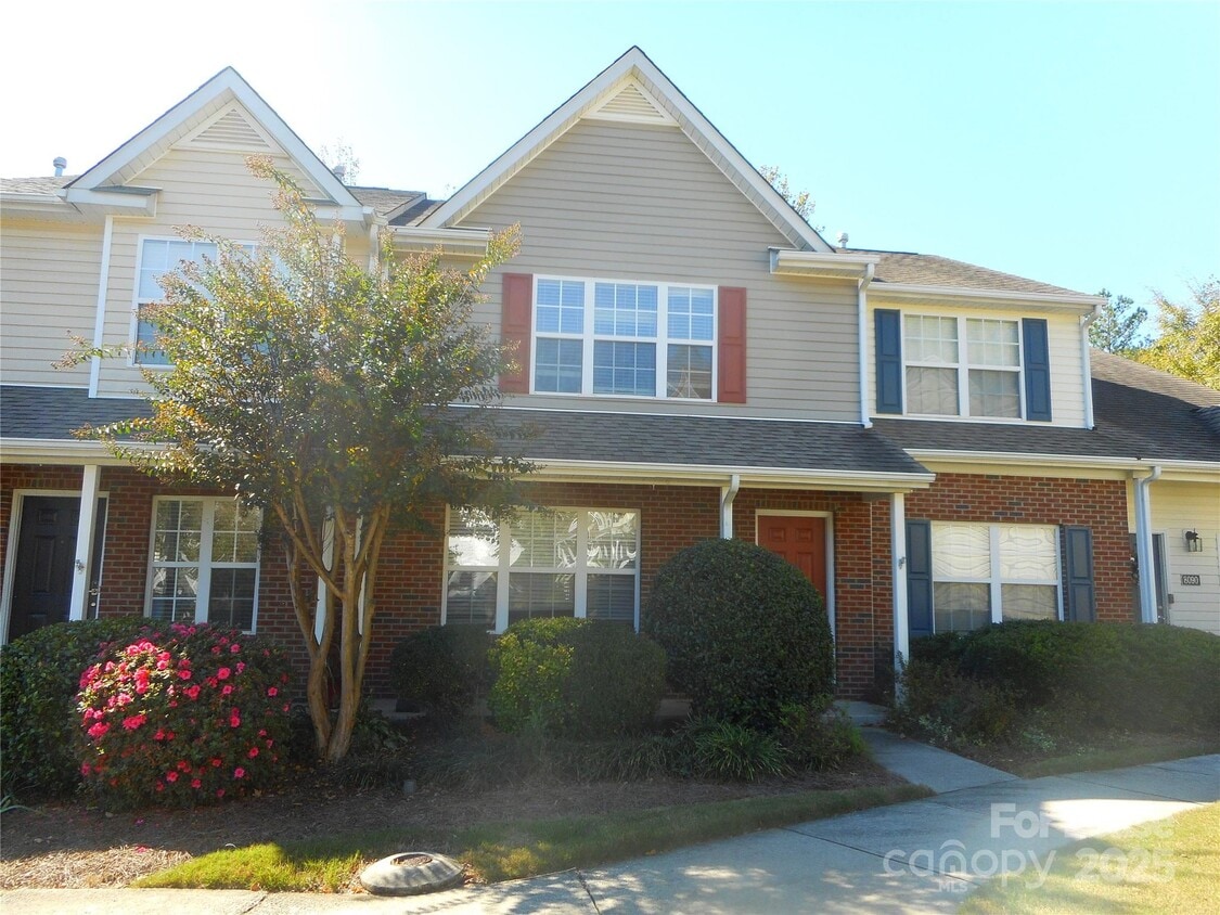
8092 Kennet Ln
Indian Land, SC 29707
Today
Favorites
704-900-5005
-
Bedrooms
2
-
Bathrooms
2.5
-
Square Feet
1,344 sq ft
-
Available
Available Now
Highlights
- Open Floorplan
- Contemporary Architecture
- Furnished
- Lawn
- Community Pool
- Covered Patio or Porch
8092 Kennet Ln

Favorites
About This Home
$1,695 deposit,
Available Now
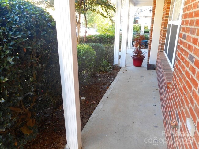
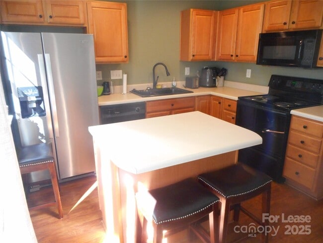
Furnished townhome in Indian Land with 2 bedrooms and 2.5 baths. Terrific front covered porch. Nice furnishings including living room,dining area,bedroom sets and washer and dryer included. Storage closet on back patio with private setting. Park right out front of this unit with numbered parking. Close to lots of shopping and restaurants - attached to great schools and minures to Ballantyne and 485. Furnished townhome.
8092 Kennet Ln is a townhome located in Lancaster County and the 29707 ZIP Code. This area is served by the Lancaster 01 attendance zone.
* Price shown is base rent. Excludes user-selected optional fees and variable or usage-based fees and required charges due at or prior to move-in or at move-out. Price, availability, fees, and any applicable rent special are subject to change without notice.
* Square footage definitions vary. Displayed square footage is approximate.
Home Details
Year Built
Built in 2004
Bedrooms and Bathrooms
Walk-In Closet
2 Bedrooms
2.5 Bathrooms
Flooring
Carpet
Laminate
Vinyl
Home Design
Contemporary Architecture
Composition Roof
Slab Foundation
Entry on the 1st floor
Home Security
Carbon Monoxide Detectors
Interior Spaces
Open Floorplan
Furnished
1,344 Sq Ft Home
2-Story Property
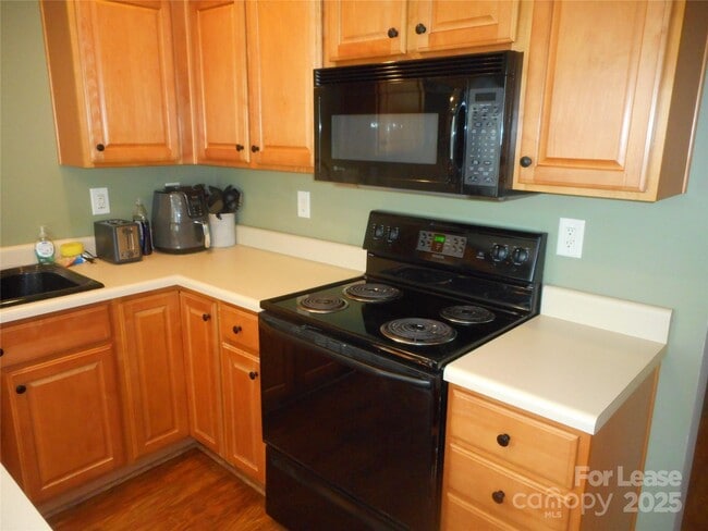
Kitchen
Electric Range
Electric Oven
Microwave
Dishwasher
Self-Cleaning Oven
Disposal
Laundry
Laundry Room
Washer and Dryer
Listing and Financial Details
Security Deposit $1,695
Property Available on 10/23/25
Assessor Parcel Number 0010B-20-005.00
Tenant pays for all utilities
Lot Details
Lawn
Cul-De-Sac
Level Lot
Property is zoned HDR
Outdoor Features
Covered Patio or Porch
Parking
Assigned Parking
Schools
Indian Land Elementary And Middle School
Indian Land High School
Utilities
Forced Air Heating and Cooling System
Gas Water Heater
Cable TV Available
Community Details
Overview
Property has a Home Owners Association
Windsor Trace Condos
Windsor Trace Subdivision
Pet Policy
Pet Deposit $250
Recreation
Community Pool
Contact
- Listed by Jim Acord | Carolina United Realty LLC
- Phone Number
- Contact
-
Source
Canopy MLS
Copyright © 2025 Canopy Realtor® Association.
Location
Get Directions
Located halfway between Rock Hill and Charlotte, North Carolina, Indian Land is a primarily residential community named for its history as the home of the Catawba and Waxhaw tribes. Numerous commercial offerings line U.S. 521, including chain restaurants and local eateries.
Golfing opportunities abound in the surrounding areas, with the Fort Mill Golf Club, Cedarwood Country Club, and Carmel Country Club all located within close proximity. Indian Land offers residents the peace and quiet they deserve within a 30-minute drive of bustling Charlotte.
Learn more about living in Indian Land
Education
| Colleges & Universities | Distance | ||
|---|---|---|---|
| Colleges & Universities | Distance | ||
| Drive: | 23 min | 13.0 mi | |
| Drive: | 24 min | 14.1 mi | |
| Drive: | 27 min | 17.3 mi | |
| Drive: | 35 min | 18.9 mi |
8092 Kennet Ln is within 23 minutes or 13.0 miles from Central Piedmont C.C., Harper. It is also near Winthrop University and Central Piedmont C.C., Levine.
Schools


Public Elementary School
Grades K-5
1,035 Students
Attendance Zone
Public Middle School
Grades 6-8
989 Students
Attendance Zone
Public High School
Grades 9-12
1,678 Students
Attendance Zone
Private Elementary, Middle & High School
Grades PK-12
184 Students
Nearby
Private Elementary & Middle School
Grades K-8
127 Students
Nearby
Private Elementary & Middle School
Grades PK-9
178 Students
Nearby
Private Elementary School
Grades K
11 Students
Nearby
School data provided by
 The GreatSchools Rating helps parents compare schools within a state based on a variety of school quality indicators and provides a helpful picture of how effectively each school serves all of its students. Ratings are on a scale of 1 (below average) to 10 (above average) and can include test scores, college readiness, academic progress, advanced courses, equity, discipline and attendance data. We also advise parents to visit schools, consider other information on school performance and programs, and consider family needs as part of the school selection process.
View GreatSchools Rating Methodology
Data provided by GreatSchools.org © 2025. All rights reserved.
View GreatSchools Rating Methodology
Data provided by GreatSchools.org © 2025. All rights reserved.
Transportation options available in Indian Land include I-485/South Boulevard, located 10.7 miles from 8092 Kennet Ln. 8092 Kennet Ln is near Charlotte/Douglas International, located 20.0 miles or 34 minutes away, and Concord-Padgett Regional, located 41.3 miles or 53 minutes away.
| Transit / Subway | Distance | ||
|---|---|---|---|
| Transit / Subway | Distance | ||
|
|
Drive: | 18 min | 10.7 mi |
|
|
Drive: | 20 min | 11.5 mi |
| Commuter Rail | Distance | ||
|---|---|---|---|
| Commuter Rail | Distance | ||
|
|
Drive: | 37 min | 23.6 mi |
|
|
Drive: | 48 min | 34.9 mi |
| Airports | Distance | ||
|---|---|---|---|
| Airports | Distance | ||
|
Charlotte/Douglas International
|
Drive: | 34 min | 20.0 mi |
|
Concord-Padgett Regional
|
Drive: | 53 min | 41.3 mi |
Time and distance from 8092 Kennet Ln.
| Shopping Centers | Distance | ||
|---|---|---|---|
| Shopping Centers | Distance | ||
| Drive: | 4 min | 1.5 mi | |
| Drive: | 4 min | 1.7 mi | |
| Drive: | 5 min | 1.7 mi |
8092 Kennet Ln has 3 shopping centers within 1.7 miles, which is about a 5-minute drive. The miles and minutes will be for the farthest away property.
| Parks and Recreation | Distance | ||
|---|---|---|---|
| Parks and Recreation | Distance | ||
|
Marvin Efird Park
|
Drive: | 12 min | 5.5 mi |
|
Stream Park
|
Drive: | 11 min | 5.9 mi |
|
Brixham Park
|
Drive: | 12 min | 6.3 mi |
|
Ballantyne's Backyard
|
Drive: | 14 min | 7.2 mi |
8092 Kennet Ln has 4 parks within 7.2 miles, including Marvin Efird Park, Stream Park, and Brixham Park.
| Hospitals | Distance | ||
|---|---|---|---|
| Hospitals | Distance | ||
| Drive: | 17 min | 9.5 mi | |
| Drive: | 15 min | 10.0 mi | |
| Drive: | 20 min | 11.8 mi |
8092 Kennet Ln has 3 hospitals within 11.8 miles, the nearest is Carolinas Medical Center - Pineville which is 9.5 miles away and a 17 minute drive.
| Military Bases | Distance | ||
|---|---|---|---|
| Military Bases | Distance | ||
| Drive: | 121 min | 87.1 mi |
8092 Kennet Ln is 87.1 miles and a 121 minute drive from Fort Jackson.
You May Also Like
Similar Rentals Nearby


What Are Walk Score®, Transit Score®, and Bike Score® Ratings?
Walk Score® measures the walkability of any address. Transit Score® measures access to public transit. Bike Score® measures the bikeability of any address.
What is a Sound Score Rating?
A Sound Score Rating aggregates noise caused by vehicle traffic, airplane traffic and local sources
8092 Kennet Ln
Indian Land, SC 29707