

$6,500 / Month
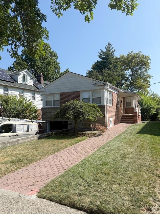
80-43 Utopia Pkwy
Queens, NY 11432
Today
Favorites
718-380-2500
-
Bedrooms
5
-
Bathrooms
3
-
Square Feet
1,375 sq ft
-
Available
Available Now
80-43 Utopia Pkwy

Favorites
About This Home
Available Now
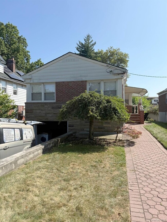
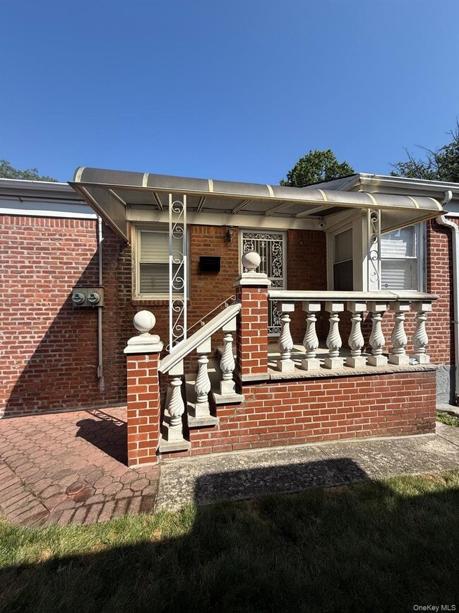
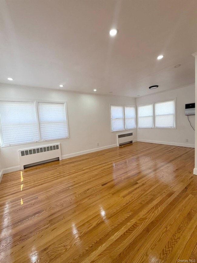
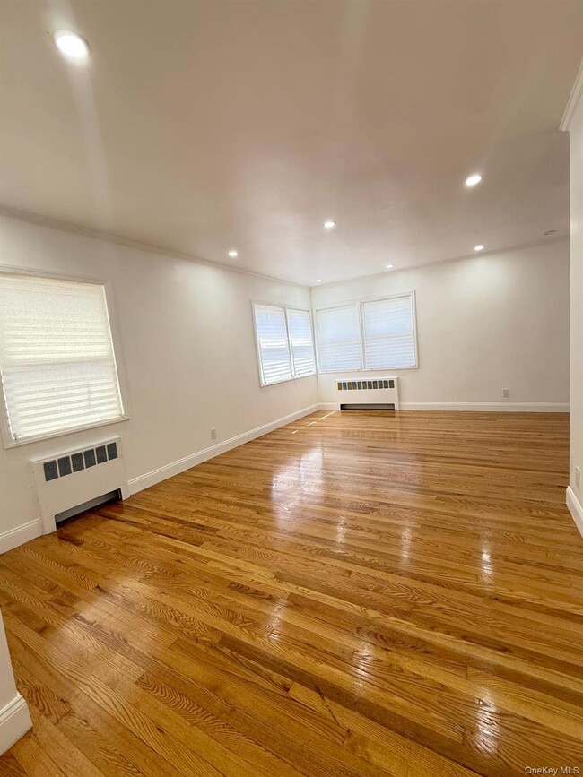
Fully renovated detached house located in the heart of Jamaica Estates. The house features a private foyer,spacious living room,formal dining are,kitchen with new appliances,totaling 5-bedrooms,3-full bathrooms,above ground full finished basement with high ceilings and a separate entrance. The house has a 1 car garage,plenty of closet spaces and a private backyard. The house is conveniently located close to all major shopping,parks,schools and houses of worship. Based on information submitted to the MLS GRID as of [see last changed date above]. All data is obtained from various sources and may not have been verified by broker or MLS GRID. Supplied Open House Information is subject to change without notice. All information should be independently reviewed and verified for accuracy. Properties may or may not be listed by the office/agent presenting the information. Some IDX listings have been excluded from this website. Prices displayed on all Sold listings are the Last Known Listing Price and may not be the actual selling price.
80-43 Utopia Pkwy is a house located in Queens County and the 11432 ZIP Code. This area is served by the New York City Geographic District #26 attendance zone.
* Price shown is base rent and may not include non-optional fees and utilities.
Price, availability, fees, and any applicable rent special are subject to change without notice.
* Square footage definitions vary. Displayed square footage is approximate.
Contact
- Listed by Solomon Davydov | Exit Realty First Choice
- Phone Number
- Contact
-
Source
 OneKey® MLS
Information Copyright 2025, OneKey® MLS. All Rights Reserved.
The source of the displayed data is either the property owner or public record provided by non-governmental third parties. It is believed to be reliable but not guaranteed. This information is provided exclusively for consumers’ personal, non-commercial use.
The data relating to real estate for sale on this website comes in part from the IDX Program of OneKey® MLS.
Location
Get Directions
In the center of Queens, you’ll come upon one of the most tree-filled neighborhoods in New York City, a unique quality for an urban area. Originally created to be a luxurious, suburban escape from Manhattan, Jamaica Estates houses historic mansions, including Donald Trump’s childhood home, and exudes a park-like atmosphere.
This historic neighborhood boasts a family-friendly environment with a variety of apartments and houses for rent. Nearby subway and bus stations make traveling in and out of Jamaica Estates a breeze, along with easy access to major roads like Grand Central Parkway and Hillside Avenue. Travel along Hillside Avenue on the south end of town for banks, restaurants, supermarkets, and more conveniences.
Jamaica Estates borders the expansive Cunningham Park on its east and Saint John’s University Queens Campus on its west.
Learn more about living in Jamaica Estates
Education
| Colleges & Universities | Distance | ||
|---|---|---|---|
| Colleges & Universities | Distance | ||
| Walk: | 8 min | 0.4 mi | |
| Drive: | 6 min | 2.2 mi | |
| Drive: | 7 min | 3.5 mi | |
| Drive: | 7 min | 3.6 mi |
80-43 Utopia Pkwy is within 8 minutes or 0.4 mile from St. John's University. It is also near York College and Queens College.
Schools


Public Elementary & Middle School
Grades PK-8
513 Students
Nearby
Public Elementary School
Grades PK-5
929 Students
Nearby
Public Elementary School
Grades PK-5
657 Students
Attendance Zone
Public Middle & High School
Grades 6-12
643 Students
Nearby
Private Elementary, Middle & High School
Grades PK-12
Nearby
Private Elementary & Middle School
Grades PK-8
199 Students
Nearby
School data provided by
 The GreatSchools Rating helps parents compare schools within a state based on a variety of school quality indicators and provides a helpful picture of how effectively each school serves all of its students. Ratings are on a scale of 1 (below average) to 10 (above average) and can include test scores, college readiness, academic progress, advanced courses, equity, discipline and attendance data. We also advise parents to visit schools, consider other information on school performance and programs, and consider family needs as part of the school selection process.
View GreatSchools Rating Methodology
Data provided by GreatSchools.org © 2025. All rights reserved.
View GreatSchools Rating Methodology
Data provided by GreatSchools.org © 2025. All rights reserved.
Transportation options available in Queens include 169 Street, located 1.0 miles from 80-43 Utopia Pkwy. 80-43 Utopia Pkwy is near LaGuardia, located 7.1 miles or 13 minutes away, and John F Kennedy International, located 8.3 miles or 12 minutes away.
| Transit / Subway | Distance | ||
|---|---|---|---|
| Transit / Subway | Distance | ||
|
|
Walk: | 19 min | 1.0 mi |
|
|
Drive: | 3 min | 1.1 mi |
|
|
Drive: | 4 min | 1.9 mi |
|
|
Drive: | 5 min | 2.3 mi |
|
|
Drive: | 5 min | 2.3 mi |
| Commuter Rail | Distance | ||
|---|---|---|---|
| Commuter Rail | Distance | ||
|
|
Drive: | 6 min | 1.8 mi |
|
|
Drive: | 6 min | 2.4 mi |
|
|
Drive: | 6 min | 2.7 mi |
|
|
Drive: | 6 min | 2.7 mi |
|
|
Drive: | 7 min | 2.9 mi |
| Airports | Distance | ||
|---|---|---|---|
| Airports | Distance | ||
|
LaGuardia
|
Drive: | 13 min | 7.1 mi |
|
John F Kennedy International
|
Drive: | 12 min | 8.3 mi |
Time and distance from 80-43 Utopia Pkwy.
| Shopping Centers | Distance | ||
|---|---|---|---|
| Shopping Centers | Distance | ||
| Walk: | 1 min | 0.1 mi | |
| Walk: | 19 min | 1.0 mi | |
| Drive: | 5 min | 1.6 mi |
80-43 Utopia Pkwy has 3 shopping centers within 1.6 miles, which is about a 5-minute walk. The miles and minutes will be for the farthest away property.
| Parks and Recreation | Distance | ||
|---|---|---|---|
| Parks and Recreation | Distance | ||
|
Cunningham Park
|
Drive: | 3 min | 1.8 mi |
|
Detective Keith L. Williams Park
|
Drive: | 7 min | 2.3 mi |
|
Rufus King Park
|
Drive: | 6 min | 2.4 mi |
|
Kissena Park
|
Drive: | 6 min | 2.4 mi |
|
Queens Botanical Garden
|
Drive: | 7 min | 4.2 mi |
80-43 Utopia Pkwy has 5 parks within 4.2 miles, including Cunningham Park, Detective Keith L. Williams Park, and Rufus King Park.
| Hospitals | Distance | ||
|---|---|---|---|
| Hospitals | Distance | ||
| Drive: | 2 min | 1.2 mi | |
| Drive: | 5 min | 2.8 mi | |
| Drive: | 7 min | 3.3 mi |
80-43 Utopia Pkwy has 3 hospitals within 3.3 miles, the nearest is Queens Hospital Center which is 1.2 miles away and a 2 minute drive.
| Military Bases | Distance | ||
|---|---|---|---|
| Military Bases | Distance | ||
| Drive: | 10 min | 6.6 mi | |
| Drive: | 34 min | 17.1 mi |
80-43 Utopia Pkwy is 6.6 miles from Fort Totten US Govt Reservation, and is convenient to other military bases, including US Coast Guard Heliport.
You May Also Like
Similar Rentals Nearby


What Are Walk Score®, Transit Score®, and Bike Score® Ratings?
Walk Score® measures the walkability of any address. Transit Score® measures access to public transit. Bike Score® measures the bikeability of any address.
What is a Sound Score Rating?
A Sound Score Rating aggregates noise caused by vehicle traffic, airplane traffic and local sources
80-43 Utopia Pkwy
Queens, NY 11432