
$7,500
Total Monthly Price
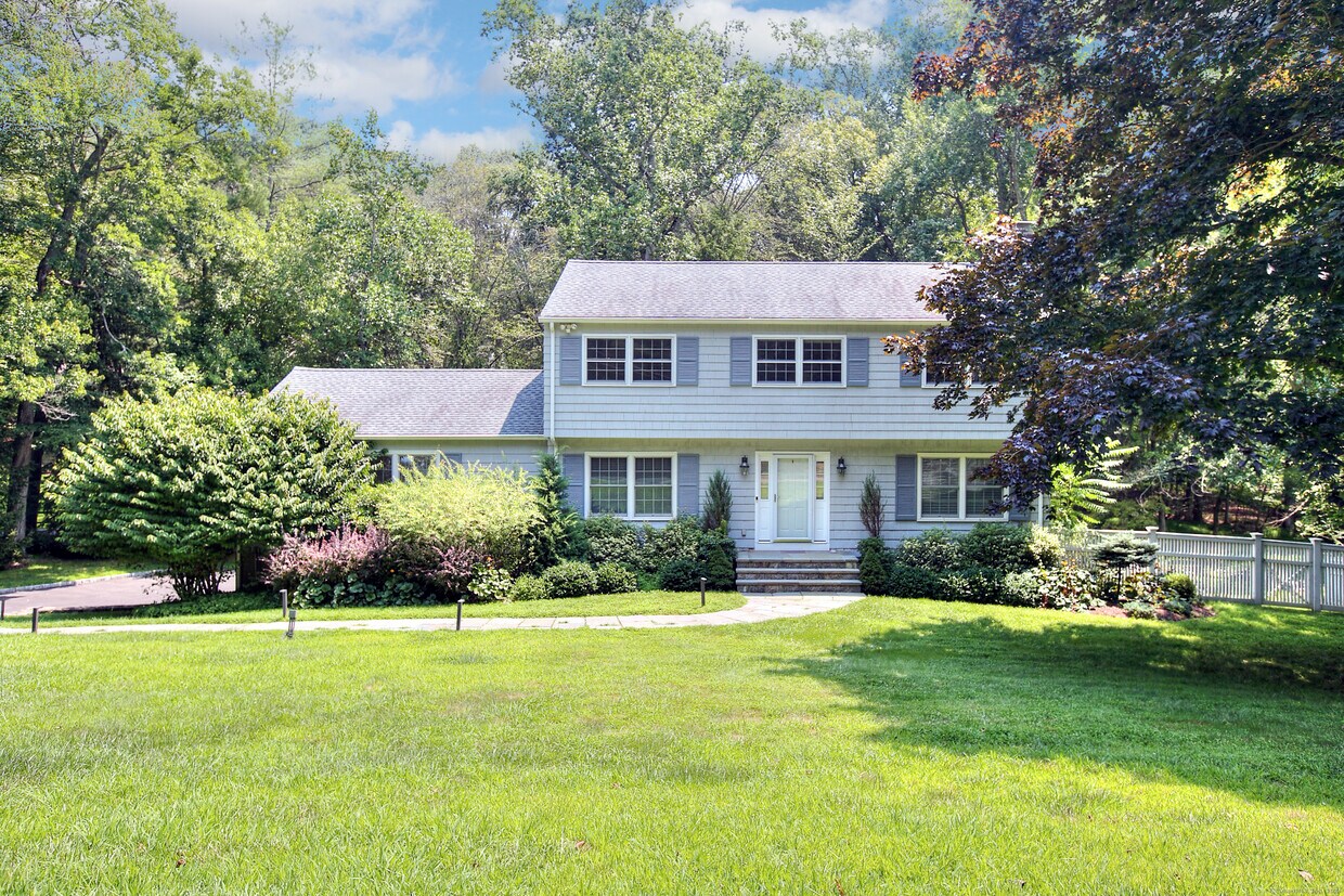
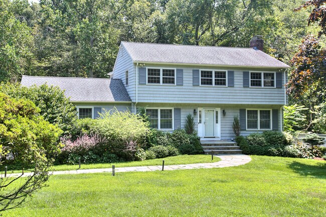
8 Clover Ln
Westport, CT 06880
Favorites
8 Clover Ln

Favorites
Check Back Soon for Upcoming Availability
| Beds | Baths | Average SF |
|---|---|---|
| 4 Bedrooms 4 Bedrooms 4 Br | 2.5 Baths 2.5 Baths 2.5 Ba | — |
Fees and Policies
The fees listed below are community-provided and may exclude utilities or add-ons. All payments are made directly to the property and are non-refundable unless otherwise specified.
- Dogs Allowed
-
Fees not specified
- Cats Allowed
-
Fees not specified
About This Property
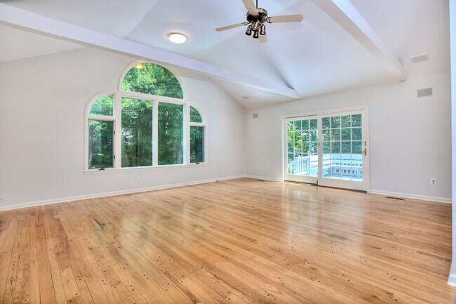
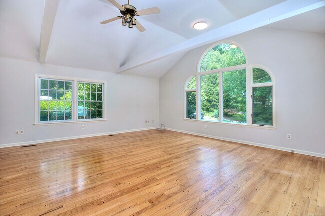
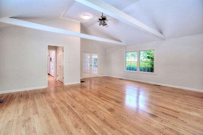
Check out this home, on a quiet/private cul-de-sac yet convenient to all amenities. Finished on all 3 levels with over 3000 square ft including the finished bright walkout lower level creates ideal space for an office, gym or a fifth bedroom! The large eat in kitchen has Dacor, Subzero and Bosch appliances, a grand island, and plenty of storage. From the kitchen is an inviting living room with a fireplace, family room with vaulted ceilings, and a spacious formal dining room. Sliders off the kitchen family/room onto the deck make for easy entertaining. The primary suite has a bath with steam and a good size walk in closet. Three additional bedrooms on the second level display great light and space. This is a pristine home with a generator.
8 Clover Ln is a house located in Fairfield County and the 06880 ZIP Code. This area is served by the Westport School District attendance zone.
8 Clover Ln,
Westport,
CT
06880
Situated about 50 miles northeast of New York City, Westport is equal parts upscale suburb and old New England town. Westport maintains its historic charm as it continues to modernize with premier shops, fitness boutiques, delectable eateries, and cultural amenities.
Westport residents enjoy access to a bevy of performances at the Levitt Pavilion for the Performing Arts and the Westport Country Playhouse. Earthplace uncovers natural history with extensive wildlife exhibits.
Recreational opportunities abound in Westport, at Sherwood Island State Park, Compo Beach, and Westport Longshore Club Park. Popular activities in Westport include boating, swimming, fishing, hiking, and more.
Families flock to Westport for its top-notch schools, quick commute to New York City, and charming atmosphere along the Long Island Sound. Getting around from Westport is easy with access to the I-95, U.S. 1, and public transit.
Learn more about living in Westport
Education
| Colleges & Universities | Distance | ||
|---|---|---|---|
| Colleges & Universities | Distance | ||
| Drive: | 17 min | 7.9 mi | |
| Drive: | 17 min | 9.2 mi | |
| Drive: | 20 min | 11.0 mi | |
| Drive: | 25 min | 15.6 mi |
8 Clover Ln is within 17 minutes or 7.9 miles from Fairfield University. It is also near Sacred Heart University and University of Bridgeport.
Schools


Public Elementary School
Grades K-5
245 Students
Nearby
Public Elementary School
Grades K-5
590 Students
Attendance Zone
Public Middle School
Grades 6-8
729 Students
Attendance Zone
Public High School
Grades 9-12
1,686 Students
Attendance Zone
Private Elementary & Middle School
Grades K-8
201 Students
Nearby
Private Elementary, Middle & High School
Grades K-12
138 Students
Nearby
Private Middle & High School
Grades 6-12
14 Students
Nearby
School data provided by
 The GreatSchools Rating helps parents compare schools within a state based on a variety of school quality indicators and provides a helpful picture of how effectively each school serves all of its students. Ratings are on a scale of 1 (below average) to 10 (above average) and can include test scores, college readiness, academic progress, advanced courses, equity, discipline and attendance data. We also advise parents to visit schools, consider other information on school performance and programs, and consider family needs as part of the school selection process.
View GreatSchools Rating Methodology
Data provided by GreatSchools.org © 2026. All rights reserved.
View GreatSchools Rating Methodology
Data provided by GreatSchools.org © 2026. All rights reserved.
Walkability Near 8 Clover Ln Westport, CT 06880
Getting Around
 What do Walkability, Transit, Drivability, and Bikeability mean?
Walkability measures the walking distance to day-to-day needs.
Transit measures access to public transportation.
Drivability measures congestion, parking availability, and access to major roads.
Bikeability measures the suitability for cycling.
How It Works
What do Walkability, Transit, Drivability, and Bikeability mean?
Walkability measures the walking distance to day-to-day needs.
Transit measures access to public transportation.
Drivability measures congestion, parking availability, and access to major roads.
Bikeability measures the suitability for cycling.
How It Works
Somewhat Walkable
Walkability
30
/ 100
Minimal Public Transit
Transit
0
/ 100
Very Drivable
Drivability
80
/ 100
Fairly Bikeable
Bikeability
40
/ 100
Scores provided by
-
Soundscore™
-
/ 100
Traffic
-Airport
-Businesses
-Scores provided by
HowLoud What is a Sound Score Rating? A Sound Score Rating aggregates noise caused by vehicle traffic, airplane traffic and local sources. How It WorksYou May Also Like
Similar Rentals Nearby
-
-

-

-

-

-

-
 5 Beds, 4 Baths, 3,615 sq ft$12,500Total Monthly PriceTotal Monthly Price NewPrices include all required monthly fees.71 High Point Rd
 -
 5 Beds, 5 Baths, 3,900 sq ft$12,000Total Monthly PriceTotal Monthly Price NewPrices include all required monthly fees.38 Sturges Cmns
 -
 4 Beds, 3 Baths, 2,803 sq ft$7,300Total Monthly PriceTotal Monthly Price NewPrices include all required monthly fees.332 Belden Hill Rd
 -
 4 Beds, 2 Baths, 1,450 sq ft$4,200Total Monthly PriceTotal Monthly Price NewPrices include all required monthly fees.11 Colony St
What Are Walk Score®, Transit Score®, and Bike Score® Ratings?
Walk Score® measures the walkability of any address. Transit Score® measures access to public transit. Bike Score® measures the bikeability of any address.
What is a Sound Score Rating?
A Sound Score Rating aggregates noise caused by vehicle traffic, airplane traffic and local sources.

8 Clover Ln
Westport, CT 06880