
Williamsburg
200 W Galbraith Rd,
Cincinnati, OH 45215
$843 - $2,791
Studio - 3 Beds


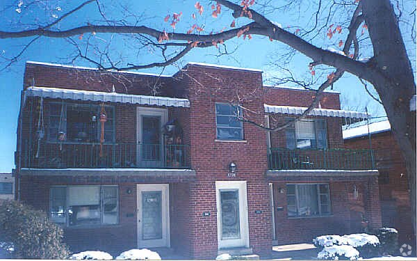
Discover 7700-7714 Cheviot Rd. Based in the 45247 Zip code of Cincinnati on Cheviot Rd., residents have a quick connection to a number of enjoyable entertainment options within a few miles. The professional leasing staff is waiting to show you all that this community has in store. Be sure to come for a visit to see the current floorplan options. Contact us or stop by today.
7700-7714 Cheviot Rd is an apartment community located in Hamilton County and the 45247 ZIP Code. This area is served by the Northwest Local School District attendance zone.
Cincinnati sits on the northern bank of the Ohio River, where rolling hills meet a city that helped establish the Midwest long before other major metros existed. Settled in 1788, the Queen City sits west of the Appalachian Mountains and combines historic culture with urban living.
Today, neighborhoods like Over-the-Rhine, Hyde Park, and Mount Adams each bring a distinct character to city life. Over-the-Rhine is packed with restored 19th-century architecture, Findlay Market, and Music Hall. Mount Adams perches beside Eden Park with stunning river views, while Hyde Park Square draws locals and tourists alike with local cafes and walkable streets.
Renters will find a wide range of housing options across the city, from converted lofts and townhouses in Over-the-Rhine to sleek high-rise apartment communities along the riverfront at The Banks. Clifton and Oakley offer everything from charming older buildings to newer developments with modern amenities.
Learn more about living in CincinnatiCompare neighborhood and city base rent averages by bedroom.
| Northwest Cincinnati | Cincinnati, OH | |
|---|---|---|
| Studio | $702 | $1,073 |
| 1 Bedroom | $942 | $1,135 |
| 2 Bedrooms | $1,139 | $1,424 |
| 3 Bedrooms | $1,445 | $1,731 |
| Colleges & Universities | Distance | ||
|---|---|---|---|
| Colleges & Universities | Distance | ||
| Drive: | 17 min | 8.5 mi | |
| Drive: | 17 min | 9.9 mi | |
| Drive: | 19 min | 10.3 mi | |
| Drive: | 22 min | 13.3 mi |


Transportation options available in Cincinnati include Brewery District Station - Elm & Henry, located 10.6 miles from 7700-7714 Cheviot Rd. 7700-7714 Cheviot Rd is near Cincinnati/Northern Kentucky International, located 24.6 miles or 42 minutes away.
| Transit / Subway | Distance | ||
|---|---|---|---|
| Transit / Subway | Distance | ||
| Drive: | 18 min | 10.6 mi | |
| Drive: | 18 min | 10.7 mi | |
| Drive: | 18 min | 10.8 mi | |
| Drive: | 19 min | 10.8 mi | |
| Drive: | 19 min | 10.9 mi |
| Commuter Rail | Distance | ||
|---|---|---|---|
| Commuter Rail | Distance | ||
|
|
Drive: | 18 min | 10.6 mi |
| Airports | Distance | ||
|---|---|---|---|
| Airports | Distance | ||
|
Cincinnati/Northern Kentucky International
|
Drive: | 42 min | 24.6 mi |
Scores provided by
Traffic
ActiveAirport
CalmBusinesses
CalmScores provided by
HowLoud What is a Sound Score Rating? A Sound Score Rating aggregates noise caused by vehicle traffic, airplane traffic and local sources. How It WorksTime and distance from 7700-7714 Cheviot Rd.
| Shopping Centers | Distance | ||
|---|---|---|---|
| Shopping Centers | Distance | ||
| Walk: | 19 min | 1.0 mi | |
| Drive: | 2 min | 1.1 mi | |
| Drive: | 2 min | 1.2 mi |
| Parks and Recreation | Distance | ||
|---|---|---|---|
| Parks and Recreation | Distance | ||
|
Farbach-Werner Nature Preserve
|
Drive: | 4 min | 1.6 mi |
|
Mt. Airy Forest
|
Drive: | 9 min | 3.9 mi |
|
LaBoiteaux Woods
|
Drive: | 9 min | 4.1 mi |
|
Buttercup Valley
|
Drive: | 12 min | 5.1 mi |
|
Triple Creek Park
|
Drive: | 14 min | 5.8 mi |
| Hospitals | Distance | ||
|---|---|---|---|
| Hospitals | Distance | ||
| Drive: | 7 min | 3.1 mi | |
| Drive: | 16 min | 9.1 mi | |
| Drive: | 13 min | 9.3 mi |
| Military Bases | Distance | ||
|---|---|---|---|
| Military Bases | Distance | ||
| Drive: | 69 min | 53.1 mi | |
| Drive: | 75 min | 58.1 mi | |
| Drive: | 77 min | 61.4 mi |
Pets Allowed Pool In Unit Washer & Dryer Clubhouse Maintenance on site Stainless Steel Appliances
What Are Walk Score®, Transit Score®, and Bike Score® Ratings?
Walk Score® measures the walkability of any address. Transit Score® measures access to public transit. Bike Score® measures the bikeability of any address.
What is a Sound Score Rating?
A Sound Score Rating aggregates noise caused by vehicle traffic, airplane traffic and local sources.
7700-7714 Cheviot Rd
Cincinnati, OH 45247


