

$15,000
/ Month
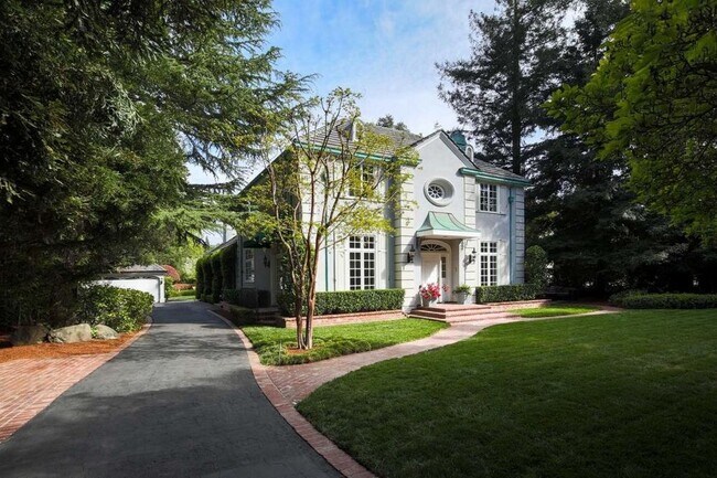
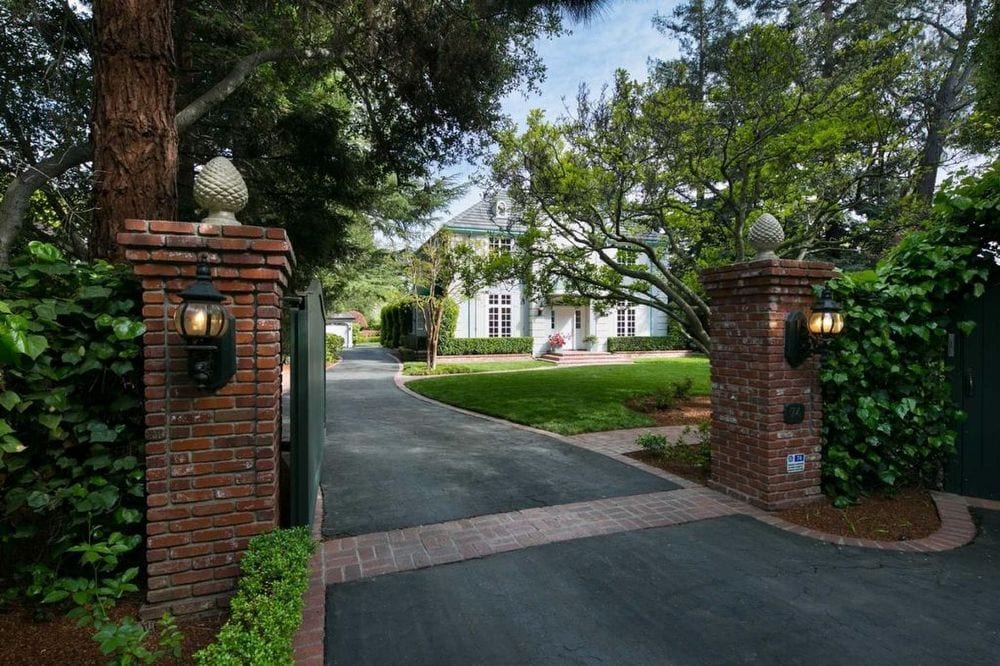
74 Holbrook Ln
Atherton, CA 94027
2 Weeks Ago
|
Edit
Favorites
74 Holbrook Ln

Favorites
Check Back Soon for Upcoming Availability
| Beds | Baths | Average SF |
|---|---|---|
| 5 Bedrooms 5 Bedrooms 5 Br | 3.5 Baths 3.5 Baths 3.5 Ba | 3,685 SF |
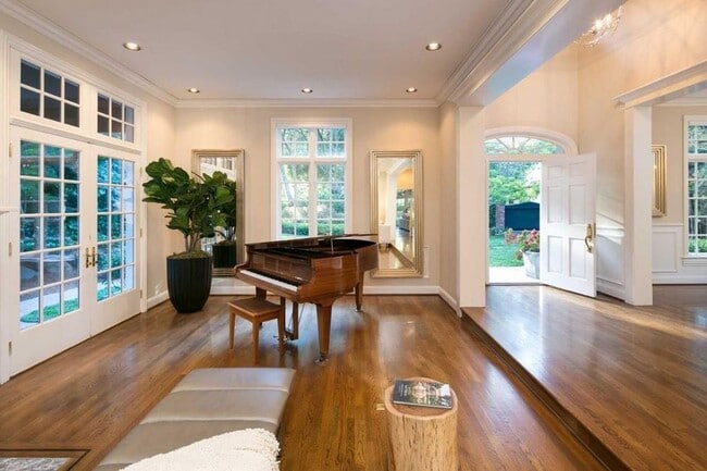
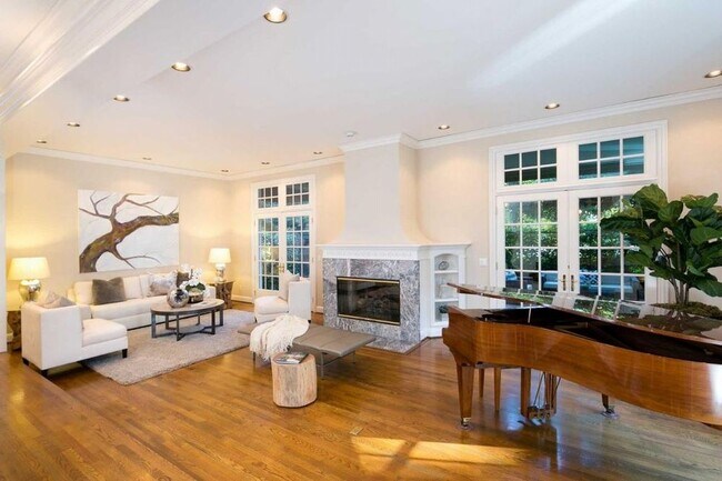
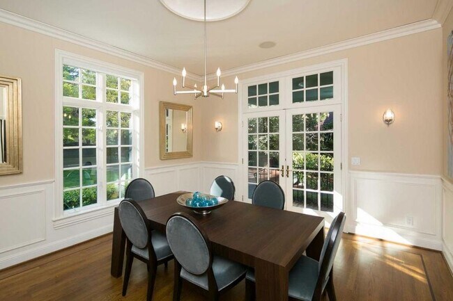
About This Property
Exquisite Executive Home in the Heart of the Silicon Valley. Spacious Sunlit Living Family Dinning Areas. High-end Finishes throughout. A Huge Yard and Pool for Outdoor Entertaining. Call Today All Utilities Renters Liability Insurance Application/Credit Report Fee
74 Holbrook Ln is a house located in San Mateo County and the 94027 ZIP Code. This area is served by the Menlo Park City Elementary School District attendance zone.
House Features
- Disposal
- Microwave
- Refrigerator
74 Holbrook Ln,
Atherton,
CA
94027
The Fair Oaks neighborhood provides a pleasant mix of residential homes and apartments for rent and features several commercial enterprises. Inside the neighborhood, bus stops dot the streets, making it easy to get downtown or to local hotspots. Atherton Station offers train service to other parts of California for residents who want to get away for a weekend.
In the mornings, locals stop by the Donut Depot for their morning fix of donuts and donut holes. When locals want something with a kick, they head to Taqueria Apatzingan for authentic Mexican food. Chile Colorado, chicken enchiladas, and nachos are just a few of the popular dishes that fly out of the kitchen.
Learn more about living in Fair OaksBelow are rent ranges for similar nearby apartments
Amenities
- Disposal
- Microwave
- Refrigerator
Education
| Colleges & Universities | Distance | ||
|---|---|---|---|
| Colleges & Universities | Distance | ||
| Drive: | 4 min | 1.5 mi | |
| Drive: | 13 min | 5.0 mi | |
| Drive: | 16 min | 6.0 mi | |
| Drive: | 13 min | 8.1 mi |
74 Holbrook Ln is within 4 minutes or 1.5 miles from Menlo College. It is also near Stanford University and Canada College.
Schools


Public Elementary School
Grades K-5
Nearby
Public Elementary School
Grades K-5
Attendance Zone
Public Middle School
Grades 6-8
Attendance Zone
Public High School
Grades 9-12
Attendance Zone
Private Elementary & Middle School
Grades PK-8
Nearby
Private Elementary, Middle & High School
Grades K-12
Nearby
Private Elementary & Middle School
Grades K-8
Nearby
School data provided by
 The GreatSchools Rating helps parents compare schools within a state based on a variety of school quality indicators and provides a helpful picture of how effectively each school serves all of its students. Ratings are on a scale of 1 (below average) to 10 (above average) and can include test scores, college readiness, academic progress, advanced courses, equity, discipline and attendance data. We also advise parents to visit schools, consider other information on school performance and programs, and consider family needs as part of the school selection process.
View GreatSchools Rating Methodology
Data provided by GreatSchools.org © 2026. All rights reserved.
View GreatSchools Rating Methodology
Data provided by GreatSchools.org © 2026. All rights reserved.
Transportation options available in Atherton include Bayshore Nasa Station, located 10.4 miles from 74 Holbrook Ln. 74 Holbrook Ln is near San Francisco International, located 17.5 miles or 24 minutes away, and Norman Y Mineta San Jose International, located 18.0 miles or 24 minutes away.
| Transit / Subway | Distance | ||
|---|---|---|---|
| Transit / Subway | Distance | ||
| Drive: | 14 min | 10.4 mi | |
| Drive: | 15 min | 10.8 mi | |
|
|
Drive: | 16 min | 11.0 mi |
|
|
Drive: | 16 min | 11.0 mi |
| Drive: | 16 min | 11.3 mi |
| Commuter Rail | Distance | ||
|---|---|---|---|
| Commuter Rail | Distance | ||
| Drive: | 5 min | 1.7 mi | |
| Drive: | 7 min | 2.7 mi | |
| Drive: | 8 min | 3.1 mi | |
| Drive: | 12 min | 4.9 mi | |
| Drive: | 11 min | 6.9 mi |
| Airports | Distance | ||
|---|---|---|---|
| Airports | Distance | ||
|
San Francisco International
|
Drive: | 24 min | 17.5 mi |
|
Norman Y Mineta San Jose International
|
Drive: | 24 min | 18.0 mi |
Walkability Near 74 Holbrook Ln Atherton, CA 94027
Getting Around
 What do Walkability, Transit, Drivability, and Bikeability mean?
Walkability measures the walking distance to day-to-day needs.
Transit measures access to public transportation.
Drivability measures congestion, parking availability, and access to major roads.
Bikeability measures the suitability for cycling.
How It Works
What do Walkability, Transit, Drivability, and Bikeability mean?
Walkability measures the walking distance to day-to-day needs.
Transit measures access to public transportation.
Drivability measures congestion, parking availability, and access to major roads.
Bikeability measures the suitability for cycling.
How It Works
Moderately Walkable
Walkability
60
/ 100
Limited Public Transit
Transit
30
/ 100
Exceptionally Drivable
Drivability
90
/ 100
Moderately Bikeable
Bikeability
60
/ 100
Scores provided by
-
Soundscore™
-
/ 100
Traffic
-Airport
-Businesses
-Scores provided by
HowLoud What is a Sound Score Rating? A Sound Score Rating aggregates noise caused by vehicle traffic, airplane traffic and local sources. How It WorksTime and distance from 74 Holbrook Ln.
| Shopping Centers | Distance | ||
|---|---|---|---|
| Shopping Centers | Distance | ||
| Walk: | 13 min | 0.7 mi | |
| Drive: | 4 min | 1.2 mi | |
| Drive: | 6 min | 1.9 mi |
74 Holbrook Ln has 3 shopping centers within 1.9 miles, which is about a 6-minute drive. The miles and minutes will be for the farthest away property.
| Parks and Recreation | Distance | ||
|---|---|---|---|
| Parks and Recreation | Distance | ||
|
Holbrook-Palmer Park
|
Walk: | 13 min | 0.7 mi |
|
Bayfront Park
|
Drive: | 6 min | 1.8 mi |
|
Fremont Park
|
Drive: | 6 min | 2.2 mi |
|
Burgess Park
|
Drive: | 6 min | 2.3 mi |
|
Seminary Oaks Park
|
Drive: | 6 min | 2.3 mi |
74 Holbrook Ln has 5 parks within 2.3 miles, including Holbrook-Palmer Park, Bayfront Park, and Burgess Park.
| Hospitals | Distance | ||
|---|---|---|---|
| Hospitals | Distance | ||
| Drive: | 9 min | 3.6 mi | |
| Drive: | 7 min | 3.9 mi | |
| Drive: | 10 min | 4.0 mi |
74 Holbrook Ln has 3 hospitals within 4.0 miles, the nearest is Lucile Salter Packard Children's Hospital at Stanford which is 3.6 miles away and a 9 minute drive.
| Military Bases | Distance | ||
|---|---|---|---|
| Military Bases | Distance | ||
| Drive: | 17 min | 10.8 mi |
74 Holbrook Ln is 10.8 miles and a 17 minute drive from Ames Research Center.
You May Also Like
Similar Rentals Nearby


What Are Walk Score®, Transit Score®, and Bike Score® Ratings?
Walk Score® measures the walkability of any address. Transit Score® measures access to public transit. Bike Score® measures the bikeability of any address.
What is a Sound Score Rating?
A Sound Score Rating aggregates noise caused by vehicle traffic, airplane traffic and local sources.
74 Holbrook Ln
Atherton, CA 94027