
$2,950
/ Month
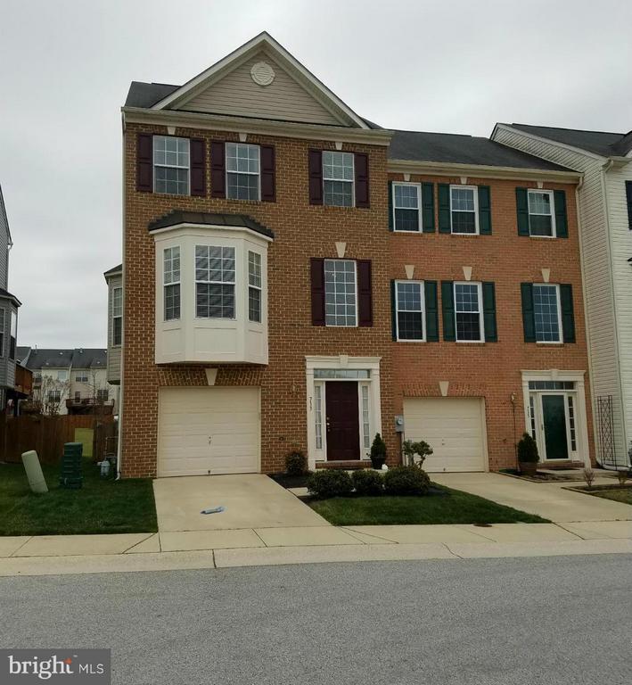
713 Tin Roof Ct
Odenton, MD 21113
Today
Favorites
301-503-3968
-
Bedrooms
3
-
Bathrooms
3
-
Square Feet
2,516 sq ft
-
Available
Available Aug 24
Highlights
- Fitness Center
- Clubhouse
- Deck
- Vaulted Ceiling
- Traditional Floor Plan
- Traditional Architecture
713 Tin Roof Ct

Favorites
About This Home
Available Aug 24
Available October 1st. Discover the perfect blend of comfort and convenience in this beautifully maintained end-unit townhome, nestled in the Piney Orchard community. With three finished levels, this spacious home offers: 3 Bedrooms, 3 Bathrooms, gourmet kitchen with premium finishes, two cozy fireplaces for added charm, primary suite with super bath, private deck, fully fenced backyard, and an attached 1-car garage. Enjoy access to all Piney Orchard amenities—including pools, trails, fitness centers, and more—just a short walk from your front door. This is a non-smoking property. Pets and pet deposits are considered on a case-by-case basis. Interior pictures will be posted soon.
713 Tin Roof Ct is a townhome located in Anne Arundel County and the 21113 ZIP Code. This area is served by the Anne Arundel County Public Schools attendance zone.
* Price shown is base rent and may not include non-optional fees and utilities. Price, availability, fees, and any applicable rent special are subject to change without notice.
* Square footage definitions vary. Displayed square footage is approximate.
Home Details
Home Type
End Unit Townhome
Year Built
Built in 2004
Bedrooms and Bathrooms
Walk-In Closet
En-Suite Primary Bedroom
3 Full Bathrooms
En-Suite Bathroom
3 Bedrooms
Home Design
Traditional Architecture
Brick Exterior Construction
Asphalt Roof
Slab Foundation
Interior Spaces
Vaulted Ceiling
Traditional Floor Plan
2 Fireplaces
Bay Window
Living Room
Recessed Lighting
Sliding Doors
Combination Kitchen and Dining Room
Ceiling Fan
Family Room
Carpet
Gas Fireplace
2,516 Sq Ft Home
Fireplace With Glass Doors
Property has 3 Levels
Kitchen
Breakfast Room
Eat-In Kitchen
Kitchen Island
Ice Maker
Microwave
Dishwasher
Disposal
Laundry
Laundry Room
Dryer
Washer
Listing and Financial Details
Security Deposit $2,950
12-Month Min and 48-Month Max Lease Term
Available 10/1/25
$55 Application Fee
Assessor Parcel Number 020457190219419
Tenant pays for exterior maintenance, light bulbs/filters/fuses/alarm care, minor interior maintenance, all utilities, insurance
Rent includes hoa/condo fee, trash removal
No Smoking Allowed
Residential Lease
Lot Details
2,614 Sq Ft Lot
Property is in very good condition
Back Yard Fenced
No Through Street
Backs To Open Common Area
Outdoor Features
Deck
Parking
1 Car Attached Garage
Front Facing Garage
Off-Street Parking
Garage Door Opener
1 Driveway Space
Utilities
Forced Air Heating and Cooling System
Natural Gas Water Heater
Community Details
Amenities
Clubhouse
Community Center
Meeting Room
Party Room
Picnic Area
Common Area
Overview
Property has a Home Owners Association
Piney Orchard Subdivision
Pet Policy
Pets allowed on a case-by-case basis
Recreation
Fitness Center
Community Indoor Pool
Community Pool or Spa Combo
Tennis Courts
Pool Membership Available
Community Basketball Court
Jogging Path
Community Playground
Bike Trail
Contact
- Listed by Page D Pendergrass | Long & Foster Real Estate, Inc.
- Phone Number
- Contact
-
Source
 Bright MLS, Inc.
Copyright © 2025 Bright MLS, Inc.
Location
Get Directions
Amenities
- Fireplace
- Dishwasher
Situated in Anne Arundel County, Odenton is centrally located between Annapolis, Washington D.C., and Baltimore. The city is continuously growing in population, largely due to its proximity to Fort George G. Meade military base and the developing Piney Orchard neighborhood.
In Odenton, you’ll discover a lot of great shopping centers like Waugh Chapel Towne Centre. Hikers will enjoy the plethora of trails that reside within the community, including Little Patuxent River Trail, Wild Turkey Way, and Merganser Pond Trail, among others. Midland Park is a large green space just minutes from Bowie State University. This Baltimore suburb contains highly rated public schools, plus access to Interstate 97 and Odenton Station.
Learn more about living in Odenton
Education
| Colleges & Universities | Distance | ||
|---|---|---|---|
| Colleges & Universities | Distance | ||
| Drive: | 26 min | 12.6 mi | |
| Drive: | 29 min | 15.8 mi | |
| Drive: | 32 min | 18.8 mi | |
| Drive: | 34 min | 21.1 mi |
713 Tin Roof Ct is within 26 minutes or 12.6 miles from Bowie State University. It is also near Anne Arundel Community College and United States Naval Academy.
Schools


Public Elementary School
Grades PK-5
671 Students
Attendance Zone
Public Middle School
Grades 6-8
1,286 Students
Attendance Zone
Public High School
Grades 9-12
1,617 Students
Attendance Zone
Private Elementary & Middle School
Grades PK-8
736 Students
Nearby
Private Elementary School
Grades PK-4
Nearby
Private Elementary, Middle & High School
Grades PK-12
181 Students
Nearby
School data provided by
 The GreatSchools Rating helps parents compare schools within a state based on a variety of school quality indicators and provides a helpful picture of how effectively each school serves all of its students. Ratings are on a scale of 1 (below average) to 10 (above average) and can include test scores, college readiness, academic progress, advanced courses, equity, discipline and attendance data. We also advise parents to visit schools, consider other information on school performance and programs, and consider family needs as part of the school selection process.
View GreatSchools Rating Methodology
Data provided by GreatSchools.org © 2025. All rights reserved.
View GreatSchools Rating Methodology
Data provided by GreatSchools.org © 2025. All rights reserved.
Transportation options available in Odenton include Bwi Business District, located 11.9 miles from 713 Tin Roof Ct. 713 Tin Roof Ct is near Baltimore/Washington International Thurgood Marshall, located 11.9 miles or 23 minutes away, and Ronald Reagan Washington Ntl, located 33.1 miles or 51 minutes away.
| Transit / Subway | Distance | ||
|---|---|---|---|
| Transit / Subway | Distance | ||
|
|
Drive: | 23 min | 11.9 mi |
|
|
Drive: | 24 min | 12.2 mi |
|
|
Drive: | 23 min | 12.3 mi |
|
|
Drive: | 22 min | 12.5 mi |
|
|
Drive: | 23 min | 12.8 mi |
| Commuter Rail | Distance | ||
|---|---|---|---|
| Commuter Rail | Distance | ||
|
|
Drive: | 8 min | 3.7 mi |
|
|
Drive: | 21 min | 11.5 mi |
|
|
Drive: | 24 min | 12.3 mi |
|
Bowie State Marc Nb
|
Drive: | 26 min | 12.7 mi |
|
Bowie State Marc Sb
|
Drive: | 25 min | 14.1 mi |
| Airports | Distance | ||
|---|---|---|---|
| Airports | Distance | ||
|
Baltimore/Washington International Thurgood Marshall
|
Drive: | 23 min | 11.9 mi |
|
Ronald Reagan Washington Ntl
|
Drive: | 51 min | 33.1 mi |
Time and distance from 713 Tin Roof Ct.
| Shopping Centers | Distance | ||
|---|---|---|---|
| Shopping Centers | Distance | ||
| Drive: | 4 min | 1.5 mi | |
| Drive: | 8 min | 3.6 mi | |
| Drive: | 10 min | 4.7 mi |
713 Tin Roof Ct has 3 shopping centers within 4.7 miles, which is about a 10-minute drive. The miles and minutes will be for the farthest away property.
| Parks and Recreation | Distance | ||
|---|---|---|---|
| Parks and Recreation | Distance | ||
|
Patuxent Research Refuge - North Tract
|
Drive: | 19 min | 9.3 mi |
|
Kinder Farm Park
|
Drive: | 24 min | 12.1 mi |
|
Howard Owens Science Center
|
Drive: | 30 min | 16.6 mi |
|
NASA Goddard Space Flight Center
|
Drive: | 32 min | 17.4 mi |
|
Patuxent Research Refuge - South Tract
|
Drive: | 33 min | 17.4 mi |
713 Tin Roof Ct has 5 parks within 17.4 miles, including Patuxent Research Refuge - North Tract, Kinder Farm Park, and Howard Owens Science Center.
| Hospitals | Distance | ||
|---|---|---|---|
| Hospitals | Distance | ||
| Drive: | 22 min | 12.5 mi | |
| Drive: | 29 min | 15.2 mi | |
| Drive: | 32 min | 18.1 mi |
713 Tin Roof Ct has 3 hospitals within 18.1 miles, the nearest is University of Maryland Baltimore Washington Medical Center which is 12.5 miles away and a 22 minute drive.
| Military Bases | Distance | ||
|---|---|---|---|
| Military Bases | Distance | ||
| Drive: | 15 min | 6.9 mi |
713 Tin Roof Ct is 6.9 miles and a 15 minute drive from Fort George Meade.
You May Also Like
Similar Rentals Nearby


What Are Walk Score®, Transit Score®, and Bike Score® Ratings?
Walk Score® measures the walkability of any address. Transit Score® measures access to public transit. Bike Score® measures the bikeability of any address.
What is a Sound Score Rating?
A Sound Score Rating aggregates noise caused by vehicle traffic, airplane traffic and local sources
713 Tin Roof Ct
Odenton, MD 21113