
$3,950
Total Monthly Price
69 Westmoreland St Unit 2
Boston, MA 02124
Favorites
207-252-6771
-
Bedrooms
4
-
Bathrooms
1
-
Square Feet
1,800 sq ft
-
Available
Available Sep 1
Highlights
- Fenced Yard
- No Cooling
- Heating System Uses Oil
69 Westmoreland St Unit 2

Favorites
About This Home
$3,950 deposit,
Available Sep 1
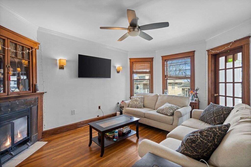
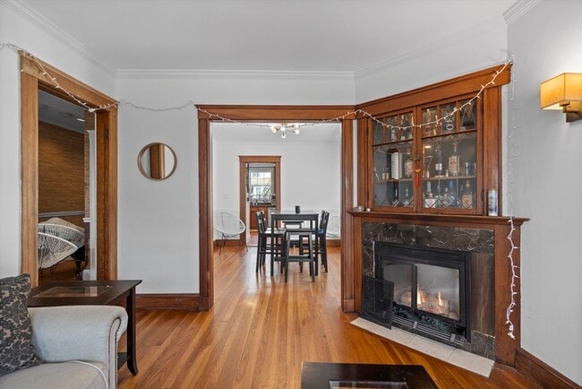
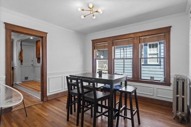
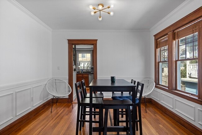
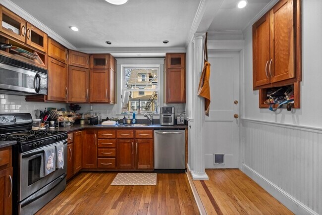
Available September 1! Sprawling bi-level home nestled in the charming Adam's Village. This expansive residence offers over 1,800 square feet of comfortable living space,boasting 4 bedrooms alongside 2 flexible rooms that could be utilized for home office use. The first floor presents a welcoming living room with an attached sunroom,a gracious dining room,and a well-appointed eat-in kitchen featuring a cozy breakfast nook. Completing this level are two bedrooms,along with a bonus room suitable for an in-home office or gym. Ascend to the upper level to discover 2 additional bedrooms,an in-unit washer and dryer,and extra storage space. Outside,the shared backyard comes with outdoor furniture. Enjoy the convenience of a prime location with effortless access to I-93 and the Red Line T at Ashmont. MLS ID 73518996
69 Westmoreland St is a condo located in Suffolk County and the 02124 ZIP Code.
* Price shown is total price based on community-supplied monthly required fees. Excludes user-selected optional fees and variable or usage-based fees and required charges due at or prior to move-in or at move-out. Price, availability, fees, and any applicable rent special are subject to change without notice.
* Square footage definitions vary. Displayed square footage is approximate.
Home Details
Home Type
Condominium
Bedrooms and Bathrooms
1 Full Bathroom
4 Bedrooms
Home Design
Entry on the 2nd floor
Interior Spaces
1,800 Sq Ft Home
Laundry
Laundry in unit
Listing and Financial Details
Security Deposit $3,950
Property Available on 9/1/26
12 Month Lease Term
Assessor Parcel Number 1314657
Rent includes water, sewer
Lot Details
9,999 Sq Ft Lot
Fenced Yard
Utilities
No Cooling
Heating System Uses Oil
Community Details
Amenities
Common Area
Overview
No Home Owners Association
Pet Policy
No Pets Allowed
Fees and Policies
The fees listed below are community-provided and may exclude utilities or add-ons. All payments are made directly to the property and are non-refundable unless otherwise specified. Use the Cost Calculator to determine costs based on your needs.
-
One-Time Basics
-
Due at Move-In
-
Security Deposit - RefundableCharged per unit.$3,950
-
-
Due at Move-In
Property Fee Disclaimer: Based on community-supplied data and independent market research. Subject to change without notice. May exclude fees for mandatory or optional services and usage-based utilities.
Details
Utilities Included
-
Water
-
Sewer
Contact
- Listed by Aranson Maguire Group | Compass
- Phone Number
-
Source
 MLS Property Information Network
The property listing data and information set forth herein were provided to MLS Property Information Network, Inc. from third party sources, including sellers, lessors and public records, and were compiled by MLS Property Information Network, Inc. The property listing data and information are for the personal, non-commercial use of consumers having a good faith interest in purchasing or leasing listed properties of the type displayed to them and may not be used for any purpose other than to identify prospective properties which such consumers may have a good faith interest in purchasing or leasing. MLS Property Information Network, Inc. and its subscribers disclaim any and all representations and warranties as to the accuracy of the property listing data and information set forth herein. All properties are subject to prior sale, change or withdrawal. Copyright © 2026 MLS Property Information Network, Inc. All rights reserved.
Location
Get Directions
Ashmont is a charming suburban district on the southern end of Boston’s Dorchester area. Several public parks are easily accessible from anywhere in the neighborhood, including the huge Dorchester Park to the south and Roberts Playground on the west side.
Walking to the numerous schools and libraries is a breeze, and the rows of shops, cafes, and pubs along Adams Street and Dorchester Avenue can be quickly reached on foot as well. With Carney Hospital nearby, Ashmont is an excellent location for healthcare professionals.
Downtown Boston is only about twenty minutes away by car, and MBTA Red Line service puts the whole city at your fingertips even without the use of a personal vehicle.
Learn more about living in Ashmont
Amenities
- Washer/Dryer
- Heating
- Fenced Lot
Expenses
Utilities Included
Water, Sewer
Included
Education
| Colleges & Universities | Distance | ||
|---|---|---|---|
| Colleges & Universities | Distance | ||
| Drive: | 8 min | 3.9 mi | |
| Drive: | 11 min | 6.2 mi | |
| Drive: | 12 min | 6.4 mi | |
| Drive: | 11 min | 6.7 mi |
69 Westmoreland St Unit 2 is within 8 minutes or 3.9 miles from UMass Boston. It is also near Northeastern University and Wentworth Inst. of Technology.
Transportation options available in Boston include Ashmont Station, located 0.3 mile from 69 Westmoreland St Unit 2. 69 Westmoreland St Unit 2 is near General Edward Lawrence Logan International, located 9.3 miles or 16 minutes away.
| Transit / Subway | Distance | ||
|---|---|---|---|
| Transit / Subway | Distance | ||
|
|
Walk: | 5 min | 0.3 mi |
|
|
Walk: | 8 min | 0.5 mi |
|
|
Walk: | 18 min | 1.0 mi |
|
|
Walk: | 20 min | 1.1 mi |
|
|
Drive: | 3 min | 1.4 mi |
| Commuter Rail | Distance | ||
|---|---|---|---|
| Commuter Rail | Distance | ||
| Drive: | 3 min | 1.3 mi | |
|
|
Drive: | 3 min | 1.7 mi |
| Drive: | 6 min | 2.3 mi | |
| Drive: | 5 min | 2.7 mi | |
|
|
Drive: | 7 min | 3.1 mi |
| Airports | Distance | ||
|---|---|---|---|
| Airports | Distance | ||
|
General Edward Lawrence Logan International
|
Drive: | 16 min | 9.3 mi |
Getting Around
 What do Walkability, Transit, Drivability, and Bikeability mean?
Walkability measures the walking distance to day-to-day needs.
Transit measures access to public transportation.
Drivability measures congestion, parking availability, and access to major roads.
Bikeability measures the suitability for cycling.
How It Works
What do Walkability, Transit, Drivability, and Bikeability mean?
Walkability measures the walking distance to day-to-day needs.
Transit measures access to public transportation.
Drivability measures congestion, parking availability, and access to major roads.
Bikeability measures the suitability for cycling.
How It Works
Very Walkable
Walkability
80
/ 100
Good Public Transit
Transit
60
/ 100
Moderately Drivable
Drivability
60
/ 100
Moderately Bikeable
Bikeability
60
/ 100
Scores provided by
Active
Soundscore™
74
/ 100
Traffic
BusyAirport
CalmBusinesses
ActiveScores provided by
HowLoud What is a Sound Score Rating? A Sound Score Rating aggregates noise caused by vehicle traffic, airplane traffic and local sources. How It WorksTime and distance from 69 Westmoreland St Unit 2.
| Shopping Centers | Distance | ||
|---|---|---|---|
| Shopping Centers | Distance | ||
| Walk: | 6 min | 0.3 mi | |
| Walk: | 16 min | 0.9 mi | |
| Drive: | 4 min | 1.8 mi |
69 Westmoreland St Unit 2 has 3 shopping centers within 1.8 miles, which is about a 4-minute drive. The miles and minutes will be for the farthest away property.
| Parks and Recreation | Distance | ||
|---|---|---|---|
| Parks and Recreation | Distance | ||
|
Mass Audubon's Boston Nature Center and Wildlife Sanctuary
|
Drive: | 6 min | 2.9 mi |
|
Squantum Point Park
|
Drive: | 8 min | 3.2 mi |
|
Franklin Park Zoo
|
Drive: | 6 min | 3.5 mi |
|
Lower Neponset River Trail
|
Drive: | 6 min | 3.6 mi |
|
Dorchester Shores Reservation
|
Drive: | 7 min | 3.9 mi |
69 Westmoreland St Unit 2 has 5 parks within 3.9 miles, including Franklin Park Zoo, Lower Neponset River Trail, and Mass Audubon's Boston Nature Center and Wildlife Sanctuary.
| Hospitals | Distance | ||
|---|---|---|---|
| Hospitals | Distance | ||
| Walk: | 13 min | 0.7 mi | |
| Drive: | 6 min | 2.9 mi | |
| Drive: | 9 min | 5.4 mi |
69 Westmoreland St Unit 2 has 3 hospitals within 5.4 miles, the nearest is Carney Hospital which is 0.7 mile away and a 13 minute walk.
| Military Bases | Distance | ||
|---|---|---|---|
| Military Bases | Distance | ||
| Drive: | 34 min | 19.7 mi | |
| Drive: | 40 min | 21.6 mi | |
| Drive: | 41 min | 24.0 mi |
69 Westmoreland St Unit 2 has 3 military bases within 24.0 miles, the nearest is US Military Reservation which is 19.7 miles away and a 34 minute drive.
You May Also Like
Similar Rentals Nearby
-
-
 4 Beds$6,500Total Monthly Price12 Month LeaseTotal Monthly Price NewPrices include all required monthly fees.Condo for Rent
 -

-

-

-

-

-

-

-


69 Westmoreland St
Boston, MA 02124