
Presidential Towers
555 W Madison St,
Chicago, IL 60661
$1,778 - $5,122
Studio - 2 Beds
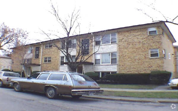

Welcome to 6832-6834 N Northwest Hwy. These apartments are located at 6832-6834 N. Northwest Hwy. in the 60631 area of Chicago. The professional leasing staff is ready to help you find your new apartment. Come by to see the available floorplan options. Contact us or stop by today.
6832-6834 N Northwest Hwy is an apartment community located in Cook County and the 60631 ZIP Code. This area is served by the Chicago Public Schools attendance zone.
Located in northwest Chicago, Edison Park is a charming, safe neighborhood great for all ages. Whether you have a family and you’re looking for a great school district or you’re a single adult looking for a party, Edison Park is the perfect place for you to live. Plus, compared to other Chicago neighborhoods, Edison Park is one of the most affordable neighborhoods with plenty of rental options!
In Edison Park, you’ll find lively community parks with recreational activities and an abundance of Italian restaurants and Irish pubs. High-ranking Chicago Public Schools reside in this area such as Ebinger Elementary and Stock Elementary. Edison Park is wonderfully convenient with nearby grocery stores, churches, and local businesses, and it’s just a few miles northeast of the O’Hare International Airport for quick and easy travels.
Learn more about living in Edison ParkCompare neighborhood and city base rent averages by bedroom.
| Edison Park | Chicago, IL | |
|---|---|---|
| Studio | $775 | $1,633 |
| 1 Bedroom | $1,210 | $2,031 |
| 2 Bedrooms | $1,460 | $2,547 |
| 3 Bedrooms | $1,456 | $3,058 |
| Colleges & Universities | Distance | ||
|---|---|---|---|
| Colleges & Universities | Distance | ||
| Drive: | 9 min | 4.3 mi | |
| Drive: | 10 min | 5.4 mi | |
| Drive: | 13 min | 6.1 mi | |
| Drive: | 12 min | 6.5 mi |


Transportation options available in Chicago include Harlem Station (Blue Line - O'hare Branch), located 2.3 miles from 6832-6834 N Northwest Hwy. 6832-6834 N Northwest Hwy is near Chicago O'Hare International, located 6.0 miles or 11 minutes away, and Chicago Midway International, located 17.5 miles or 32 minutes away.
| Transit / Subway | Distance | ||
|---|---|---|---|
| Transit / Subway | Distance | ||
|
|
Drive: | 4 min | 2.3 mi |
|
|
Drive: | 8 min | 3.9 mi |
|
|
Drive: | 8 min | 4.8 mi |
|
|
Drive: | 9 min | 5.0 mi |
|
|
Drive: | 10 min | 5.1 mi |
| Commuter Rail | Distance | ||
|---|---|---|---|
| Commuter Rail | Distance | ||
|
|
Walk: | 7 min | 0.4 mi |
|
|
Walk: | 15 min | 0.8 mi |
|
|
Drive: | 3 min | 1.6 mi |
|
|
Drive: | 5 min | 2.6 mi |
|
|
Drive: | 9 min | 4.2 mi |
| Airports | Distance | ||
|---|---|---|---|
| Airports | Distance | ||
|
Chicago O'Hare International
|
Drive: | 11 min | 6.0 mi |
|
Chicago Midway International
|
Drive: | 32 min | 17.5 mi |
Scores provided by
Traffic
-Airport
-Businesses
-Scores provided by
HowLoud What is a Sound Score Rating? A Sound Score Rating aggregates noise caused by vehicle traffic, airplane traffic and local sources. How It WorksTime and distance from 6832-6834 N Northwest Hwy.
| Shopping Centers | Distance | ||
|---|---|---|---|
| Shopping Centers | Distance | ||
| Walk: | 11 min | 0.6 mi | |
| Walk: | 12 min | 0.6 mi | |
| Walk: | 13 min | 0.7 mi |
| Parks and Recreation | Distance | ||
|---|---|---|---|
| Parks and Recreation | Distance | ||
|
Caldwell Woods
|
Drive: | 3 min | 1.9 mi |
|
Norwood Park
|
Drive: | 4 min | 1.9 mi |
|
Oriole Park
|
Drive: | 5 min | 2.6 mi |
|
Dam No. 4 Woods-East
|
Drive: | 6 min | 2.9 mi |
|
Bunker Hill / Clayton Smith Preserves
|
Drive: | 6 min | 2.9 mi |
| Hospitals | Distance | ||
|---|---|---|---|
| Hospitals | Distance | ||
| Drive: | 3 min | 1.5 mi | |
| Drive: | 6 min | 3.3 mi | |
| Drive: | 9 min | 4.2 mi |
| Military Bases | Distance | ||
|---|---|---|---|
| Military Bases | Distance | ||
| Drive: | 19 min | 10.6 mi |
What Are Walk Score®, Transit Score®, and Bike Score® Ratings?
Walk Score® measures the walkability of any address. Transit Score® measures access to public transit. Bike Score® measures the bikeability of any address.
What is a Sound Score Rating?
A Sound Score Rating aggregates noise caused by vehicle traffic, airplane traffic and local sources.

6832-6834 N Northwest Hwy
Chicago, IL 60631


