
$10,300
Total Monthly Price
6801 Danforth St
McLean, VA 22101
Favorites
703-338-8919
-
Bedrooms
6
-
Bathrooms
5.5
-
Square Feet
4,269 sq ft
-
Available
Available Now
Highlights
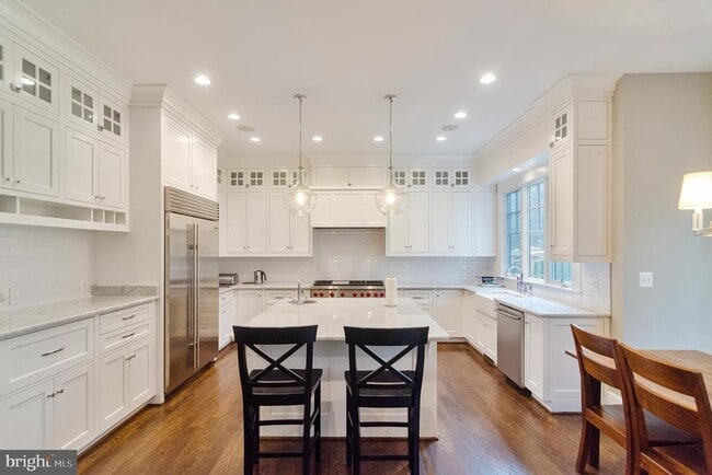
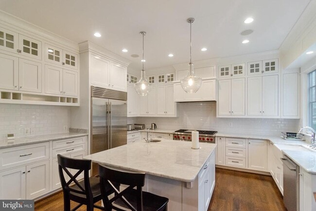
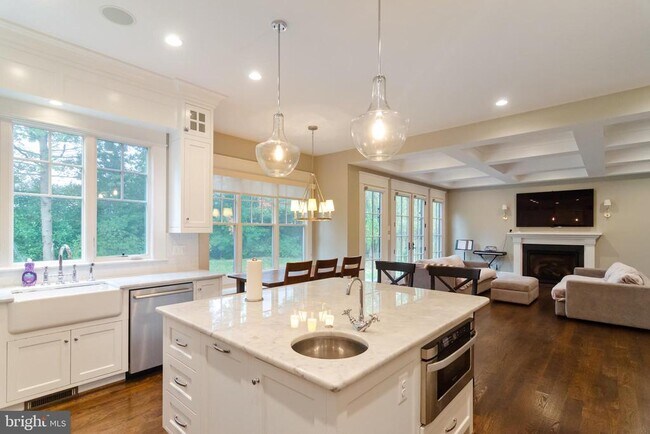
- Gourmet Kitchen
- Open Floorplan
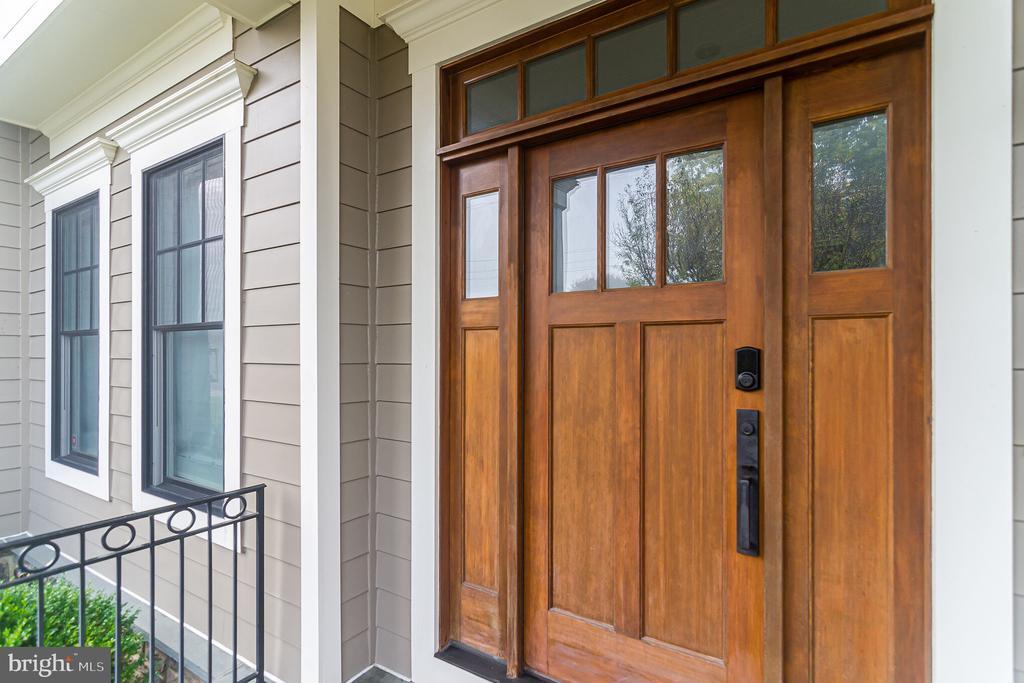
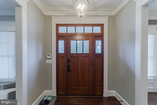
- A-Frame Home
- Wolf Appliances
- Wood Flooring
- Main Floor Bedroom
6801 Danforth St

Favorites
About This Home
Available Now
Stunning Arts & Crafts Luxury home from Highly esteemed Georgetown Homes. Gorgeous new home features a Chef's Dream Kitchen w/custom cabinetry, oversized island, marble counters, & Wolf/Subzero/Bosch appliances, Spacious Bdrms, Main Level Study/Bdrm, beautifully finished Lower Lvl, storage shed, brick paver-patio on quiet lot! Close to schools! Truly A Must See!
6801 Danforth St is a house located in Fairfax County and the 22101 ZIP Code. This area is served by the Fairfax County Public Schools attendance zone.
* Price shown is total price based on community-supplied monthly required fees. Excludes user-selected optional fees and variable or usage-based fees and required charges due at or prior to move-in or at move-out. Price, availability, fees, and any applicable rent special are subject to change without notice.
* Square footage definitions vary. Displayed square footage is approximate.
Home Details
Home Type
Single Family Detached Home
Year Built
Built in 2014
Accessible Home Design
Level Entry For Accessibility
Halls are 48 inches wide or more
Bedrooms and Bathrooms
Soaking Tub
6 Bedrooms | 1 Main Level Bedroom
5.5 Bathrooms
En-Suite Bathroom
Finished Basement
Walk-Out Basement
Basement Fills Entire Space Under The House
Rear Basement Entry
Home Design
A-Frame Home
Asphalt Roof
Concrete Perimeter Foundation
Home Security
Flood Lights
Interior Spaces
Open Floorplan
Wood Flooring
Furnished
Family Room Off Kitchen
Chair Railings
Built-In Features
Wet Bar
Bar
Crown Molding
Recessed Lighting
Ceiling height of 9 feet or more
Gas Fireplace
4,269 Sq Ft Home
Fireplace With Glass Doors
Property has 3 Levels
Window Treatments
Kitchen
Gourmet Kitchen
Wolf Appliances
Upgraded Countertops
Breakfast Area or Nook
Six Burner Stove
Double Oven
Stainless Steel Appliances
Butlers Pantry
Bosch Dishwasher
Kitchen Island
Gas Oven or Range
Ice Maker
Built-In Microwave
Dishwasher
Range Hood
Disposal
Laundry
Dryer
Laundry on upper level
Washer
Listing and Financial Details
Security Deposit $10,300
12-Month Min and 36-Month Max Lease Term
Available 6/1/26
Assessor Parcel Number 0304 17 0129
Residential Lease
Lot Details
10,500 Sq Ft Lot
Property is in very good condition
Property is Fully Fenced
Property is zoned 130
Sprinkler System
Outdoor Features
Porch
Patio
Parking
2 Car Garage
Assigned Parking Garage Space
Front Facing Garage
Schools
Mclean High School
Utilities
Forced Air Heating and Cooling System
Heating System Uses Natural Gas
Electric Water Heater
Cooling System Utilizes Natural Gas
Vented Exhaust Fan
Community Details
Overview
No Home Owners Association
Built by Georgetown Homes
Mclean Manor Subdivision, Lauren Floorplan
Pet Policy
Pets allowed on a case-by-case basis
Contact
- Listed by Amy Wang | Samson Properties
- Phone Number
- Contact
-
Source
 Bright MLS, Inc.
Copyright © 2026 Bright MLS, Inc.
Location
Get Directions
McLean, Virginia combines suburban tranquility with convenient access to Washington, D.C. Located just minutes from the nation's capital, this Northern Virginia community spans nearly 25 square miles of tree-lined streets and established neighborhoods. The rental market offers a range of options, with average rents from $2,434 for studios to $5,156 for three-bedroom units.
McLean's outdoor spaces include Clemyjontri Park, featuring accessible playground equipment and recreational facilities. The community's location along the Potomac River provides opportunities for hiking and outdoor recreation, while shopping destinations like Tysons Corner Center and Tysons Galleria offer retail and dining options.
The Langley area houses the Central Intelligence Agency headquarters, and the recently completed Silver Line Metro station connects residents to the greater Washington metropolitan area. McLean's downtown area features locally owned shops and restaurants.
Learn more about living in McLean
Amenities
- Fireplace
- Dishwasher
- Basement
Education
| Colleges & Universities | Distance | ||
|---|---|---|---|
| Colleges & Universities | Distance | ||
| Drive: | 9 min | 3.8 mi | |
| Drive: | 15 min | 6.0 mi | |
| Drive: | 15 min | 6.4 mi | |
| Drive: | 16 min | 6.8 mi |
6801 Danforth St is within 9 minutes or 3.8 miles from Marymount University. It is also near George Mason Univ., Arlington and GWU, Mount Vernon.
Schools


Public Elementary School
Grades PK-5
1,023 Students
Attendance Zone
Public Middle School
Grades 6-8
1,225 Students
Attendance Zone
Public High School
Grades 9-12
2,438 Students
Attendance Zone
Private Elementary School
Grades PK-5
29 Students
Nearby
Private Elementary & Middle School
Grades PK-8
256 Students
Nearby
School data provided by
 The GreatSchools Rating helps parents compare schools within a state based on a variety of school quality indicators and provides a helpful picture of how effectively each school serves all of its students. Ratings are on a scale of 1 (below average) to 10 (above average) and can include test scores, college readiness, academic progress, advanced courses, equity, discipline and attendance data. We also advise parents to visit schools, consider other information on school performance and programs, and consider family needs as part of the school selection process.
View GreatSchools Rating Methodology
Data provided by GreatSchools.org © 2026. All rights reserved.
View GreatSchools Rating Methodology
Data provided by GreatSchools.org © 2026. All rights reserved.
Transportation options available in McLean include Mclean, located 2.1 miles from 6801 Danforth St. 6801 Danforth St is near Ronald Reagan Washington Ntl, located 11.8 miles or 25 minutes away, and Washington Dulles International, located 16.8 miles or 29 minutes away.
| Transit / Subway | Distance | ||
|---|---|---|---|
| Transit / Subway | Distance | ||
|
|
Drive: | 5 min | 2.1 mi |
|
|
Drive: | 7 min | 3.0 mi |
|
|
Drive: | 9 min | 4.0 mi |
|
|
Drive: | 17 min | 8.3 mi |
|
|
Drive: | 19 min | 11.0 mi |
| Commuter Rail | Distance | ||
|---|---|---|---|
| Commuter Rail | Distance | ||
|
|
Drive: | 22 min | 10.5 mi |
|
|
Drive: | 23 min | 11.4 mi |
| Drive: | 25 min | 13.8 mi | |
|
|
Drive: | 24 min | 14.0 mi |
| Drive: | 25 min | 15.1 mi |
| Airports | Distance | ||
|---|---|---|---|
| Airports | Distance | ||
|
Ronald Reagan Washington Ntl
|
Drive: | 25 min | 11.8 mi |
|
Washington Dulles International
|
Drive: | 29 min | 16.8 mi |
Getting Around
 What do Walkability, Transit, Drivability, and Bikeability mean?
Walkability measures the walking distance to day-to-day needs.
Transit measures access to public transportation.
Drivability measures congestion, parking availability, and access to major roads.
Bikeability measures the suitability for cycling.
How It Works
What do Walkability, Transit, Drivability, and Bikeability mean?
Walkability measures the walking distance to day-to-day needs.
Transit measures access to public transportation.
Drivability measures congestion, parking availability, and access to major roads.
Bikeability measures the suitability for cycling.
How It Works
Fairly Walkable
Walkability
50
/ 100
Limited Public Transit
Transit
30
/ 100
Exceptionally Drivable
Drivability
90
/ 100
Moderately Bikeable
Bikeability
60
/ 100
Scores provided by
Active
Soundscore™
76
/ 100
Traffic
BusyAirport
CalmBusinesses
CalmScores provided by
HowLoud What is a Sound Score Rating? A Sound Score Rating aggregates noise caused by vehicle traffic, airplane traffic and local sources. How It WorksTime and distance from 6801 Danforth St.
| Shopping Centers | Distance | ||
|---|---|---|---|
| Shopping Centers | Distance | ||
| Walk: | 10 min | 0.5 mi | |
| Walk: | 9 min | 0.5 mi | |
| Walk: | 12 min | 0.6 mi |
6801 Danforth St has 3 shopping centers within 0.6 mile, which is about a 12-minute walk. The miles and minutes will be for the farthest away property.
| Parks and Recreation | Distance | ||
|---|---|---|---|
| Parks and Recreation | Distance | ||
|
Clemyjontri Park
|
Drive: | 7 min | 3.1 mi |
|
W&OD Trail
|
Drive: | 8 min | 3.2 mi |
|
Rock Spring Park
|
Drive: | 8 min | 3.2 mi |
|
Claude Moore Colonial Farm
|
Drive: | 10 min | 3.6 mi |
|
Lyndon Baines Johnson Memorial Grove
|
Drive: | 12 min | 6.2 mi |
6801 Danforth St has 5 parks within 6.2 miles, including Clemyjontri Park, Claude Moore Colonial Farm, and W&OD Trail.
| Hospitals | Distance | ||
|---|---|---|---|
| Hospitals | Distance | ||
| Drive: | 11 min | 4.6 mi | |
| Drive: | 12 min | 5.1 mi | |
| Drive: | 14 min | 6.1 mi |
6801 Danforth St has 3 hospitals within 6.1 miles, the nearest is Virginia Hospital Center which is 4.6 miles away and a 11 minute drive.
| Military Bases | Distance | ||
|---|---|---|---|
| Military Bases | Distance | ||
| Drive: | 20 min | 8.4 mi | |
| Drive: | 20 min | 8.8 mi | |
| Drive: | 19 min | 9.2 mi |
6801 Danforth St has 3 military bases within 9.2 miles, the nearest is Naval Observatory which is 8.4 miles away and a 20 minute drive.
You May Also Like
Similar Rentals Nearby


6801 Danforth St
McLean, VA 22101