
$2,200
/ Month
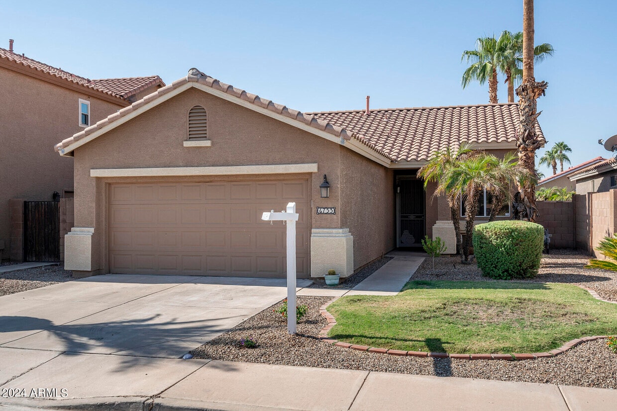
6753 W Linda Ln
Chandler, AZ 85226
Favorites
6753 W Linda Ln

Favorites
Check Back Soon for Upcoming Availability
| Beds | Baths | Average SF |
|---|---|---|
| 3 Bedrooms 3 Bedrooms 3 Br | 2 Baths 2 Baths 2 Ba | 1,218 SF |
About This Property
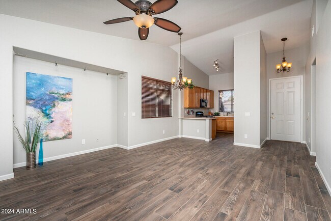
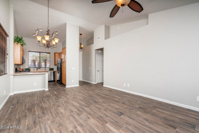
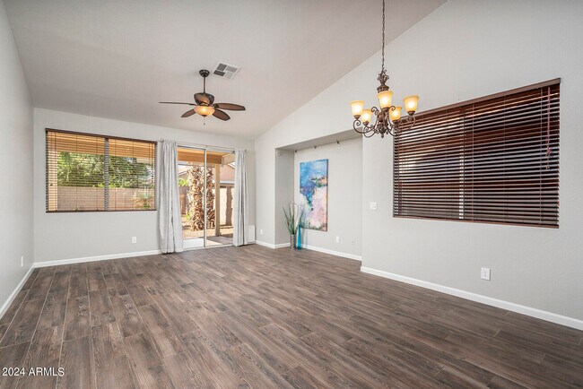
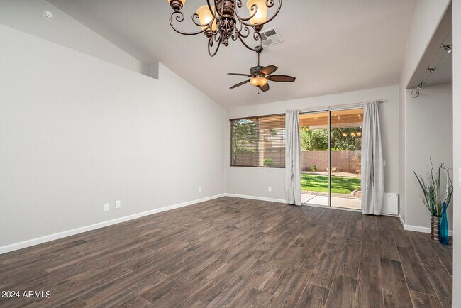
Beautiful & immaculate home in Chandler Crossing! Single level,3 bedrooms,2 baths,2-car garage,great-room plan with wonderful back yard. All tile floors - no carpet. Gas stove/oven,gas heating & water heater. Includes Maytag washer/dryer,GE refrigerator,built-in microwave,newer dishwasher,plus R/O water system. Peaceful & quiet back yard with grass,trees,plus covered patio. Close to everything - shopping,freeways,restaurants,within Kyrene and Tempe Union High School districts. This home has never been rented before,shows great pride of ownership! Owner is looking for tenants w/great credit,will consider one small pet. Owner will manage with great communication and responsiveness,and no ''extra'' fees. Available immediately - come see this charming home soon!
6753 W Linda Ln is a house located in Maricopa County and the 85226 ZIP Code. This area is served by the Kyrene Elementary School District attendance zone.
6753 W Linda Ln,
Chandler,
AZ
85226
Situated about four miles west of Downtown Chandler, West Chandler is a scenic suburb brimming with recreation and retail. West Chandler residents enjoy access to an array of local parks, including Desert Breeze Park, Nozomi Park, and Hanger Park, as well as close proximity to the sprawling South Mountain Park.
Retail options in West Chandler provide a host of modern delights and everyday conveniences, with numerous shopping centers and plazas strewn throughout the area in addition to the upscale Chandler Fashion Center. West Chandler is also convenient to the popular Lone Butte Casino. Getting around from West Chandler is easy with access to the Santan Freeway, Maricopa Freeway, and the Price Freeway.
Learn more about living in West ChandlerBelow are rent ranges for similar nearby apartments
| Beds | Average Size | Lowest | Typical | Premium |
|---|---|---|---|---|
| Studio Studio Studio | 521 Sq Ft | $1,095 | $1,915 | $3,856 |
| 1 Bed 1 Bed 1 Bed | 759 Sq Ft | $1,112 | $2,058 | $14,881 |
| 2 Beds 2 Beds 2 Beds | 1094 Sq Ft | $1,211 | $2,376 | $8,370 |
| 3 Beds 3 Beds 3 Beds | 1407 Sq Ft | $1,799 | $3,352 | $24,689 |
| 4 Beds 4 Beds 4 Beds | 2423 Sq Ft | $2,250 | $3,764 | $7,500 |
Education
| Colleges & Universities | Distance | ||
|---|---|---|---|
| Colleges & Universities | Distance | ||
| Drive: | 17 min | 9.3 mi | |
| Drive: | 18 min | 9.9 mi | |
| Drive: | 16 min | 10.1 mi | |
| Drive: | 16 min | 10.2 mi |
6753 W Linda Ln is within 16 minutes or 10.1 miles from Arizona State University. It is also near South Mountain Comm. Coll. and Arizona State Univ., Tempe.
Schools

Public Elementary & Middle School
Grades K-8
565 Students
Attendance Zone
Public Elementary & Middle School
Grades PK-8
377 Students
Attendance Zone
Public High School
Grades 9-12
1,564 Students
Attendance Zone
Private Elementary, Middle & High School
Grades PK-12
327 Students
Nearby
Private Elementary, Middle & High School
Grades K-12
900 Students
Nearby
Private Middle & High School
Grades 6-12
Nearby
School data provided by
 The GreatSchools Rating helps parents compare schools within a state based on a variety of school quality indicators and provides a helpful picture of how effectively each school serves all of its students. Ratings are on a scale of 1 (below average) to 10 (above average) and can include test scores, college readiness, academic progress, advanced courses, equity, discipline and attendance data. We also advise parents to visit schools, consider other information on school performance and programs, and consider family needs as part of the school selection process.
View GreatSchools Rating Methodology
Data provided by GreatSchools.org © 2026. All rights reserved.
View GreatSchools Rating Methodology
Data provided by GreatSchools.org © 2026. All rights reserved.
Transportation options available in Chandler include Eleventh St/Mill, located 9.7 miles from 6753 W Linda Ln. 6753 W Linda Ln is near Phoenix Sky Harbor International, located 11.6 miles or 18 minutes away, and Phoenix-Mesa Gateway, located 20.3 miles or 30 minutes away.
| Transit / Subway | Distance | ||
|---|---|---|---|
| Transit / Subway | Distance | ||
|
|
Drive: | 15 min | 9.7 mi |
|
|
Drive: | 15 min | 9.7 mi |
|
|
Drive: | 15 min | 10.0 mi |
|
|
Drive: | 16 min | 10.4 mi |
|
|
Drive: | 18 min | 11.4 mi |
| Commuter Rail | Distance | ||
|---|---|---|---|
| Commuter Rail | Distance | ||
|
|
Drive: | 28 min | 19.6 mi |
| Airports | Distance | ||
|---|---|---|---|
| Airports | Distance | ||
|
Phoenix Sky Harbor International
|
Drive: | 18 min | 11.6 mi |
|
Phoenix-Mesa Gateway
|
Drive: | 30 min | 20.3 mi |
Walkability Near 6753 W Linda Ln Chandler, AZ 85226
Getting Around
 What do Walkability, Transit, Drivability, and Bikeability mean?
Walkability measures the walking distance to day-to-day needs.
Transit measures access to public transportation.
Drivability measures congestion, parking availability, and access to major roads.
Bikeability measures the suitability for cycling.
How It Works
What do Walkability, Transit, Drivability, and Bikeability mean?
Walkability measures the walking distance to day-to-day needs.
Transit measures access to public transportation.
Drivability measures congestion, parking availability, and access to major roads.
Bikeability measures the suitability for cycling.
How It Works
Fairly Walkable
Walkability
50
/ 100
Limited Public Transit
Transit
20
/ 100
Exceptionally Drivable
Drivability
100
/ 100
Fairly Bikeable
Bikeability
50
/ 100
Scores provided by
-
Soundscore™
-
/ 100
Traffic
-Airport
-Businesses
-Scores provided by
HowLoud What is a Sound Score Rating? A Sound Score Rating aggregates noise caused by vehicle traffic, airplane traffic and local sources. How It WorksTime and distance from 6753 W Linda Ln.
| Shopping Centers | Distance | ||
|---|---|---|---|
| Shopping Centers | Distance | ||
| Walk: | 6 min | 0.4 mi | |
| Walk: | 8 min | 0.4 mi | |
| Walk: | 10 min | 0.6 mi |
6753 W Linda Ln has 3 shopping centers within 0.6 mile, which is about a 10-minute walk. The miles and minutes will be for the farthest away property.
| Parks and Recreation | Distance | ||
|---|---|---|---|
| Parks and Recreation | Distance | ||
|
Pecos Park
|
Drive: | 7 min | 3.1 mi |
|
South Mountain Park
|
Drive: | 12 min | 5.3 mi |
|
ASU Center for Meteorite Studies
|
Drive: | 18 min | 10.5 mi |
|
Desert Arboretum Park
|
Drive: | 19 min | 11.0 mi |
|
Camelback Mountain Park
|
Drive: | 25 min | 13.3 mi |
6753 W Linda Ln has 5 parks within 13.3 miles, including Pecos Park, South Mountain Park, and ASU Center for Meteorite Studies.
| Hospitals | Distance | ||
|---|---|---|---|
| Hospitals | Distance | ||
| Drive: | 8 min | 4.5 mi | |
| Drive: | 9 min | 5.1 mi | |
| Drive: | 12 min | 6.6 mi |
6753 W Linda Ln has 3 hospitals within 6.6 miles, the nearest is Aurora Behavioral Healthcare - Tempe which is 4.5 miles away and a 8 minute drive.
| Military Bases | Distance | ||
|---|---|---|---|
| Military Bases | Distance | ||
| Drive: | 18 min | 12.4 mi | |
| Drive: | 47 min | 36.8 mi | |
| Drive: | 96 min | 78.4 mi |
6753 W Linda Ln has 3 military bases within 78.4 miles, the nearest is Phoenix Sky Harbor Airport Air Guard Station which is 12.4 miles away and a 18 minute drive.
You May Also Like
Similar Rentals Nearby
-
-
-
1 / 73
 3 Beds$2,572+Total Monthly PriceTotal Monthly Price NewPrices include base rent and required monthly fees of $56. Variable costs based on usage may apply.Base Rent:3 Beds$2,515+2 Months Free
Pets Allowed Fitness Center Pool Dishwasher Refrigerator Kitchen
-
-
-
-
-
3 Beds$2,690+Total Monthly PriceTotal Monthly Price NewPrices include base rent and required monthly fees of $264. Variable costs based on usage may apply.Base Rent:3 Beds$2,425+2 Months Free
Pets Allowed Fitness Center Pool Dishwasher Walk-In Closets Stainless Steel Appliances
-
-


What Are Walk Score®, Transit Score®, and Bike Score® Ratings?
Walk Score® measures the walkability of any address. Transit Score® measures access to public transit. Bike Score® measures the bikeability of any address.
What is a Sound Score Rating?
A Sound Score Rating aggregates noise caused by vehicle traffic, airplane traffic and local sources.
6753 W Linda Ln
Chandler, AZ 85226