


$2,000
/ Month
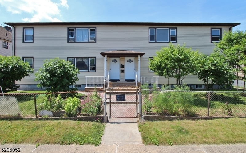
672 Clarkson Ave
Elizabeth, NJ 07202
2 Weeks Ago
Favorites
672 Clarkson Ave

Favorites
Check Back Soon for Upcoming Availability
| Beds | Baths | Average SF |
|---|---|---|
| 2 Bedrooms 2 Bedrooms 2 Br | 1 Bath 1 Bath 1 Ba | — |
Fees and Policies
The fees below are based on community-supplied data and may exclude additional fees and utilities.
About This Property
672-674 Clarkson is AKA 558 Richmond Street (corner property). Second Floor Unit- Welcome to your new home in the vibrant Bayway section of Elizabeth, NJ! This beautifully renovated 2-bedroom, 1-bathroom apartment is completely modernized with brand-new hardwood floors, freshly painted interiors, an updated kitchen, spacious bedrooms, and a sleek bathroom. Located near Newark Liberty International Airport, major highways, and Mattano Park, you'll enjoy easy access to travel, recreation, and vibrant community life. Bayway boasts diverse dining, shopping, cultural attractions, and public transportation including NJ Transit (Elizabeth Station 1.8 miles away). Schedule a viewing today! Landlord requires NTN Credit report, proof of income. No Smoking, No Pets.
672 Clarkson Ave is a house located in Union County and the 07202 ZIP Code. This area is served by the Elizabeth Public attendance zone.
House Features
- Range
- Hardwood Floors
- Fenced Lot
Location
Get Directions
The largest city in Union County, Elizabeth is a bustling town in northeastern New Jersey, centrally located near Staten Island, New York City, Jersey City, and Newark. Elizabeth was built on shipping and industry, but has modernized into a picturesque residential community that’s teeming with urban amenities. This city has a rich history that can be seen through the city’s grand architecture like the Elizabeth Public Library and the Union County Courthouse.
Live music venues, shopping malls, local bars and restaurants, and riverfront green spaces are just a few of the perks of living in this New Jersey suburb. Just outside of Elizabeth, you’ll discover Kean University and Warinanco Park.
Learn more about living in Elizabeth
Amenities
- Range
- Hardwood Floors
- Fenced Lot
Education
| Colleges & Universities | Distance | ||
|---|---|---|---|
| Colleges & Universities | Distance | ||
| Drive: | 5 min | 1.9 mi | |
| Drive: | 8 min | 3.5 mi | |
| Drive: | 11 min | 5.4 mi | |
| Drive: | 19 min | 8.5 mi |
672 Clarkson Ave is within 5 minutes or 1.9 miles from Union County Coll., Elizabeth. It is also near Kean University and Coll. of Staten Island, CUNY.
Schools


Public Elementary & Middle School
Grades PK-8
799 Students
Attendance Zone
Public High School
Grades 9-12
1,299 Students
Attendance Zone
Private Elementary, Middle & High School
Grades PK-12
Nearby
School data provided by
 The GreatSchools Rating helps parents compare schools within a state based on a variety of school quality indicators and provides a helpful picture of how effectively each school serves all of its students. Ratings are on a scale of 1 (below average) to 10 (above average) and can include test scores, college readiness, academic progress, advanced courses, equity, discipline and attendance data. We also advise parents to visit schools, consider other information on school performance and programs, and consider family needs as part of the school selection process.
View GreatSchools Rating Methodology
Data provided by GreatSchools.org © 2025. All rights reserved.
View GreatSchools Rating Methodology
Data provided by GreatSchools.org © 2025. All rights reserved.
Transportation options available in Elizabeth include 8Th Street Light Rail Station, located 6.9 miles from 672 Clarkson Ave. 672 Clarkson Ave is near Newark Liberty International, located 8.2 miles or 14 minutes away, and LaGuardia, located 26.7 miles or 46 minutes away.
| Transit / Subway | Distance | ||
|---|---|---|---|
| Transit / Subway | Distance | ||
| Drive: | 13 min | 6.9 mi | |
|
|
Drive: | 12 min | 7.7 mi |
|
|
Drive: | 14 min | 8.2 mi |
|
|
Drive: | 16 min | 9.0 mi |
|
|
Drive: | 15 min | 10.6 mi |
| Commuter Rail | Distance | ||
|---|---|---|---|
| Commuter Rail | Distance | ||
|
|
Drive: | 5 min | 2.0 mi |
|
|
Drive: | 5 min | 3.1 mi |
|
|
Drive: | 7 min | 3.8 mi |
|
|
Drive: | 8 min | 3.9 mi |
|
|
Drive: | 10 min | 4.4 mi |
| Airports | Distance | ||
|---|---|---|---|
| Airports | Distance | ||
|
Newark Liberty International
|
Drive: | 14 min | 8.2 mi |
|
LaGuardia
|
Drive: | 46 min | 26.7 mi |
Time and distance from 672 Clarkson Ave.
| Shopping Centers | Distance | ||
|---|---|---|---|
| Shopping Centers | Distance | ||
| Drive: | 4 min | 1.6 mi | |
| Drive: | 4 min | 1.8 mi | |
| Drive: | 5 min | 2.0 mi |
672 Clarkson Ave has 3 shopping centers within 2.0 miles, which is about a 5-minute drive. The miles and minutes will be for the farthest away property.
| Parks and Recreation | Distance | ||
|---|---|---|---|
| Parks and Recreation | Distance | ||
|
Staten Island Industrial Park
|
Drive: | 8 min | 4.4 mi |
|
Hawk Rise Sanctuary
|
Drive: | 10 min | 4.5 mi |
|
Liberty State Park
|
Drive: | 10 min | 5.5 mi |
|
William T. Davis Wildlife Refuge
|
Drive: | 10 min | 5.6 mi |
|
Faber Park
|
Drive: | 11 min | 5.7 mi |
672 Clarkson Ave has 5 parks within 5.7 miles, including Staten Island Industrial Park, Hawk Rise Sanctuary, and William T. Davis Wildlife Refuge.
| Hospitals | Distance | ||
|---|---|---|---|
| Hospitals | Distance | ||
| Drive: | 4 min | 1.6 mi | |
| Drive: | 12 min | 5.5 mi | |
| Drive: | 12 min | 6.0 mi |
672 Clarkson Ave has 3 hospitals within 6.0 miles, the nearest is Trinitas Regional Medical Center which is 1.6 miles away and a 4 minute drive.
| Military Bases | Distance | ||
|---|---|---|---|
| Military Bases | Distance | ||
| Drive: | 21 min | 9.4 mi | |
| Drive: | 19 min | 9.9 mi | |
| Drive: | 17 min | 11.2 mi |
672 Clarkson Ave has 3 military bases within 11.2 miles, the nearest is Tamdques Reservation which is 9.4 miles away and a 21 minute drive.
You May Also Like
Similar Rentals Nearby


What Are Walk Score®, Transit Score®, and Bike Score® Ratings?
Walk Score® measures the walkability of any address. Transit Score® measures access to public transit. Bike Score® measures the bikeability of any address.
What is a Sound Score Rating?
A Sound Score Rating aggregates noise caused by vehicle traffic, airplane traffic and local sources
672 Clarkson Ave
Elizabeth, NJ 07202