
The Vitagraph
1277 E 14th St,
Brooklyn, NY 11230
$2,770 - $3,668
1-3 Beds

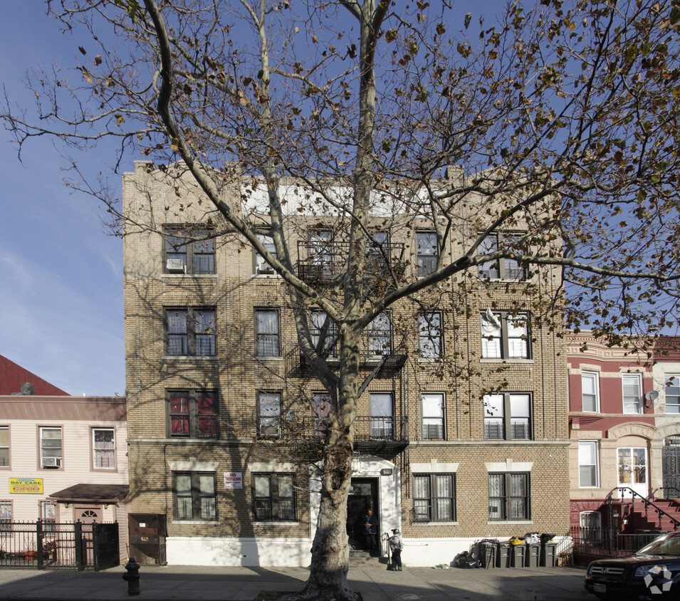

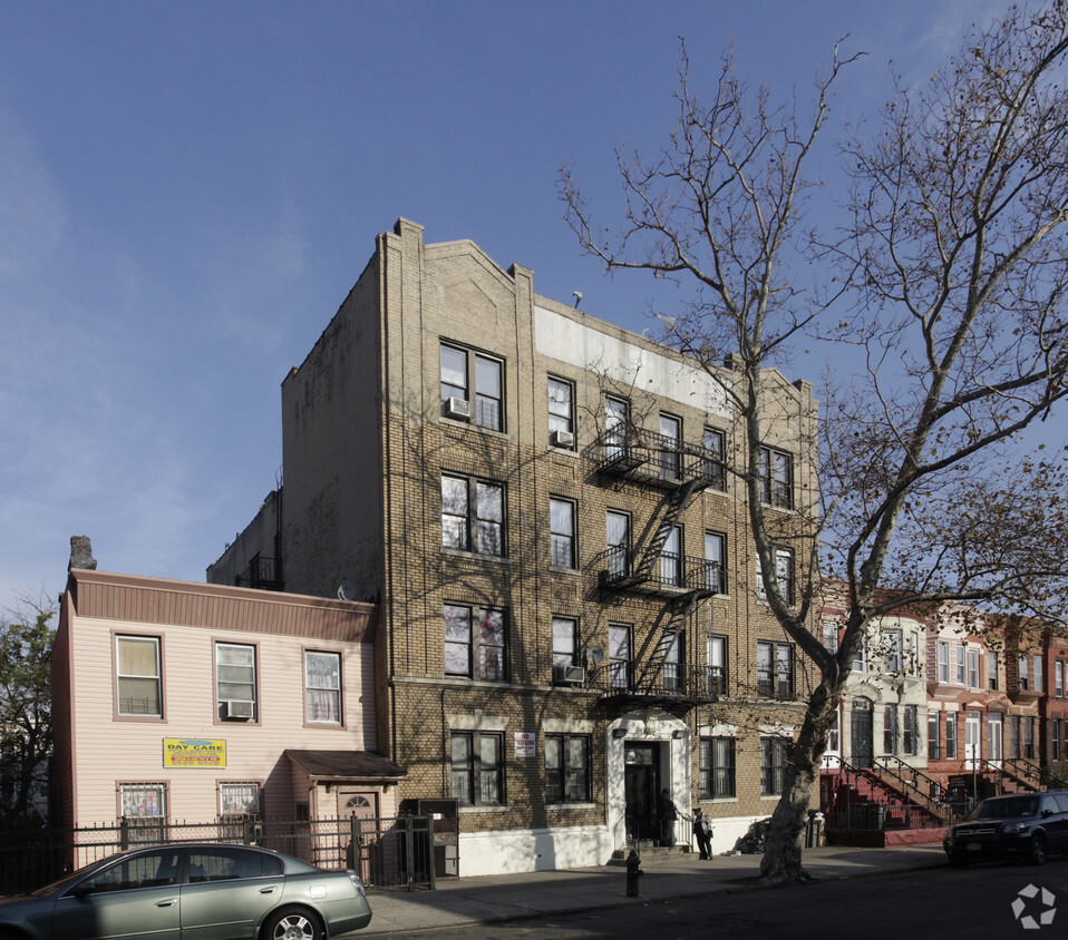
663 hancock offers a mixture of livability, design and quality. Based in Brooklyn's 11233 area, moving here offers a variety of nearby highlights. Be sure to check out the current floorplan options. The leasing team is waiting to show you all that this community has in store. Get moving on finding your next place. Contact or stop by 663 hancock to talk about leasing your next apartment!
663 hancock is an apartment community located in Kings County and the 11233 ZIP Code. This area is served by the New York City Geographic District #16 attendance zone.
Unique Features
As one of Brooklyn’s most eclectic neighborhoods, Stuyvesant Heights is a quaint urban neighborhood that boasts diversity, an abundance of mass transit, and historic charm. Located in the heart of Brooklyn, New York, this neighborhood houses some of the borough’s most historic brownstones and grand apartment buildings.
Though historic and vintage in appearance, the neighborhood is always improving with the addition of new restaurants, shops, and apartments around town. If you’re interested in bustling residential streets in a central urban location, you’ve found it. A plethora of apartment rentals reside along the historic streets of Stuyvesant Heights.
This neighborhood is the perfect blend of the old and the new. Explore tasty restaurants such as Peaches, a well-known place for modern, Southern cuisine in a historic brownstone. Enjoy numerous playgrounds, sports fields, and athletic courts within small green spaces around the neighborhood.
Learn more about living in Stuyvesant HeightsCompare neighborhood and city base rent averages by bedroom.
| Stuyvesant Heights | Brooklyn, NY | |
|---|---|---|
| Studio | $2,741 | $2,674 |
| 1 Bedroom | $2,939 | $2,996 |
| 2 Bedrooms | $2,907 | $3,925 |
| 3 Bedrooms | $3,412 | $4,864 |
| Colleges & Universities | Distance | ||
|---|---|---|---|
| Colleges & Universities | Distance | ||
| Drive: | 8 min | 2.6 mi | |
| Drive: | 8 min | 2.6 mi | |
| Drive: | 7 min | 2.8 mi | |
| Drive: | 9 min | 3.3 mi |


Transportation options available in Brooklyn include Utica Avenue, located 0.5 mile from 663 hancock. 663 hancock is near LaGuardia, located 9.1 miles or 20 minutes away, and John F Kennedy International, located 10.5 miles or 20 minutes away.
| Transit / Subway | Distance | ||
|---|---|---|---|
| Transit / Subway | Distance | ||
|
|
Walk: | 10 min | 0.5 mi |
|
|
Walk: | 12 min | 0.6 mi |
|
|
Walk: | 12 min | 0.6 mi |
|
|
Walk: | 13 min | 0.7 mi |
|
|
Walk: | 13 min | 0.7 mi |
| Commuter Rail | Distance | ||
|---|---|---|---|
| Commuter Rail | Distance | ||
|
|
Drive: | 4 min | 1.5 mi |
|
|
Drive: | 5 min | 2.1 mi |
|
|
Drive: | 8 min | 2.9 mi |
|
|
Drive: | 14 min | 4.8 mi |
|
|
Drive: | 15 min | 5.1 mi |
| Airports | Distance | ||
|---|---|---|---|
| Airports | Distance | ||
|
LaGuardia
|
Drive: | 20 min | 9.1 mi |
|
John F Kennedy International
|
Drive: | 20 min | 10.5 mi |
Scores provided by
Traffic
-Airport
-Businesses
-Scores provided by
HowLoud What is a Sound Score Rating? A Sound Score Rating aggregates noise caused by vehicle traffic, airplane traffic and local sources. How It WorksTime and distance from 663 hancock.
| Shopping Centers | Distance | ||
|---|---|---|---|
| Shopping Centers | Distance | ||
| Drive: | 5 min | 1.7 mi | |
| Drive: | 6 min | 2.0 mi |
| Parks and Recreation | Distance | ||
|---|---|---|---|
| Parks and Recreation | Distance | ||
|
St. John's Park
|
Walk: | 20 min | 1.0 mi |
|
Brooklyn Children's Museum
|
Drive: | 5 min | 1.4 mi |
|
Maria Hernandez Park
|
Drive: | 6 min | 1.7 mi |
|
Crispus Attucks Playground
|
Drive: | 5 min | 1.8 mi |
|
Hattie Carthan Garden
|
Drive: | 7 min | 2.0 mi |
| Hospitals | Distance | ||
|---|---|---|---|
| Hospitals | Distance | ||
| Walk: | 17 min | 0.9 mi | |
| Drive: | 4 min | 1.4 mi | |
| Drive: | 6 min | 1.7 mi |
| Military Bases | Distance | ||
|---|---|---|---|
| Military Bases | Distance | ||
| Drive: | 20 min | 8.0 mi | |
| Drive: | 26 min | 9.7 mi |
What Are Walk Score®, Transit Score®, and Bike Score® Ratings?
Walk Score® measures the walkability of any address. Transit Score® measures access to public transit. Bike Score® measures the bikeability of any address.
What is a Sound Score Rating?
A Sound Score Rating aggregates noise caused by vehicle traffic, airplane traffic and local sources.
663 Hancock St
Brooklyn, NY 11233


