
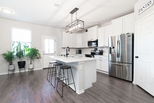


$2,000
/ Month
6603 Freedom Rnch
San Antonio, TX 78242
2 Weeks Ago
|
Edit
Favorites
-
Bedrooms
3
-
Bathrooms
2.5
-
Square Feet
2,076 sq ft
6603 Freedom Rnch

Favorites
Contact
- Listed by GSG Property Management | GSG Property Management
Location
Get Directions
Framed by the Cleto Rodriguez Freeway and the PanAm Expressway, South San Antonio includes Palo Alto College on its southeast side and Lackland Air Force Base on its northwest side. With less than 15 minutes to downtown and easy access to major roadways, South San Antonio is a great option for students, military personnel, and commuters. In addition to Palo Alto College, students have access to Texas A&M University San Antonio and Baptist University of the Americas.
Those who enjoy thrifting will appreciate Traders Village San Antonio, situated on the southeast side of the neighborhood. South San Antonio is home to Pearsall Park, a 505-acre park with hiking trails, a playground, the Pearsall Water-Skate Park, and Pearsall Dog Park. Shops and restaurants are scattered throughout the neighborhood with a heavy concentration along Military Drive.
Learn more about living in South San Antonio
Education
| Colleges & Universities | Distance | ||
|---|---|---|---|
| Colleges & Universities | Distance | ||
| Drive: | 13 min | 6.4 mi | |
| Drive: | 11 min | 8.3 mi | |
| Drive: | 15 min | 10.5 mi | |
| Drive: | 17 min | 10.6 mi |
6603 Freedom Rnch is within 13 minutes or 6.4 miles from St. Philip's College, SWC. It is also near Palo Alto College and Our Lady of the Lake Univ..
Schools


Public Elementary School
Grades PK-5
510 Students
Attendance Zone
Public Elementary School
Grades PK-5
298 Students
Attendance Zone
Public Middle & High School
Grades 6-12
379 Students
Nearby
Public Middle School
Grades 6-8
432 Students
Attendance Zone
Private Elementary, Middle & High School
Grades PK-12
64 Students
Nearby
Private Elementary School
Grades PK-5
44 Students
Nearby
School data provided by
 The GreatSchools Rating helps parents compare schools within a state based on a variety of school quality indicators and provides a helpful picture of how effectively each school serves all of its students. Ratings are on a scale of 1 (below average) to 10 (above average) and can include test scores, college readiness, academic progress, advanced courses, equity, discipline and attendance data. We also advise parents to visit schools, consider other information on school performance and programs, and consider family needs as part of the school selection process.
View GreatSchools Rating Methodology
Data provided by GreatSchools.org © 2026. All rights reserved.
View GreatSchools Rating Methodology
Data provided by GreatSchools.org © 2026. All rights reserved.
Getting Around
 What do Walkability, Transit, Drivability, and Bikeability mean?
Walkability measures the walking distance to day-to-day needs.
Transit measures access to public transportation.
Drivability measures congestion, parking availability, and access to major roads.
Bikeability measures the suitability for cycling.
How It Works
What do Walkability, Transit, Drivability, and Bikeability mean?
Walkability measures the walking distance to day-to-day needs.
Transit measures access to public transportation.
Drivability measures congestion, parking availability, and access to major roads.
Bikeability measures the suitability for cycling.
How It Works
Fairly Walkable
Walkability
40
/ 100
Limited Public Transit
Transit
30
/ 100
Exceptionally Drivable
Drivability
100
/ 100
Fairly Bikeable
Bikeability
40
/ 100
Scores provided by
-
Soundscore™
-
/ 100
Traffic
-Airport
-Businesses
-Scores provided by
HowLoud What is a Sound Score Rating? A Sound Score Rating aggregates noise caused by vehicle traffic, airplane traffic and local sources. How It WorksYou May Also Like
Similar Rentals Nearby
-
-
-
-
-
-
-
-
-
3 Beds$2,035+4 Beds$2,335+Total Monthly Price12 Month LeaseTotal Monthly Price NewPrices include required monthly fees of $140.Base Rent:3 Beds$1,895+4 Beds$2,195+Discounts
-
3 Beds$2,294+4 Beds$2,872Total Monthly PriceTotal Monthly Price NewPrices include base rent and required monthly fees of $119. Variable costs based on usage may apply.Base Rent:3 Beds$2,175+4 Beds$2,753Specials


What Are Walk Score®, Transit Score®, and Bike Score® Ratings?
Walk Score® measures the walkability of any address. Transit Score® measures access to public transit. Bike Score® measures the bikeability of any address.
What is a Sound Score Rating?
A Sound Score Rating aggregates noise caused by vehicle traffic, airplane traffic and local sources.
6603 Freedom Rnch
San Antonio, TX 78242