

$2,850
/ Month
634 W Jefferson St
Philadelphia, PA 19122
2 Weeks Ago
Favorites
634 W Jefferson St

Favorites
Check Back Soon for Upcoming Availability
| Beds | Baths | Average SF |
|---|---|---|
| 4 Bedrooms 4 Bedrooms 4 Br | 3 Baths 3 Baths 3 Ba | — |
Fees and Policies
The fees below are based on community-supplied data and may exclude additional fees and utilities.
- Dogs Allowed
-
Fees not specified
- Cats Allowed
-
Fees not specified
About This Property
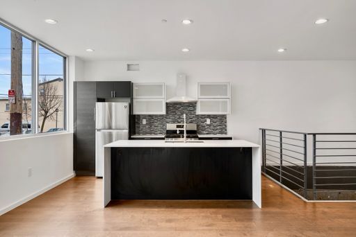
634-636 Jefferson St, Philadelphia, PA 19122 FIRST MONTH FREE ON A 13 MONTHS LEASE. These new apartments got it all: -Secured entry -Natural light -Washer/Dryer in unit -Everything is new from head to toe -Large walk-in closets -Shared backyard -Shared rooftop -Balconies ( select units ) -Convenient location -On-site management -Pet friendly ( $350 per pet, one time fee ) Pet Policy: Cats allowed, Dogs allowed Call NOW to schedule a tour!
634 W Jefferson St is a house located in Philadelphia County and the 19122 ZIP Code. This area is served by the Walter D Palmer Leadership Learning Partners Cs attendance zone.
House Features
- Washer/Dryer
- Washer/Dryer Hookup
- Dishwasher
Location
Get Directions
Not to be confused with Northeast Philadelphia, North Philadelphia East encompasses the smaller subsets of Ludlow, Yorktown, West Kensington, Poplar, and Callowhill. This composite area runs from the Vine Street Expressway, stretching north to Erie Avenue. Broad Street acts as its eastern border, and the western edge runs a jagged line separating North Philadelphia East from the nearby Kensington, Port Richmond, and Fishtown neighborhoods. With such a long stretch of city, the neighborhood offers a diverse blend of important city landmarks, such as renowned musical venues the Electric Factory and Union Transfer, and Temple University, North Philadelphia's premiere site of higher learning.
Learn more about living in North Philadelphia EastBelow are rent ranges for similar nearby apartments
| Beds | Average Size | Lowest | Typical | Premium |
|---|---|---|---|---|
| Studio Studio Studio | 477-483 Sq Ft | $695 | $1,517 | $5,300 |
| 1 Bed 1 Bed 1 Bed | 718-721 Sq Ft | $250 | $1,900 | $6,963 |
| 2 Beds 2 Beds 2 Beds | 997-999 Sq Ft | $499 | $2,044 | $9,995 |
| 3 Beds 3 Beds 3 Beds | 1417 Sq Ft | $599 | $2,084 | $6,732 |
| 4 Beds 4 Beds 4 Beds | 1709-1712 Sq Ft | $500 | $2,337 | $4,990 |
Amenities
- Washer/Dryer
- Washer/Dryer Hookup
- Dishwasher
Education
| Colleges & Universities | Distance | ||
|---|---|---|---|
| Colleges & Universities | Distance | ||
| Walk: | 17 min | 0.9 mi | |
| Drive: | 4 min | 2.1 mi | |
| Drive: | 6 min | 2.1 mi | |
| Drive: | 6 min | 2.8 mi |
634 W Jefferson St is within 17 minutes or 0.9 mile from Temple University, Main Campus. It is also near C.C. of Philadelphia and Drexel Univ., Hahnemann.
Schools

Charter Elementary, Middle & High School
Grades PK-12
1,144 Students
Nearby
Public Elementary & Middle School
Grades PK-8
202 Students
Attendance Zone
Private Elementary, Middle & High School
Grades PK-12
272 Students
Nearby
Private Elementary School
Grades PK-6
Nearby
School data provided by
 The GreatSchools Rating helps parents compare schools within a state based on a variety of school quality indicators and provides a helpful picture of how effectively each school serves all of its students. Ratings are on a scale of 1 (below average) to 10 (above average) and can include test scores, college readiness, academic progress, advanced courses, equity, discipline and attendance data. We also advise parents to visit schools, consider other information on school performance and programs, and consider family needs as part of the school selection process.
View GreatSchools Rating Methodology
Data provided by GreatSchools.org © 2025. All rights reserved.
View GreatSchools Rating Methodology
Data provided by GreatSchools.org © 2025. All rights reserved.
Transportation options available in Philadelphia include Girard Av & 7Th St, located 0.3 mile from 634 W Jefferson St. 634 W Jefferson St is near Philadelphia International, located 13.6 miles or 24 minutes away, and Trenton Mercer, located 32.5 miles or 49 minutes away.
| Transit / Subway | Distance | ||
|---|---|---|---|
| Transit / Subway | Distance | ||
| Walk: | 5 min | 0.3 mi | |
| Walk: | 7 min | 0.4 mi | |
| Walk: | 7 min | 0.4 mi | |
| Walk: | 9 min | 0.5 mi | |
| Walk: | 10 min | 0.6 mi |
| Commuter Rail | Distance | ||
|---|---|---|---|
| Commuter Rail | Distance | ||
|
|
Walk: | 13 min | 0.7 mi |
|
|
Drive: | 5 min | 1.8 mi |
|
|
Drive: | 5 min | 2.0 mi |
|
|
Drive: | 5 min | 2.0 mi |
|
|
Drive: | 7 min | 2.4 mi |
| Airports | Distance | ||
|---|---|---|---|
| Airports | Distance | ||
|
Philadelphia International
|
Drive: | 24 min | 13.6 mi |
|
Trenton Mercer
|
Drive: | 49 min | 32.5 mi |
Time and distance from 634 W Jefferson St.
| Shopping Centers | Distance | ||
|---|---|---|---|
| Shopping Centers | Distance | ||
| Walk: | 8 min | 0.4 mi | |
| Walk: | 11 min | 0.6 mi | |
| Walk: | 15 min | 0.8 mi |
634 W Jefferson St has 3 shopping centers within 0.8 mile, which is about a 15-minute walk. The miles and minutes will be for the farthest away property.
| Parks and Recreation | Distance | ||
|---|---|---|---|
| Parks and Recreation | Distance | ||
|
Edgar Allan Poe Nat'l Historic Site
|
Drive: | 3 min | 1.2 mi |
|
Wagner Free Institute of Science
|
Drive: | 4 min | 1.3 mi |
|
Independence National Historical Park
|
Drive: | 4 min | 1.7 mi |
|
The Academy of Natural Sciences
|
Drive: | 5 min | 2.6 mi |
|
Fels Planetarium
|
Drive: | 6 min | 3.0 mi |
634 W Jefferson St has 5 parks within 3.0 miles, including Edgar Allan Poe Nat'l Historic Site, Wagner Free Institute of Science, and Independence National Historical Park.
| Hospitals | Distance | ||
|---|---|---|---|
| Hospitals | Distance | ||
| Drive: | 4 min | 2.0 mi | |
| Drive: | 5 min | 2.2 mi | |
| Drive: | 6 min | 2.3 mi |
634 W Jefferson St has 3 hospitals within 2.3 miles, the nearest is Hahnemann University Hospital which is 2.0 miles away and a 4 minute drive.
| Military Bases | Distance | ||
|---|---|---|---|
| Military Bases | Distance | ||
| Drive: | 14 min | 8.0 mi |
634 W Jefferson St is 8.0 miles and a 14 minute drive from Philadelphia Naval Busi Center.
You May Also Like
Similar Rentals Nearby


What Are Walk Score®, Transit Score®, and Bike Score® Ratings?
Walk Score® measures the walkability of any address. Transit Score® measures access to public transit. Bike Score® measures the bikeability of any address.
What is a Sound Score Rating?
A Sound Score Rating aggregates noise caused by vehicle traffic, airplane traffic and local sources
634 W Jefferson St
Philadelphia, PA 19122